METAR & TAF F05
Current METAR
Observed 13:15Z
KF05 271315Z AUTO 20007KT 10SM CLR 28/17 A2994 RMK AO2 T02810172
- Wind
- 200° @ 7 kt
- Visibility
- 10 SM
- Temp / Dew
- 28°C / 17°C
- Altimeter
- 29.94 inHg
- Clouds
- CLR
- Density alt
- 3,103 ft
- Ceiling
- Unlimited
- Rules
- VFR
Airport info & contacts
Manager on record, flight service, ARTCC, attendance schedule and pattern altitude — published by the FAA and refreshed every 28 days.
Location
- From city
- 4 NM N
- VFR sectional
- DALLAS-FT WORTH
- ARTCC
- ZFW · FORT WORTH
- NOTAM facility
- F05 (NOTAM-D)
Airport manager
- Name
- KYLE MILLER
- Phone
- 940-552-2182
- Address
- 12557 HAMP NAYLOR DRIVE, VERNON TX 76384
Flight service · Hours
- FSS FTW
- FORT WORTH1-800-WX-BRIEF
- Attendance
- MON-SAT · 0800-1700
Frequencies
Tap any row to copy the frequency to your clipboard.
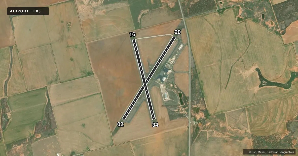
Runways & pattern
Full pagePattern entry · RWY 20
LEFT TRAFFIC| Runway | Heading (°M) | Length | Surface | Traffic |
|---|---|---|---|---|
| 02/20Favored | 24° / 204° | 5,099 ft | ASPH | Standard L |
| 16/34 | 158° / 338° | 4,304 ft | ASPH | Standard L |
Runway end performance
| End | TORA | TODA | ASDA | LDA | VGSI | Approach lights | Obstruction |
|---|---|---|---|---|---|---|---|
| 02 | — | — | — | — | — | — | 15', road, 710' from thr, 295' R of cntrln, slope 34 |
| 20 | — | — | — | — | VASI 4-box left(3°) | — | 10', road, 617' from thr, 317' R of cntrln, slope 41 |
| 16 | — | — | — | — | — | — | 12', road, 432' from thr, 0' R of cntrln, slope 19 |
Declared distances in feet. TORA = takeoff run available, TODA = takeoff distance, ASDA = accelerate-stop, LDA = landing distance.
Airport sketch
Runways drawn to scale from FAA survey coordinates, rendered over satellite imagery. Not for navigation.
Approaches & charts
Services on the field
Fuel grades, oxygen, maintenance, ramp storage and lighting — as declared to the FAA by the airport operator.
Fuel & services
- Fuel
- 100LLA+
- Oxygen (bottled)
- Not available
- Oxygen (bulk)
- Not available
- Other services
- AGRI,INSTR
Ramp & ground
- Transient storage
- Tie-down
- Hangar
- Landing fee
- No fee published
- Customs
- Not available
- Lighting schedule
- SEE RMK
- Beacon schedule
- SS-SR
- Beacon
- White / Green (civil land)(WG)
- Wind indicator
- Lighted
- Segmented circle
- Yes
Fuel & FBOs
Cheapest 100LL and Jet A on the field and nearby. Always confirm with the FBO before taxi.
Airport notes
Surface conditions, obstructions, local procedures, lighting outages and other notes published with each FAA cycle.
General notes
- SEASONAL EXTSV AERIAL AG OPS.
- FOR CD CTC FORT WORTH ARTCC AT 817-858-7584.
- RWY 2/20 GRASS ENCROACHING 13 FT EACH SIDE
Lighting notes
- MIRLS DUSK-DAWN.
Fuel notes
- 100LL100 LL SELF-SERVE. 100LL, JET A+ FULL SERVE; AFT HRS SVC CALL 940-839-6365.
Other notes
- THIS AIRPORT HAS BEEN SURVEYED BY THE NATIONAL GEODETIC SURVEY.
- PRE-DATES ACT.
VFR map & nearby airports
VFR sectional. Tap any ICAO chip to open that airport.
Key facts · F05
Answer card- ICAO
- F05
- Name
- WILBARGER COUNTY
- Location
- VERNON, TEXAS
- Elevation
- 1,264.7 ft MSL
- Traffic pattern altitude
- 2,264.7 ft MSL (1,000 AGL)
- Control tower
- Non-towered (use CTAF)
- Total runways
- 2
- Longest runway
- 02/20 · 5,099 ft
- Published ILS approaches
- 0
- Published frequencies
- 5
- Magnetic variation
- 8°
- Current flight rules
- VFR
- Current wind
- 200° at 7 kt
- Favored runway now
- RWY 20
Wilbarger County Airport sits in Vernon, Texas. The field elevation is 1,264.7 ft MSL. It has two asphalt runways. The longest is Runway 02/20 at 5,099 ft. There is no control tower. No ILS approaches are published. The pattern altitude is not published, so use the standard 1,000 ft AGL unless the current Chart Supplement says otherwise.
The on-field FBO is Wilbarger County Airport. It carries 100LL and Jet A. Published remarks say 100LL self-serve is available. Full service is also available. After-hours service is listed by phone. Runway 02/20 has grass encroaching 13 ft on each side. Medium intensity runway lights operate from dusk to dawn.
This is a non-towered field with seasonal aerial agricultural work. Expect traffic to be busy when ag ops are active. For clearance delivery, Fort Worth ARTCC is listed in the remarks. If you need current noise, lighting, or fuel service details before you go, call the airport operator or the FBO directly. The field sits in open country, so wind and dust can matter on the ground. Check the current Chart Supplement for any published local procedures before departure.