METAR & TAF 92F
92F does not publish a METAR.
Showing the nearest reporting station: KFDR (FREDERICK RGNL) · 15.0 NM away. Conditions at 92F may differ.
METAR · KFDR
Observed 09:53Z
KFDR 270953Z AUTO 17006KT 10SM CLR 26/18 A2988 RMK AO2 SLP096 T02560178
- Wind
- 170° @ 6 kt
- Visibility
- 10 SM
- Temp / Dew
- 26°C / 18°C
- Altimeter
- 29.88 inHg
- Clouds
- CLR
- Density alt
- 2,777 ft
- Ceiling
- Unlimited
- Rules
- VFR
Airport info & contacts
Manager on record, flight service, ARTCC, attendance schedule and pattern altitude — published by the FAA and refreshed every 28 days.
Location
- From city
- 3 NM SW
- VFR sectional
- DALLAS-FT WORTH
- ARTCC
- ZFW · FORT WORTH
- NOTAM facility
- MLC (NOTAM-D)
Airport manager
- Name
- JEFF BURK
- Phone
- 580-597-3390
- Address
- 302 3RD ST, 302 3RD ST, CHATTANOOGA OK 73528
Flight service · Hours
- FSS MLC
- MC ALESTER1-800-WX-BRIEF
- Attendance
- IREG
Frequencies
Tap any row to copy the frequency to your clipboard.
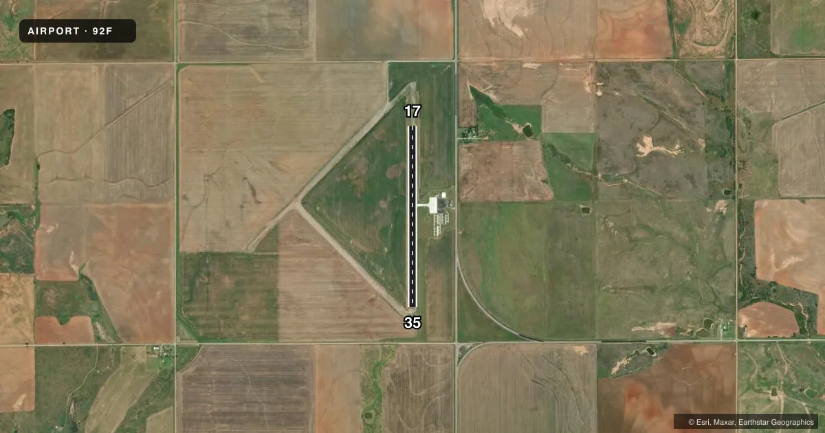
Runways & pattern
Full pagePattern entry · RWY 17
LEFT TRAFFICAirport sketch
Runways drawn to scale from FAA survey coordinates, rendered over satellite imagery. Not for navigation.
Approaches & charts
Services on the field
Fuel grades, oxygen, maintenance, ramp storage and lighting — as declared to the FAA by the airport operator.
Fuel & services
- Fuel
- Not available
- Oxygen (bottled)
- Not available
- Oxygen (bulk)
- Not available
- Airframe repair
- Not available
- Power plant repair
- Not available
- Other services
- AGRI,INSTR,RNTL
Ramp & ground
- Transient storage
- Tie-down
- Landing fee
- No fee published
- Customs
- Not available
- Lighting schedule
- SS-SR
- Beacon schedule
- SS-SR
- Beacon
- White / Green (civil land)(WG)
- Wind indicator
- Lighted
- Segmented circle
- Yes
Fuel & FBOs
Cheapest 100LL and Jet A on the field and nearby. Always confirm with the FBO before taxi.
Airport notes
Surface conditions, obstructions, local procedures, lighting outages and other notes published with each FAA cycle.
General notes
- ULTRALIGHTS ON AND IN VICINITY OF AIRPORT.
- FOR CD CTC FORT WORTH ARTCC AT 817-858-7584.
Other notes
- EXISTED PRIOR TO 1959.
VFR map & nearby airports
VFR sectional. Tap any ICAO chip to open that airport.
Key facts · 92F
Answer card- ICAO
- 92F
- Name
- CHATTANOOGA SKY HARBOR
- Location
- CHATTANOOGA, OKLAHOMA
- Elevation
- 1,135 ft MSL
- Traffic pattern altitude
- 2,135 ft MSL (1,000 AGL)
- Control tower
- Non-towered (use CTAF)
- Total runways
- 1
- Longest runway
- 17/35 · 3,400 ft
- Published ILS approaches
- 0
- Published frequencies
- 1
- Magnetic variation
- 7°
- Current flight rules
- VFR
- Current wind
- 170° at 6 kt
- Favored runway now
- RWY 17
Chattanooga Sky Harbor is in Chattanooga, Oklahoma. Field elevation is 1,135 ft MSL. The airport has one runway. Runway 17/35 is 3,400 ft long with an asphalt surface. There is no control tower, so expect self-announce traffic on CTAF 122.9. No ILS approaches are published here.
Pattern altitude is not published. Use the standard 1,000 ft AGL pattern unless local guidance says otherwise. At this field that works out to about 2,135 ft MSL. The published remarks also note that ultralights operate on and near the airport. Give them a wide berth and keep your scan active in the pattern.
For clearance delivery, contact Fort Worth ARTCC at 817-858-7584. There are no on-field FBOs listed in the facts, so verify fuel and services with the airport operator or by phone before you go. This is a small, non-towered field with a single short runway. Plan your arrival with the elevation and runway length in mind. Check density altitude before departure, especially on warm days.