METAR & TAF KHBR
Current METAR
Observed 12:53Z
KHBR 271253Z AUTO 20012KT 10SM CLR 26/18 A2993 RMK AO2 SLP111 T02610183
- Wind
- 200° @ 12 kt
- Visibility
- 10 SM
- Temp / Dew
- 26°C / 18°C
- Altimeter
- 29.93 inHg
- Clouds
- CLR
- Density alt
- 3,246 ft
- Ceiling
- Unlimited
- Rules
- VFR
Airport info & contacts
Manager on record, flight service, ARTCC, attendance schedule and pattern altitude — published by the FAA and refreshed every 28 days.
Location
- From city
- 3 NM SE
- VFR sectional
- DALLAS-FT WORTH
- ARTCC
- ZFW · FORT WORTH
- NOTAM facility
- HBR (NOTAM-D)
Airport manager
- Name
- KEVIN MAGRADY
- Phone
- 580-726-2719
- Address
- 22019 E 1396 RD, HOBART OK 73651
Flight service · Hours
- FSS MLC
- MC ALESTER1-800-WX-BRIEF
- Attendance
- MON-FRI · 0800-1600
Frequencies
Tap any row to copy the frequency to your clipboard.
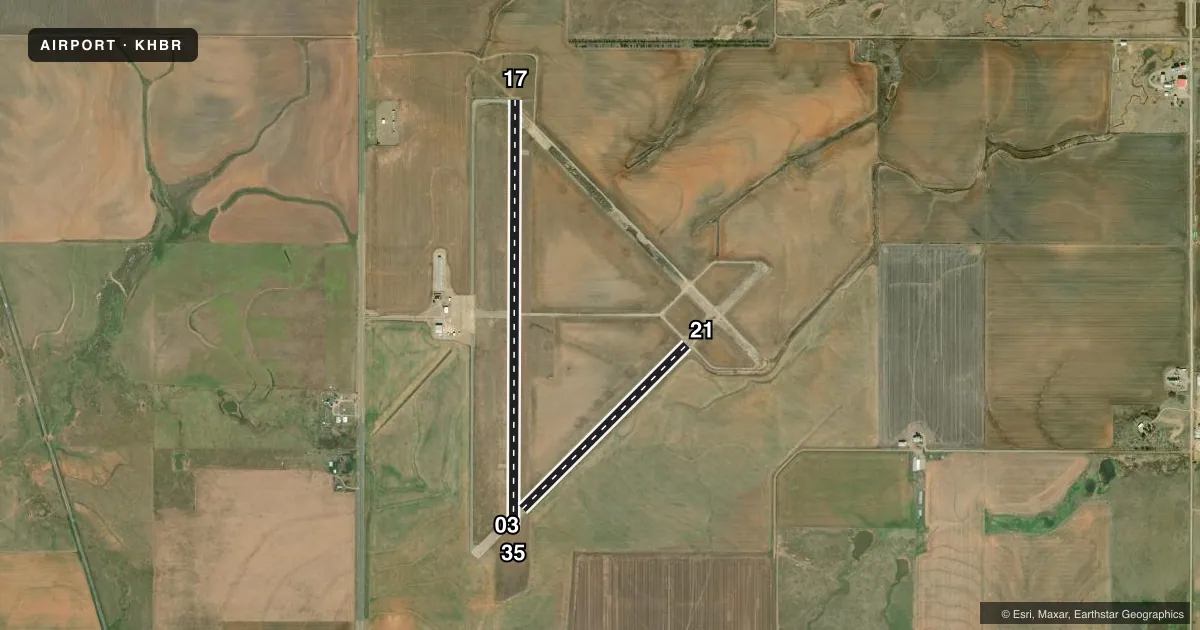
Runways & pattern
Full pagePattern entry · RWY 17
LEFT TRAFFIC| Runway | Heading (°M) | Length | Surface | Traffic |
|---|---|---|---|---|
| 17/35Favored | 173° / 353° | 5,507 ft | ASPH | Standard L |
| 03/21 | 38° / 218° | 2,975 ft | ASPH | Standard L |
Runway end performance
| End | TORA | TODA | ASDA | LDA | VGSI | Approach lights | Obstruction |
|---|---|---|---|---|---|---|---|
| 17 | — | — | — | — | PAPI 4-box left(3°) | — | — |
| 35 | — | — | — | — | PAPI 4-box left(3°) | — | — |
Declared distances in feet. TORA = takeoff run available, TODA = takeoff distance, ASDA = accelerate-stop, LDA = landing distance.
Airport sketch
Runways drawn to scale from FAA survey coordinates, rendered over satellite imagery. Not for navigation.
Approaches & charts
Services on the field
Fuel grades, oxygen, maintenance, ramp storage and lighting — as declared to the FAA by the airport operator.
Fuel & services
- Fuel
- 100LLA+
- Oxygen (bottled)
- Not available
- Oxygen (bulk)
- Not available
- Airframe repair
- Not available
- Power plant repair
- Not available
- Other services
- AGRI
Ramp & ground
- Transient storage
- Tie-down
- Landing fee
- No fee published
- Customs
- Not available
- Lighting schedule
- SS-SR
- Beacon schedule
- SS-SR
- Beacon
- White / Green (civil land)(WG)
- Wind indicator
- Lighted
- Segmented circle
- Yes
Fuel & FBOs
Cheapest 100LL and Jet A on the field and nearby. Always confirm with the FBO before taxi.
Airport notes
Surface conditions, obstructions, local procedures, lighting outages and other notes published with each FAA cycle.
General notes
- FOR CD IF UNA TO CTC ON FSS FREQ, CTC FORT WORTH ARTCC AT 817-858-7584.
Fuel notes
- 100LLFUEL AVBL 24 HR SELF SERVICE WITH MAJOR CREDIT CARD.
Approach & departure obstructions
- 03RWY 03 MARKINGS SVRLY FADED.
- 21RWY 21 MARKINGS SVRLY FADED.
Other notes
- PREDATES ACT.
VFR map & nearby airports
VFR sectional. Tap any ICAO chip to open that airport.
Key facts · KHBR
Answer card- ICAO
- KHBR
- Name
- HOBART RGNL
- Location
- HOBART, OKLAHOMA
- Elevation
- 1,563.2 ft MSL
- Traffic pattern altitude
- 2,563.2 ft MSL (1,000 AGL)
- Control tower
- Non-towered (use CTAF)
- Total runways
- 2
- Longest runway
- 17/35 · 5,507 ft
- Published ILS approaches
- 0
- Published frequencies
- 5
- Magnetic variation
- 7°
- Current flight rules
- VFR
- Current wind
- 200° at 12 kt
- Favored runway now
- RWY 17
Hobart RGNL sits in Hobart, Oklahoma. The field elevation is 1,563.2 ft MSL. It has two asphalt runways. The longest is 17/35 at 5,507 ft. The other runway is 03/21 at 2,975 ft. There is no control tower, so expect non-towered operations on CTAF 122.8.
No ILS approaches are published here. The published pattern altitude is not listed, so use the standard 1,000 ft AGL for light piston traffic unless the current FAA Chart Supplement says otherwise. That puts the pattern at about 2,563 ft MSL based on the field elevation. Check the current Chart Supplement before you go if you need anything nonstandard.
Hobart Regional Airport is on the field and carries 100LL and Jet A. Fuel is available 24 hours self service with a major credit card. Runway 03 and runway 21 markings are reported as severely faded, so plan a careful visual scan on arrival and departure. If you need clearance delivery and cannot reach Flight Service on the published frequency, the remarks say to contact Fort Worth ARTCC. This is a good airport to brief ahead of time because the field sits at higher elevation and the markings on the 03/21 runway need extra attention.