METAR & TAF KOJA
Current METAR
Observed 13:10Z
KOJA 271310Z AUTO 20009KT 10SM CLR 27/18 A2993 RMK AO2 T02690176
- Wind
- 200° @ 9 kt
- Visibility
- 10 SM
- Temp / Dew
- 27°C / 18°C
- Altimeter
- 29.93 inHg
- Clouds
- CLR
- Density alt
- 3,418 ft
- Ceiling
- Unlimited
- Rules
- VFR
Airport info & contacts
Manager on record, flight service, ARTCC, attendance schedule and pattern altitude — published by the FAA and refreshed every 28 days.
Location
- From city
- 2 NM NE
- VFR sectional
- DALLAS-FT WORTH
- ARTCC
- ZFW · FORT WORTH
- NOTAM facility
- MLC (NOTAM-D)
Airport manager
- Name
- MARK SCHOONMAKER
- Phone
- 580-774-1971
- Address
- 3000 LOGAN ROAD, WEATHERFORD OK 73096
Flight service · Hours
- FSS MLC
- MC ALESTER1-800-WX-BRIEF
- Attendance
- MON-FRI · 0800-1730
- SAT · 0800-1700
- SUN · 1200-1700
Frequencies
Tap any row to copy the frequency to your clipboard.
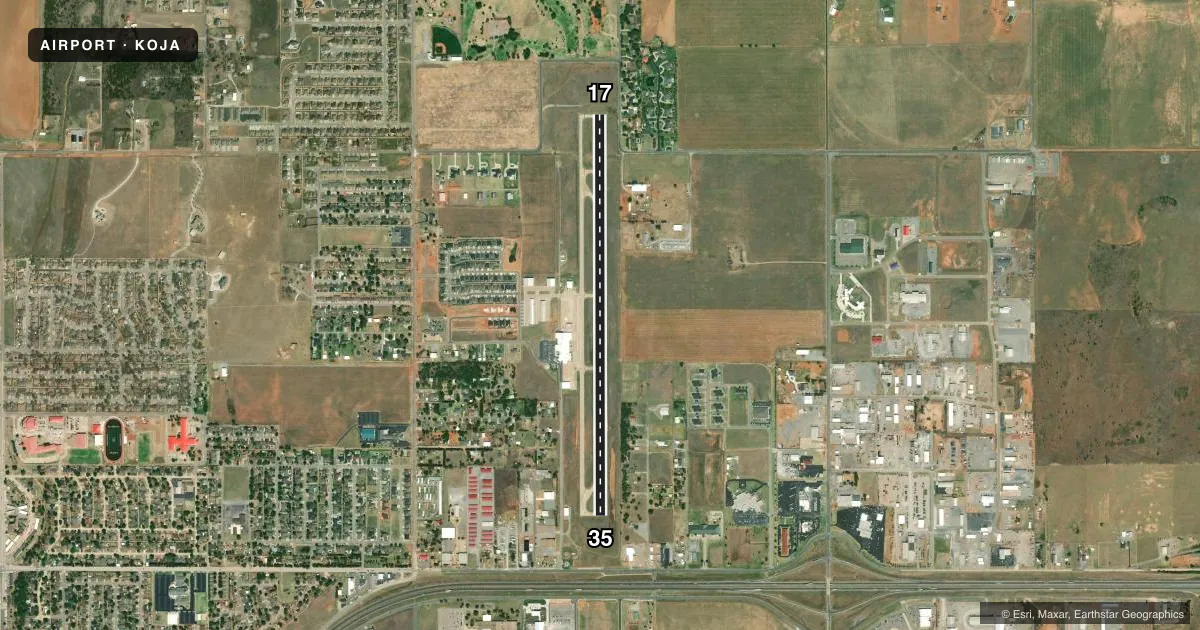
Runways & pattern
Full pagePattern entry · RWY 17
LEFT TRAFFICRunway end performance
| End | TORA | TODA | ASDA | LDA | VGSI | Approach lights | Obstruction |
|---|---|---|---|---|---|---|---|
| 17 | — | — | — | — | PAPI 2-box left(3.34°) | — | 42', trees, 851' from thr, 165' R of cntrln, slope 15 |
| 35 | — | — | — | — | PAPI 2-box left(2.92°) | — | 49', pline, 1090' from thr, 0' R of cntrln, slope 18 |
Declared distances in feet. TORA = takeoff run available, TODA = takeoff distance, ASDA = accelerate-stop, LDA = landing distance.
Airport sketch
Runways drawn to scale from FAA survey coordinates, rendered over satellite imagery. Not for navigation.
Approaches & charts
Services on the field
Fuel grades, oxygen, maintenance, ramp storage and lighting — as declared to the FAA by the airport operator.
Fuel & services
- Fuel
- 100LLA+
- Oxygen (bottled)
- HIGH/LOW
- Oxygen (bulk)
- Not available
- Airframe repair
- Major
- Power plant repair
- Major
- Other services
- AVNCS,INSTR,RNTL
Ramp & ground
- Transient storage
- Tie-down
- Hangar
- Landing fee
- No fee published
- Customs
- Not available
- Lighting schedule
- SEE RMK
- Beacon schedule
- SS-SR
- Beacon
- White / Green (civil land)(WG)
- Wind indicator
- Lighted
- Segmented circle
- No
Fuel & FBOs
Cheapest 100LL and Jet A on the field and nearby. Always confirm with the FBO before taxi.
Airport notes
Surface conditions, obstructions, local procedures, lighting outages and other notes published with each FAA cycle.
General notes
- FOR CD CTC FORT WORTH ARTCC AT 817-858-7584.
- FBO CLSD SOME HOLS.
Lighting notes
- REIL RWY 17 & 35; MIRL RWY 17/35 ON SS-SR; INCR INTST - CTAF. PAPI RWY 17 & 35 ON CONSLY.
Approach & departure obstructions
- 17INSTA HWY 844 FT FM RWY 35 END BOTH SIDES CREATES 21:1 OBS-CLNC SLP.
Other notes
- INSTRCOURTESY CAR AVBL.
VFR map & nearby airports
VFR sectional. Tap any ICAO chip to open that airport.
Key facts · KOJA
Answer card- ICAO
- KOJA
- Name
- WEATHERFORD STAFFORD
- Location
- WEATHERFORD, OKLAHOMA
- Elevation
- 1,605.3 ft MSL
- Traffic pattern altitude
- 2,605.3 ft MSL (1,000 AGL)
- Control tower
- Non-towered (use CTAF)
- Total runways
- 1
- Longest runway
- 17/35 · 5,100 ft
- Published ILS approaches
- 0
- Published frequencies
- 2
- Magnetic variation
- 6°
- Current flight rules
- VFR
- Current wind
- 200° at 9 kt
- Favored runway now
- RWY 17
Weatherford Stafford Airport (KOJA) sits in Weatherford, Oklahoma. Field elevation is 1,605.3 ft MSL. The airport has one runway, 17/35, at 5,100 ft of concrete. There is no control tower. CTAF and UNICOM are both 122.8. No ILS approaches are published here.
Pattern altitude is not published, so use the standard 1,000 ft AGL unless the current Chart Supplement says otherwise. That puts the light-piston pattern at about 2,605.3 ft MSL based on the listed field elevation. Runway 17 and 35 have end identifier lights. They also have medium intensity runway lights from sunset to sunrise. PAPI is installed on both ends. Light intensity is controlled on CTAF.
Thomas P. Stafford Airport is the on-field FBO. It carries 100LL and Jet A. The FBO is closed on some holidays, so call ahead if you need service on a holiday. A courtesy car is available. One operational item to keep in mind is the interstate highway near the runway 35 end. That makes the departure and arrival picture worth a close look, especially on short or high-workload legs. For clearance delivery, contact Fort Worth ARTCC at 817-858-7584.