METAR & TAF 1O4
1O4 does not publish a METAR.
Showing the nearest reporting station: KOJA (WEATHERFORD STAFFORD) · 11.7 NM away. Conditions at 1O4 may differ.
METAR · KOJA
Observed 01:10Z
KOJA 240110Z AUTO 10005KT 10SM CLR 24/21 A3007 RMK AO2 T02360205
- Wind
- 100° @ 5 kt
- Visibility
- 10 SM
- Temp / Dew
- 24°C / 21°C
- Altimeter
- 30.07 inHg
- Clouds
- CLR
- Density alt
- 3,042 ft
- Ceiling
- Unlimited
- Rules
- VFR
Airport info & contacts
Manager on record, flight service, ARTCC, attendance schedule and pattern altitude — published by the FAA and refreshed every 28 days.
Location
- From city
- 1 NM SE
- VFR sectional
- DALLAS-FT WORTH
- ARTCC
- ZFW · FORT WORTH
- NOTAM facility
- MLC (NOTAM-D)
Airport manager
- Name
- RODNEY WILSON
- Phone
- 580-603-2636
- Address
- P. O. BOX 250, P. O. BOX 641, THOMAS OK 73669
Flight service · Hours
- FSS MLC
- MC ALESTER1-800-WX-BRIEF
- Attendance
- MON-FRI · 0800-1700
Frequencies
Tap any row to copy the frequency to your clipboard.
Runways & pattern
Full pagePattern entry · RWY 17
LEFT TRAFFICRunway end performance
| End | TORA | TODA | ASDA | LDA | VGSI | Approach lights | Obstruction |
|---|---|---|---|---|---|---|---|
| 17 | — | — | — | — | PAPI 2-box left(3°) | — | 18', road, 338' from thr, 0' R of cntrln, slope 7 |
| 35 | — | — | — | — | PAPI 2-box left(3°) | — | — |
Declared distances in feet. TORA = takeoff run available, TODA = takeoff distance, ASDA = accelerate-stop, LDA = landing distance.
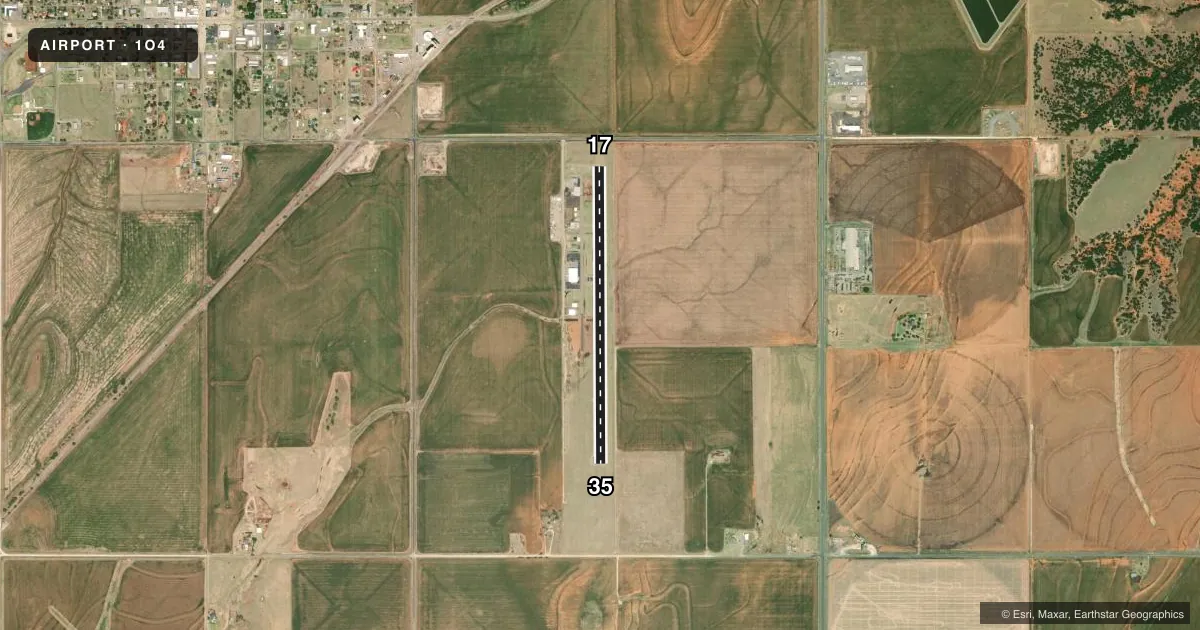
Airport sketch
Runways drawn to scale from FAA survey coordinates, rendered over satellite imagery. Not for navigation.
Approaches & charts
Services on the field
Fuel grades, oxygen, maintenance, ramp storage and lighting — as declared to the FAA by the airport operator.
Fuel & services
- Fuel
- 100LLA+
- Oxygen (bottled)
- Not available
- Oxygen (bulk)
- Not available
- Airframe repair
- Not available
- Power plant repair
- Not available
- Other services
- AGRI,INSTR,SALES
Ramp & ground
- Transient storage
- Tie-down
- Landing fee
- No fee published
- Customs
- Not available
- Lighting schedule
- SEE RMK
- Beacon schedule
- SS-SR
- Beacon
- White / Green (civil land)(WG)
- Wind indicator
- Lighted
- Segmented circle
- No
Fuel & FBOs
Cheapest 100LL and Jet A on the field and nearby. Always confirm with the FBO before taxi.
Airport notes
Surface conditions, obstructions, local procedures, lighting outages and other notes published with each FAA cycle.
General notes
- FOR CD CTC FORT WORTH ARTCC AT 817-858-7584.
- OVNGT HNGR SPACE, COURTESY CAR, OTR SVCS,CTC AMGR 580-603-2636.
Lighting notes
- MIRL RWY 17/35 ON SS-SR PRESET LOW INTST; INCR/DECR INTST - CTAF. PAPI RWY 17 & 35 ON CONSLY.
Fuel notes
- 100LLAVBL 24 HRS SELF SVC WITH CREDIT CARD.
- A+AVBL 24 HRS SELF SVC WITH CREDIT CARD.
Approach & departure obstructions
- 17PAPI UNUSBL BYD 8 DEGS RIGHT OF CNTRLN.
- 1730:1 OBS CLC SLOPE TO DTHR.
VFR map & nearby airports
VFR sectional. Tap any ICAO chip to open that airport.
Key facts · 1O4
Answer card- ICAO
- 1O4
- Name
- THOMAS MUNI
- Location
- THOMAS, OKLAHOMA
- Elevation
- 1,732.5 ft MSL
- Traffic pattern altitude
- 2,732.5 ft MSL (1,000 AGL)
- Control tower
- Non-towered (use CTAF)
- Total runways
- 1
- Longest runway
- 17/35 · 3,771 ft
- Published ILS approaches
- 0
- Published frequencies
- 1
- Magnetic variation
- 5°
- Current flight rules
- VFR
- Current wind
- 100° at 5 kt
- Favored runway now
- RWY 17
Thomas Muni is in Thomas, Oklahoma. The field elevation is 1,732.5 ft MSL. It has one runway. Runway 17/35 is 3,771 ft long and asphalt. There is no control tower. CTAF is 122.9. No ILS approaches are published here.
The published pattern altitude is not listed, so use the standard 1,000 ft AGL unless the current Chart Supplement says otherwise. That puts the light aircraft pattern at about 2,732.5 ft MSL. The airport sits in western Oklahoma, so expect open-country flying with little terrain relief. The runway lighting on 17/35 is preset to low intensity from sunset to sunrise. You can raise or lower it on CTAF. The PAPIs on 17 and 35 are on continuously.
There are no on-field FBOs listed. Published remarks say overnight hangar space, a courtesy car and other services are available. Contact the manager at 580-603-2636 before arrival. Self-serve A+ fuel and 100LL are available 24 hours with a credit card. For clearance delivery, contact Fort Worth ARTCC at 817-858-7584. On runway 17, note the PAPI is unusable beyond 8 degrees right of centerline. There is also a 30 to 1 obstacle clearance slope to the displaced threshold on runway 17. Check that on departure and arrival planning.