METAR & TAF O65
O65 does not publish a METAR.
Showing the nearest reporting station: KJWG (WATONGA RGNL) · 15.9 NM away. Conditions at O65 may differ.
METAR · KJWG
Observed 16:55Z
KJWG 271655Z AUTO 24011KT 10SM CLR 36/17 A2993 RMK AO2 T03590174
- Wind
- 240° @ 11 kt
- Visibility
- 10 SM
- Temp / Dew
- 36°C / 17°C
- Altimeter
- 29.93 inHg
- Clouds
- CLR
- Density alt
- 4,005 ft
- Ceiling
- Unlimited
- Rules
- VFR
Airport info & contacts
Manager on record, flight service, ARTCC, attendance schedule and pattern altitude — published by the FAA and refreshed every 28 days.
Location
- From city
- 1 NM SE
- VFR sectional
- WICHITA
- ARTCC
- ZKC · KANSAS CITY
- NOTAM facility
- MLC (NOTAM-D)
Airport manager
- Name
- RICHARD RAUPE
- Phone
- 580-822-3035
- Address
- PO BOX 800, OKEENE OK 73763
Flight service · Hours
- FSS MLC
- MC ALESTER1-800-WX-BRIEF
- Attendance
- Unattended
Frequencies
Tap any row to copy the frequency to your clipboard.
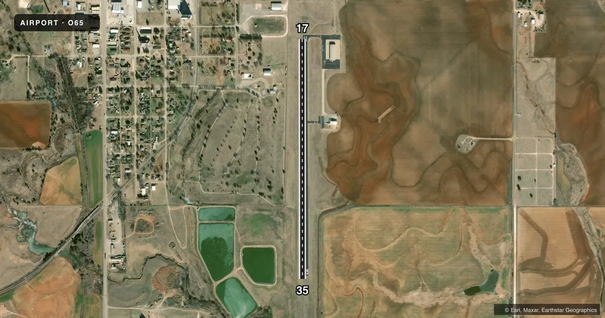
Runways & pattern
Full pagePattern entry · RWY 17
LEFT TRAFFICRunway end performance
| End | TORA | TODA | ASDA | LDA | VGSI | Approach lights | Obstruction |
|---|---|---|---|---|---|---|---|
| 17 | — | — | — | — | — | — | 34', tree, 752' from thr, 39' R of cntrln, slope 16 |
Declared distances in feet. TORA = takeoff run available, TODA = takeoff distance, ASDA = accelerate-stop, LDA = landing distance.
Airport sketch
Runways drawn to scale from FAA survey coordinates, rendered over satellite imagery. Not for navigation.
Approaches & charts
Services on the field
Fuel grades, oxygen, maintenance, ramp storage and lighting — as declared to the FAA by the airport operator.
Fuel & services
- Fuel
- Not available
- Oxygen (bottled)
- Not available
- Oxygen (bulk)
- Not available
- Airframe repair
- Not available
- Power plant repair
- Not available
- Other services
- AGRI
Ramp & ground
- Transient storage
- Tie-down
- Landing fee
- No fee published
- Customs
- Not available
- Lighting schedule
- SEE RMK
- Beacon schedule
- SS-SR
- Beacon
- White / Green (civil land)(WG)
- Wind indicator
- Lighted
- Segmented circle
- Yes
Fuel & FBOs
Cheapest 100LL and Jet A on the field and nearby. Always confirm with the FBO before taxi.
Airport notes
Surface conditions, obstructions, local procedures, lighting outages and other notes published with each FAA cycle.
General notes
- FOR CD CTC VANCE APCH AT 580-213-6765. WHEN VANCE APCH IS CLSD, CTC KANSAS CITY ARTCC AT 913-254-8508.
Lighting notes
- MIRL RWY 17/35 PRESET LOW INTENSITY, TO INCREASE INTENSITY - CTAF.
Other notes
- MANAGERCITY MANAGER.
VFR map & nearby airports
VFR sectional. Tap any ICAO chip to open that airport.
Key facts · O65
Answer card- ICAO
- O65
- Name
- CHRISTMAN AIRFIELD
- Location
- OKEENE, OKLAHOMA
- Elevation
- 1,207.5 ft MSL
- Traffic pattern altitude
- 2,207.5 ft MSL (1,000 AGL)
- Control tower
- Non-towered (use CTAF)
- Total runways
- 1
- Longest runway
- 17/35 · 3,000 ft
- Published ILS approaches
- 0
- Published frequencies
- 1
- Magnetic variation
- 7°
- Current flight rules
- VFR
- Current wind
- 240° at 11 kt
- Favored runway now
- RWY 17
Christman Airfield is in Okeene, Oklahoma. The field elevation is 1,207.5 ft MSL. It has one runway, 17/35, which is 3,000 ft of asphalt. There is no control tower. CTAF is 122.9.
No ILS approaches are published here. Pattern altitude is not published, so plan on the standard 1,000 ft AGL for light piston operations unless the current Chart Supplement says otherwise. That puts the traffic pattern at about 2,207.5 ft MSL based on the listed field elevation. The runway lights on 17/35 are preset to low intensity. Use the CTAF to request higher intensity if needed.
There are no on-field FBOs listed in the facts. Check with the airport operator or the FBO directly by phone before arrival if you need fuel or ramp details. For clearance delivery, the published remark says to contact Vance Approach at 580-213-6765. When Vance Approach is closed, contact Kansas City ARTCC at 913-254-8508. This is a non-towered field with a single 3,000 ft runway, so keep your radio work tight and verify current procedures before you go.