METAR & TAF 1S4
1S4 does not publish a METAR.
Showing the nearest reporting station: KJWG (WATONGA RGNL) · 30.4 NM away. Conditions at 1S4 may differ.
METAR · KJWG
Observed 17:15Z
KJWG 271715Z AUTO 20009KT 190V250 10SM CLR 36/17 A2993 RMK AO2 T03620174
- Wind
- 200° @ 9 kt
- Visibility
- 10 SM
- Temp / Dew
- 36°C / 17°C
- Altimeter
- 29.93 inHg
- Clouds
- CLR
- Density alt
- 4,673 ft
- Ceiling
- Unlimited
- Rules
- VFR
Airport info & contacts
Manager on record, flight service, ARTCC, attendance schedule and pattern altitude — published by the FAA and refreshed every 28 days.
Location
- From city
- 0 NM NW
- VFR sectional
- WICHITA
- ARTCC
- ZKC · KANSAS CITY
- NOTAM facility
- MLC (NOTAM-D)
Airport manager
- Name
- SKYLER SANDER
- Phone
- 580-922-4460
- Address
- PO BOX 1043, SEILING OK 73663
Flight service · Hours
- FSS MLC
- MC ALESTER1-800-WX-BRIEF
- Attendance
- Unattended
Frequencies
Tap any row to copy the frequency to your clipboard.
Runways & pattern
Full pagePattern entry · RWY 17
LEFT TRAFFICRunway end performance
| End | TORA | TODA | ASDA | LDA | VGSI | Approach lights | Obstruction |
|---|---|---|---|---|---|---|---|
| 35 | — | — | — | — | — | — | 41', tree, 206' from thr, 44' R of cntrln, slope 0 |
Declared distances in feet. TORA = takeoff run available, TODA = takeoff distance, ASDA = accelerate-stop, LDA = landing distance.
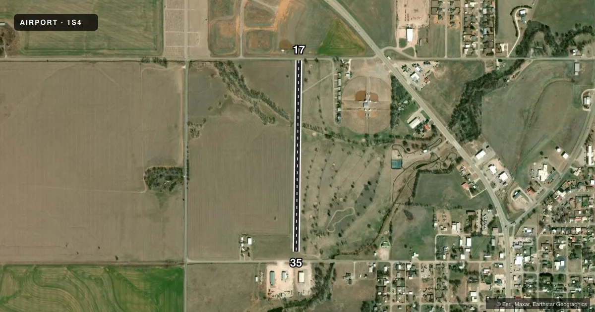
Airport sketch
Runways drawn to scale from FAA survey coordinates, rendered over satellite imagery. Not for navigation.
Approaches & charts
Services on the field
Fuel grades, oxygen, maintenance, ramp storage and lighting — as declared to the FAA by the airport operator.
Fuel & services
- Fuel
- Not available
- Oxygen (bottled)
- Not available
- Oxygen (bulk)
- Not available
- Airframe repair
- Not available
- Power plant repair
- Not available
Ramp & ground
- Transient storage
- Not published
- Landing fee
- No fee published
- Customs
- Not available
- Lighting schedule
- SS-SR
- Wind indicator
- Yes
- Segmented circle
- No
Fuel & FBOs
Cheapest 100LL and Jet A on the field and nearby. Always confirm with the FBO before taxi.
Airport notes
Surface conditions, obstructions, local procedures, lighting outages and other notes published with each FAA cycle.
General notes
- 496 FT UNLGTD TWR 18 NM S.
- FOR CD CTC KANSAS CITY ARTCC AT 913-254-8508.
Runway surface & condition
- 17/35LESS THAN 4000 LBS.
- 17/35NSTD DUE TO SPACING & HGT.
Approach & departure obstructions
- 1715 FT ROAD 20 FT FM THR; 46 FT TREE 90 FT L OF CNTRLN AT THR.
- 3515 FT ROAD 110 FT FM THR; 20 FT PLINE 140 FT FM THR 115 FT R & L OF CNTRLN; 37 FT TREE 120 FT R OF CNTRLN AT THR.
- 17EDGE MKD ONLY.
- 35EDGE MKD ONLY.
- 35APCH SLOPE 0:1 TREES, BLDGS, P-LINE, ROAD.
VFR map & nearby airports
VFR sectional. Tap any ICAO chip to open that airport.
Key facts · 1S4
Answer card- ICAO
- 1S4
- Name
- SEILING
- Location
- SEILING, OKLAHOMA
- Elevation
- 1,746 ft MSL
- Traffic pattern altitude
- 2,746 ft MSL (1,000 AGL)
- Control tower
- Non-towered (use CTAF)
- Total runways
- 1
- Longest runway
- 17/35 · 2,435 ft
- Published ILS approaches
- 0
- Published frequencies
- 1
- Magnetic variation
- 8°
- Current flight rules
- VFR
- Current wind
- 200° at 9 kt
- Favored runway now
- RWY 17
Seiling Airport (1S4) sits in Seiling, Oklahoma. The field elevation is 1,746 ft MSL. It has one runway, 17/35, which is 2,435 ft long with an asphalt surface. There is no control tower. CTAF is 122.9. No ILS approaches are published here.
Pattern altitude is not published. Use the standard 1,000 ft AGL pattern for light piston traffic unless the current Chart Supplement says otherwise. That puts the pattern at 2,746 ft MSL based on the listed field elevation. The airport sits in open country, so the main things to watch are runway length, obstacle clearance and density altitude on warm days.
The published remarks matter here. Runway 35 has trees, buildings, a power line and a road close in on the approach. Runway 17 also has a road near the threshold and a tree left of centerline. Runway lighting is nonstandard due to spacing and height. The runway markings are edge markings only. There is also a 496-foot unlighted tower 18 NM south. The gross weight limit for aircraft on runways 17 and 35 is less than 4,000 pounds. No on-field FBOs are listed. Contact the airport operator directly before arrival. Call the field on CTAF for current fuel and service options.