METAR & TAF KWWR
Current METAR
Observed 17:10Z
KWWR 271710Z AUTO 20006KT 10SM CLR 39/12 A2993 RMK AO2 T03850122
- Wind
- 200° @ 6 kt
- Visibility
- 10 SM
- Temp / Dew
- 39°C / 12°C
- Altimeter
- 29.93 inHg
- Clouds
- CLR
- Density alt
- 5,582 ft
- Ceiling
- Unlimited
- Rules
- VFR
Airport info & contacts
Manager on record, flight service, ARTCC, attendance schedule and pattern altitude — published by the FAA and refreshed every 28 days.
Location
- From city
- 6 NM W
- VFR sectional
- WICHITA
- ARTCC
- ZKC · KANSAS CITY
- NOTAM facility
- WWR (NOTAM-D)
Airport manager
- Name
- CHRIS AMES
- Phone
- 580-334-5786
- Address
- 1301 AIRPARK RD, WOODWARD OK 73801
Flight service · Hours
- FSS MLC
- MC ALESTER1-800-WX-BRIEF
- Attendance
- MON-FRI · 0800-1800
- SAT-SUN · 0800-1600
Frequencies
Tap any row to copy the frequency to your clipboard.
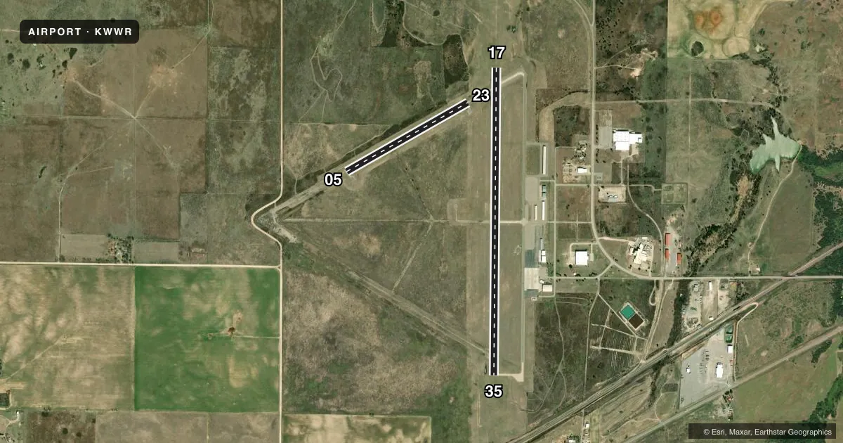
Runways & pattern
Full pagePattern entry · RWY 17
LEFT TRAFFIC| Runway | Heading (°M) | Length | Surface | Traffic |
|---|---|---|---|---|
| 17/35Favored | 172° / 352° | 5,502 ft | CONC | Standard L |
| 05/23 | 52° / 232° | 2,500 ft | ASPH | 23 R |
Runway end performance
| End | TORA | TODA | ASDA | LDA | VGSI | Approach lights | Obstruction |
|---|---|---|---|---|---|---|---|
| 17 | — | — | — | — | PAPI 4-box left(3°) | ODALS | — |
| 35 | — | — | — | — | PAPI 4-box left(3°) | — | — |
Declared distances in feet. TORA = takeoff run available, TODA = takeoff distance, ASDA = accelerate-stop, LDA = landing distance.
Airport sketch
Runways drawn to scale from FAA survey coordinates, rendered over satellite imagery. Not for navigation.
Approaches & charts
Services on the field
Fuel grades, oxygen, maintenance, ramp storage and lighting — as declared to the FAA by the airport operator.
Fuel & services
- Fuel
- 100LLA+
- Oxygen (bottled)
- Not available
- Oxygen (bulk)
- Not available
- Airframe repair
- Minor
- Power plant repair
- Minor
- Other services
- AFRT,INSTR,RNTL
Ramp & ground
- Transient storage
- Tie-down
- Hangar
- Landing fee
- No fee published
- Customs
- Not available
- Lighting schedule
- SEE RMK
- Beacon schedule
- SS-SR
- Beacon
- White / Green (civil land)(WG)
- Wind indicator
- Lighted
- Segmented circle
- Yes
Fuel & FBOs
Cheapest 100LL and Jet A on the field and nearby. Always confirm with the FBO before taxi.
Airport notes
Surface conditions, obstructions, local procedures, lighting outages and other notes published with each FAA cycle.
General notes
- ULTRALIGHT ACTIVITY ON & INVOF ARPT.
- TETRAHEDRON OTS.
- DEER & COYOTES ON & INVOF ARPT.
- FOR CD CTC KANSAS CITY ARTCC AT 913-254-8508.
- AFT HRS CTC 580-216-8233/ CALL OUT FEE.
- 24 HR. LOUNGE
- SELF SVC FUEL AVBL 24/7.
Lighting notes
- ACTVT & INCR INTST ODALS RWY 17; REIL RWY 35; MIRL RWY 05/23, 17/35 - CTAF. PAPI RWY 17 & 35 24-HR PHOTO CELL.
Approach & departure obstructions
- 05MKGS FADED & OBSCD.
- 23MKGS FADED & OBSCD.
Other notes
- PRE DATES THE ACT.
- 2UNATNDD SUN AND HOL.
VFR map & nearby airports
VFR sectional. Tap any ICAO chip to open that airport.
Key facts · KWWR
Answer card- ICAO
- KWWR
- Name
- WEST WOODWARD
- Location
- WOODWARD, OKLAHOMA
- Elevation
- 2,189 ft MSL
- Traffic pattern altitude
- 3,189 ft MSL (1,000 AGL)
- Control tower
- Non-towered (use CTAF)
- Total runways
- 2
- Longest runway
- 17/35 · 5,502 ft
- Published ILS approaches
- 0
- Published frequencies
- 2
- Magnetic variation
- 8°
- Current flight rules
- VFR
- Current wind
- 200° at 6 kt
- Favored runway now
- RWY 17
West Woodward Airport sits in Woodward, Oklahoma. Field elevation is 2,189 ft MSL. The airport has two runways. The longest is runway 17/35 at 5,502 ft. There is no control tower. CTAF and UNICOM are both 122.8. No ILS approaches are published here. The pattern altitude is not published, so use the standard 1,000 ft AGL for light piston traffic unless the current FAA Chart Supplement says otherwise.
The on-field FBO is West Woodward Airport. It carries 100LL and Jet A Prist. Self-serve fuel is available 24 hours a day, 7 days a week. The published remarks also note after-hours contact for service, with a call-out fee. Runway lighting is pilot controlled on CTAF. Runway 17 and 35 also have approach lighting and PAPI. Runway 35 has runway end identifier lights. The airport can be unattended on Sundays and holidays.
For a first-time arrival, watch for ultralight activity in and near the airport. Deer and coyotes are also noted on and near the field. Runway 05 and 23 markings are faded and obscured. The airport sits in open country, so expect a straightforward visual arrival. If you need clearance delivery, contact Kansas City ARTCC. Check the current FAA Chart Supplement for any changes before you go.