METAR & TAF KGAG
Current METAR
Observed 14:53Z
KGAG 271453Z AUTO 22011KT 10SM CLR 32/17 A2992 RMK AO2 SLP095 T03220167 51004
- Wind
- 220° @ 11 kt
- Visibility
- 10 SM
- Temp / Dew
- 32°C / 17°C
- Altimeter
- 29.92 inHg
- Clouds
- CLR
- Density alt
- 4,797 ft
- Ceiling
- Unlimited
- Rules
- VFR
Airport info & contacts
Manager on record, flight service, ARTCC, attendance schedule and pattern altitude — published by the FAA and refreshed every 28 days.
Location
- From city
- 2 NM SW
- VFR sectional
- WICHITA
- ARTCC
- ZKC · KANSAS CITY
- NOTAM facility
- GAG (NOTAM-D)
Airport manager
- Name
- ROBERT FORD
- Phone
- (580) 923-7727
- Address
- BOX 328, GAGE OK 73843
Flight service · Hours
- FSS MLC
- MC ALESTER1-800-WX-BRIEF
- Attendance
- Unattended
Frequencies
Tap any row to copy the frequency to your clipboard.
Runways & pattern
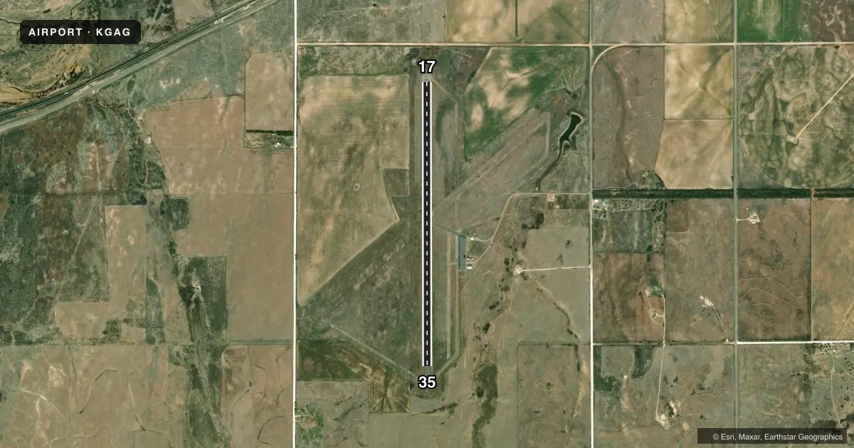
Full pagePattern entry · RWY 17
LEFT TRAFFICAirport sketch
Runways drawn to scale from FAA survey coordinates, rendered over satellite imagery. Not for navigation.
Approaches & charts
Services on the field
Fuel grades, oxygen, maintenance, ramp storage and lighting — as declared to the FAA by the airport operator.
Fuel & services
- Fuel
- Not available
- Oxygen (bottled)
- Not available
- Oxygen (bulk)
- Not available
- Airframe repair
- Not available
- Power plant repair
- Not available
Ramp & ground
- Transient storage
- Not published
- Landing fee
- No fee published
- Customs
- Not available
- Lighting schedule
- SEE RMK
- Beacon schedule
- SS-SR
- Beacon
- White / Green (civil land)(WG)
- Wind indicator
- Yes
- Segmented circle
- No
Fuel & FBOs
Cheapest 100LL and Jet A on the field and nearby. Always confirm with the FBO before taxi.
Airport notes
Surface conditions, obstructions, local procedures, lighting outages and other notes published with each FAA cycle.
General notes
- JET ACFT OVER 15000 LB NA.
- TWYS CLSD; USE MIDWAY STUB & BACK TAXI.
- ULTRALIGHT ACT ON & INVOF ARPT.
- FOR CD IF UNA TO CTC ON FSS FREQ, CTC KANSAS CITY ARTCC AT 913-254-8508.
Lighting notes
- ACTVT LIRL RWY 17/35 - 123.0.
Runway surface & condition
- 17/35NSTD; RWY 17 HAS NO THR LGTS; RWY 35 HAS FOUR THR LGTS.
VFR map & nearby airports
VFR sectional. Tap any ICAO chip to open that airport.
Key facts · KGAG
Answer card- ICAO
- KGAG
- Name
- GAGE
- Location
- GAGE, OKLAHOMA
- Elevation
- 2,223.2 ft MSL
- Traffic pattern altitude
- 3,223.2 ft MSL (1,000 AGL)
- Control tower
- Non-towered (use CTAF)
- Total runways
- 1
- Longest runway
- 17/35 · 5,033 ft
- Published ILS approaches
- 0
- Published frequencies
- 1
- Magnetic variation
- 8°
- Current flight rules
- VFR
- Current wind
- 220° at 11 kt
- Favored runway now
- RWY 17
Gage Airport sits in Gage, Oklahoma. The field elevation is 2,223.2 ft MSL. It has one runway, 17/35, which is 5,033 ft long and asphalt. There is no control tower. No ILS approaches are published here.
Pattern altitude is not published. Use the standard 1,000 ft AGL pattern unless the current Chart Supplement says otherwise. That puts the light-aircraft pattern at about 3,223 ft MSL. CTAF is 122.9. Runway lighting is a little unusual. Runway 17 has no threshold lights. Runway 35 has four threshold lights. Low intensity runway lights for 17/35 are activated on 123.0.
The published remarks matter here. Taxiways are closed, so plan on using the midway stub and back taxi. Jet aircraft over 15,000 pounds are not authorized. Ultralight activity is on and near the airport, so keep a sharp scan in the pattern and on taxi. If you cannot reach flight service for clearance delivery, Kansas City ARTCC is the backup contact listed in the Chart Supplement. There are no on-field FBOs listed, so call the airport operator or the field directly before arrival for current services.