METAR & TAF KBFK
KBFK does not publish a METAR.
Showing the nearest reporting station: KWWR (WEST WOODWARD) · 26.0 NM away. Conditions at KBFK may differ.
METAR · KWWR
Observed 17:10Z
KWWR 271710Z AUTO 20006KT 10SM CLR 39/12 A2993 RMK AO2 T03850122
- Wind
- 200° @ 6 kt
- Visibility
- 10 SM
- Temp / Dew
- 39°C / 12°C
- Altimeter
- 29.93 inHg
- Clouds
- CLR
- Density alt
- 5,127 ft
- Ceiling
- Unlimited
- Rules
- VFR
Airport info & contacts
Manager on record, flight service, ARTCC, attendance schedule and pattern altitude — published by the FAA and refreshed every 28 days.
Location
- From city
- 2 NM N
- VFR sectional
- WICHITA
- ARTCC
- ZKC · KANSAS CITY
- NOTAM facility
- MLC (NOTAM-D)
Airport manager
- Name
- BRIAN BOWLES
- Phone
- 580-735-2521
- Address
- 610 N. HOY ST., BUFFALO OK 73834
Flight service · Hours
- FSS MLC
- MC ALESTER1-800-WX-BRIEF
- Attendance
- Unattended
Frequencies
Tap any row to copy the frequency to your clipboard.
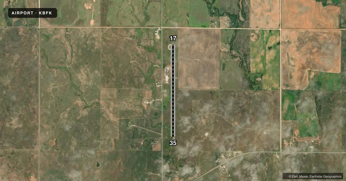
Runways & pattern
Full pagePattern entry · RWY 17
LEFT TRAFFICRunway end performance
| End | TORA | TODA | ASDA | LDA | VGSI | Approach lights | Obstruction |
|---|---|---|---|---|---|---|---|
| 17 | — | — | — | — | — | — | 34', pole, 705' from thr, 215' R of cntrln, slope 14 |
| 35 | — | — | — | — | — | — | 35', tree, 894' from thr, 256' R of cntrln, slope 19 |
Declared distances in feet. TORA = takeoff run available, TODA = takeoff distance, ASDA = accelerate-stop, LDA = landing distance.
Airport sketch
Runways drawn to scale from FAA survey coordinates, rendered over satellite imagery. Not for navigation.
Approaches & charts
Services on the field
Fuel grades, oxygen, maintenance, ramp storage and lighting — as declared to the FAA by the airport operator.
Fuel & services
- Fuel
- Not available
- Oxygen (bottled)
- Not available
- Oxygen (bulk)
- Not available
- Airframe repair
- Not available
- Power plant repair
- Not available
Ramp & ground
- Transient storage
- Hangar
- Landing fee
- No fee published
- Customs
- Not available
- Lighting schedule
- SEE RMK
- Beacon schedule
- SS-SR
- Beacon
- White / Green (civil land)(WG)
- Wind indicator
- Lighted
- Segmented circle
- No
Fuel & FBOs
Cheapest 100LL and Jet A on the field and nearby. Always confirm with the FBO before taxi.
Airport notes
Surface conditions, obstructions, local procedures, lighting outages and other notes published with each FAA cycle.
General notes
- FOR CD CTC KANSAS CITY ARTCC AT 913-254-8508.
Lighting notes
- ACTVT MIRL RY 17/35 - CTAF.
Other notes
- MANAGERCITY MANAGER.
VFR map & nearby airports
VFR sectional. Tap any ICAO chip to open that airport.
Key facts · KBFK
Answer card- ICAO
- KBFK
- Name
- BUFFALO MUNI
- Location
- BUFFALO, OKLAHOMA
- Elevation
- 1,822 ft MSL
- Traffic pattern altitude
- 2,822 ft MSL (1,000 AGL)
- Control tower
- Non-towered (use CTAF)
- Total runways
- 1
- Longest runway
- 17/35 · 4,000 ft
- Published ILS approaches
- 0
- Published frequencies
- 1
- Magnetic variation
- 8°
- Current flight rules
- VFR
- Current wind
- 200° at 6 kt
- Favored runway now
- RWY 17
Buffalo Muni is in Buffalo, Oklahoma. The field elevation is 1,822 ft MSL. It has one runway, 17/35, at 4,000 ft asphalt. There is no control tower. CTAF is 122.9.
No ILS approaches are published here. Pattern altitude is not published, so use the standard 1,000 ft AGL unless current local guidance says otherwise. That puts the light piston pattern at 2,822 ft MSL based on the field elevation. Runway lights on 17/35 are medium intensity. They are activated using the CTAF.
There are no on-field FBOs listed in the facts, so verify services with the airport operator before you go. The published remarks also note that clearance delivery is handled through Kansas City Center at 913-254-8508. This is a non-towered field in open country. Expect to self-announce clearly on CTAF and watch for other traffic. The elevation is high enough that density altitude can matter on warm days, so plan performance with care.