METAR & TAF KMDF
KMDF does not publish a METAR.
Showing the nearest reporting station: KWWR (WEST WOODWARD) · 16.1 NM away. Conditions at KMDF may differ.
METAR · KWWR
Observed 18:30Z
KWWR 271830Z AUTO 18010KT 10SM CLR 40/11 A2991 RMK AO2 T03950114
- Wind
- 180° @ 10 kt
- Visibility
- 10 SM
- Temp / Dew
- 40°C / 11°C
- Altimeter
- 29.91 inHg
- Clouds
- CLR
- Density alt
- 5,455 ft
- Ceiling
- Unlimited
- Rules
- VFR
Airport info & contacts
Manager on record, flight service, ARTCC, attendance schedule and pattern altitude — published by the FAA and refreshed every 28 days.
Location
- From city
- 3 NM N
- VFR sectional
- WICHITA
- ARTCC
- ZKC · KANSAS CITY
- NOTAM facility
- MLC (NOTAM-D)
Airport manager
- Name
- BOBBY KEHN
- Phone
- 580-994-5924
- Address
- 214 S. MAIN, PO BOX 157, PO BOX 157, MOORELAND OK 73852
Flight service · Hours
- FSS MLC
- MC ALESTER1-800-WX-BRIEF
- Attendance
- Unattended
Frequencies
Tap any row to copy the frequency to your clipboard.
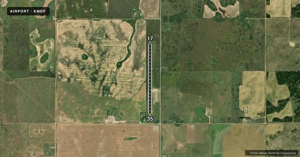
Runways & pattern
Full pagePattern entry · RWY 17
LEFT TRAFFICRunway end performance
| End | TORA | TODA | ASDA | LDA | VGSI | Approach lights | Obstruction |
|---|---|---|---|---|---|---|---|
| 35 | — | — | — | — | — | — | 34', trees, 288' from thr, 202' R of cntrln, slope 2 |
Declared distances in feet. TORA = takeoff run available, TODA = takeoff distance, ASDA = accelerate-stop, LDA = landing distance.
Airport sketch
Runways drawn to scale from FAA survey coordinates, rendered over satellite imagery. Not for navigation.
Approaches & charts
Services on the field
Fuel grades, oxygen, maintenance, ramp storage and lighting — as declared to the FAA by the airport operator.
Fuel & services
- Fuel
- Not available
- Oxygen (bottled)
- Not available
- Oxygen (bulk)
- Not available
- Airframe repair
- Not available
- Power plant repair
- Not available
Ramp & ground
- Transient storage
- Tie-down
- Landing fee
- No fee published
- Customs
- Not available
- Lighting schedule
- SEE RMK
- Beacon schedule
- SS-SR
- Beacon
- White / Green (civil land)(WG)
- Wind indicator
- Lighted
- Segmented circle
- No
Fuel & FBOs
Cheapest 100LL and Jet A on the field and nearby. Always confirm with the FBO before taxi.
Airport notes
Surface conditions, obstructions, local procedures, lighting outages and other notes published with each FAA cycle.
General notes
- TWY A CLSD INDEFLY; BACK TAXI REQUIRED FOR RY 17/35.
- FOR CD CTC KANSAS CITY ARTCC AT 913-254-8508.
Lighting notes
- ROTG BCN OTS INDEFLY.
- DUSK - DAWN ACTVT MIRL RY 17/35 - CTAF.
Approach & departure obstructions
- 3534 FT TREES 288 FT FM RWY END, 202 FT LEFT OF CNTRLN.
Other notes
- 2FOR AIRPORT ATTENDANT CALL DARWIN LOOMIS 580-334-5842
- MANAGERCITY MANAGER.
- 17/35SVR DEPRESSION SOUTHEAST OF RWY 35 500 FT FM APCH END.
VFR map & nearby airports
VFR sectional. Tap any ICAO chip to open that airport.
Key facts · KMDF
Answer card- ICAO
- KMDF
- Name
- MOORELAND MUNI
- Location
- MOORELAND, OKLAHOMA
- Elevation
- 1,970 ft MSL
- Traffic pattern altitude
- 2,970 ft MSL (1,000 AGL)
- Control tower
- Non-towered (use CTAF)
- Total runways
- 1
- Longest runway
- 17/35 · 3,500 ft
- Published ILS approaches
- 0
- Published frequencies
- 2
- Magnetic variation
- 8°
- Current flight rules
- VFR
- Current wind
- 180° at 10 kt
- Favored runway now
- RWY 17
Mooreland Muni sits in Mooreland, Oklahoma. The field elevation is 1,970 ft MSL. It has one runway. Runway 17/35 is 3,500 ft of asphalt, which is the longest runway on the field.
This is an untowered airport. CTAF and UNICOM are both 122.8. No ILS approaches are published. The pattern altitude is not published in the facts, so use the standard 1,000 ft AGL pattern unless the current FAA Chart Supplement says otherwise. That puts the light piston pattern at 2,970 ft MSL based on the listed field elevation.
There are no on-field FBOs listed in the facts. Contact the airport operator directly before arrival, or call the field on CTAF or UNICOM for current FBO availability. The published remarks also matter here. Taxiway A is closed indefinitely, so back taxi is required on runway 17/35. The runway lights on 17/35 are activated by CTAF from dusk to dawn. The rotating beacon is out of service indefinitely. There is also a tree obstruction near the runway 35 end, plus a severe depression southeast of runway 35. Plan your arrival with those items in mind. For clearance delivery, Kansas City ARTCC handles it.