METAR & TAF 1K5
1K5 does not publish a METAR.
Showing the nearest reporting station: KAVK (ALVA RGNL) · 15.0 NM away. Conditions at 1K5 may differ.
METAR · KAVK
Observed 17:15Z
KAVK 271715Z AUTO 21009KT 10SM CLR 38/18 A2985 RMK A01
- Wind
- 210° @ 9 kt
- Visibility
- 10 SM
- Temp / Dew
- 38°C / 18°C
- Altimeter
- 29.85 inHg
- Clouds
- CLR
- Density alt
- 4,762 ft
- Ceiling
- Unlimited
- Rules
- VFR
Airport info & contacts
Manager on record, flight service, ARTCC, attendance schedule and pattern altitude — published by the FAA and refreshed every 28 days.
Location
- From city
- 1 NM SE
- VFR sectional
- WICHITA
- ARTCC
- ZKC · KANSAS CITY
- NOTAM facility
- MLC (NOTAM-D)
Airport manager
- Name
- SUE HUGHES
- Phone
- (720) 256-3442
- Address
- 2367 WAYNOKA ST, WAYNOKA OK 73860
Flight service · Hours
- FSS MLC
- MC ALESTER1-800-WX-BRIEF
- Attendance
- Unattended
Frequencies
Tap any row to copy the frequency to your clipboard.
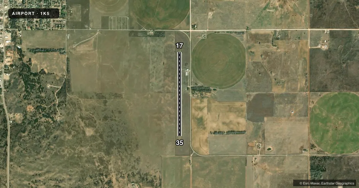
Runways & pattern
Full pagePattern entry · RWY 17
LEFT TRAFFICAirport sketch
Runways drawn to scale from FAA survey coordinates, rendered over satellite imagery. Not for navigation.
Approaches & charts
Services on the field
Fuel grades, oxygen, maintenance, ramp storage and lighting — as declared to the FAA by the airport operator.
Fuel & services
- Fuel
- Not available
- Oxygen (bottled)
- Not available
- Oxygen (bulk)
- Not available
- Airframe repair
- Not available
- Power plant repair
- Not available
Ramp & ground
- Transient storage
- Tie-down
- Landing fee
- No fee published
- Customs
- Not available
- Lighting schedule
- SEE RMK
- Beacon schedule
- SS-SR
- Beacon
- White / Green (civil land)(WG)
- Wind indicator
- Lighted
- Segmented circle
- No
Fuel & FBOs
Cheapest 100LL and Jet A on the field and nearby. Always confirm with the FBO before taxi.
Airport notes
Surface conditions, obstructions, local procedures, lighting outages and other notes published with each FAA cycle.
General notes
- PARALLEL TWY CLSD INDEFLY.
- FOR CD CTC KANSAS CITY ARTCC AT 913-254-8508.
Lighting notes
- ACTIVATE MIRL RY 17/35 DUSK-DAWN - CTAF
Other notes
- MANAGERAIRPORT BOARD CHAIRWOMAN
VFR map & nearby airports
VFR sectional. Tap any ICAO chip to open that airport.
Key facts · 1K5
Answer card- ICAO
- 1K5
- Name
- WAYNOKA MUNI
- Location
- WAYNOKA, OKLAHOMA
- Elevation
- 1,544.4 ft MSL
- Traffic pattern altitude
- 2,544.4 ft MSL (1,000 AGL)
- Control tower
- Non-towered (use CTAF)
- Total runways
- 1
- Longest runway
- 17/35 · 3,532 ft
- Published ILS approaches
- 0
- Published frequencies
- 1
- Magnetic variation
- 8°
- Current flight rules
- VFR
- Current wind
- 210° at 9 kt
- Favored runway now
- RWY 17
Waynoka Muni sits in Waynoka, Oklahoma. The field elevation is 1,544.4 ft MSL. It has one runway. Runway 17/35 is 3,532 ft long with an asphalt surface. There is no control tower. CTAF is 122.9.
No ILS approaches are published here. Pattern altitude is not published, so use the standard 1,000 ft AGL unless the current FAA Chart Supplement says otherwise. That puts the light piston pattern at about 2,544 ft MSL based on the listed field elevation. The magnetic variation is 8°. The published runway headings are 180° and 360° magnetic.
The Chart Supplement notes that the parallel taxiway is closed indefinitely. Plan for that on the ground. The runway lights on 17/35 are medium intensity. They are activated from dusk to dawn using the common traffic advisory frequency. For clearance delivery, contact Kansas City Air Route Traffic Control Center at 913-254-8508. No on-field FBOs are listed, so verify fuel and service options with the airport operator before you go. For a first-time arrival, the main things to watch are the non-towered traffic flow, the taxiway closure and the lack of published instrument approach support.