METAR & TAF 6K4
6K4 does not publish a METAR.
Showing the nearest reporting station: KJWG (WATONGA RGNL) · 25.8 NM away. Conditions at 6K4 may differ.
METAR · KJWG
Observed 15:55Z
KJWG 271555Z AUTO 19011KT 10SM CLR 34/18 A2994 RMK AO2 T03390177
- Wind
- 190° @ 11 kt
- Visibility
- 10 SM
- Temp / Dew
- 34°C / 18°C
- Altimeter
- 29.94 inHg
- Clouds
- CLR
- Density alt
- 3,835 ft
- Ceiling
- Unlimited
- Rules
- VFR
Airport info & contacts
Manager on record, flight service, ARTCC, attendance schedule and pattern altitude — published by the FAA and refreshed every 28 days.
Location
- From city
- 1 NM N
- VFR sectional
- WICHITA
- ARTCC
- ZKC · KANSAS CITY
- NOTAM facility
- MLC (NOTAM-D)
Airport manager
- Name
- MATTHEW REGIER
- Phone
- 580-227-3788
- Address
- 224 E. OKLAHOMA AVENUE, FAIRVIEW OK 73737
Flight service · Hours
- FSS MLC
- MC ALESTER1-800-WX-BRIEF
- Attendance
- MON-SAT · DALGT
Frequencies
Tap any row to copy the frequency to your clipboard.
Runways & pattern
Full pagePattern entry · RWY 17
LEFT TRAFFICRunway end performance
| End | TORA | TODA | ASDA | LDA | VGSI | Approach lights | Obstruction |
|---|---|---|---|---|---|---|---|
| 35 | — | — | — | — | — | — | 45', trees, 512' from thr, 261' R of cntrln, slope 6 |
Declared distances in feet. TORA = takeoff run available, TODA = takeoff distance, ASDA = accelerate-stop, LDA = landing distance.
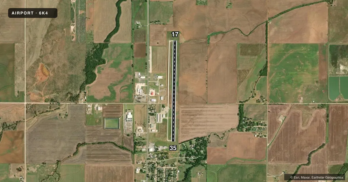
Airport sketch
Runways drawn to scale from FAA survey coordinates, rendered over satellite imagery. Not for navigation.
Approaches & charts
Services on the field
Fuel grades, oxygen, maintenance, ramp storage and lighting — as declared to the FAA by the airport operator.
Fuel & services
- Fuel
- 100LL
- Oxygen (bottled)
- Not available
- Oxygen (bulk)
- Not available
- Airframe repair
- Not available
- Power plant repair
- Not available
- Other services
- AGRI
Ramp & ground
- Transient storage
- Tie-down
- Landing fee
- No fee published
- Customs
- Not available
- Lighting schedule
- SS-SR
- Beacon schedule
- SS-SR
- Beacon
- White / Green (civil land)(WG)
- Wind indicator
- Lighted
- Segmented circle
- Yes
Fuel & FBOs
Cheapest 100LL and Jet A on the field and nearby. Always confirm with the FBO before taxi.
Airport notes
Surface conditions, obstructions, local procedures, lighting outages and other notes published with each FAA cycle.
General notes
- FOR CD CTC VANCE APCH AT 580-213-6765. WHEN VANCE APCH IS CLSD, CTC KANSAS CITY ARTCC AT 913-254-8508.
Fuel notes
- 100LLAVBL DURG WINT MONTHS.
Approach & departure obstructions
- 17TREE 1037 FT FM RWY END 36 FT LEFT OF APCH CREATES 15:1 APCH CLC SLOPE.
VFR map & nearby airports
VFR sectional. Tap any ICAO chip to open that airport.
Key facts · 6K4
Answer card- ICAO
- 6K4
- Name
- FAIRVIEW MUNI
- Location
- FAIRVIEW, OKLAHOMA
- Elevation
- 1,273.8 ft MSL
- Traffic pattern altitude
- 2,273.8 ft MSL (1,000 AGL)
- Control tower
- Non-towered (use CTAF)
- Total runways
- 1
- Longest runway
- 17/35 · 4,400 ft
- Published ILS approaches
- 0
- Published frequencies
- 4
- Magnetic variation
- 4°
- Current flight rules
- VFR
- Current wind
- 190° at 11 kt
- Favored runway now
- RWY 17
Fairview Muni sits in Fairview, Oklahoma. The field elevation is 1,273.8 ft MSL. It has one runway, 17/35, which is 4,400 ft long with asphalt-concrete pavement. There is no control tower. No ILS approaches are published here.
Pattern altitude is not published. Use the standard 1,000 ft AGL for light piston traffic unless the current Chart Supplement says otherwise. The airport uses CTAF 122.8 and UNICOM 122.8. For clearance delivery, contact Vance Approach at 580-213-6765. When Vance Approach is closed, contact Kansas City ARTCC at 913-254-8508.
The on-field FBO is Fairview Municipal Airport. It carries 100LL. Published remarks also note a tree near the approach end of runway 17. It sits 1,037 ft from the runway end and 36 ft left of the approach path. That makes the first part of the approach worth a careful look, especially if you are arriving low or in reduced visibility. 100LL is available during winter months.
For a first-time arrival, the main things are simple. This is an uncontrolled field with a single runway and no published ILS. Check the current Chart Supplement for any changes before you go. If you need current airport details or fuel availability, call the airport operator or the FBO directly by phone.