METAR & TAF 4O5
4O5 does not publish a METAR.
Showing the nearest reporting station: KAVK (ALVA RGNL) · 15.1 NM away. Conditions at 4O5 may differ.
METAR · KAVK
Observed 16:55Z
KAVK 271655Z AUTO 19012KT 10SM CLR 37/18 A2986 RMK A01
- Wind
- 190° @ 12 kt
- Visibility
- 10 SM
- Temp / Dew
- 37°C / 18°C
- Altimeter
- 29.86 inHg
- Clouds
- CLR
- Density alt
- 4,176 ft
- Ceiling
- Unlimited
- Rules
- VFR
Airport info & contacts
Manager on record, flight service, ARTCC, attendance schedule and pattern altitude — published by the FAA and refreshed every 28 days.
Location
- From city
- 2 NM N
- VFR sectional
- WICHITA
- ARTCC
- ZKC · KANSAS CITY
- NOTAM facility
- MLC (NOTAM-D)
Airport manager
- Name
- CHAD ROACH
- Phone
- 580-596-3052
- Address
- 112 N GRAND, CHEROKEE OK 73728
Flight service · Hours
- FSS MLC
- MC ALESTER1-800-WX-BRIEF
- Attendance
- Unattended
Frequencies
Tap any row to copy the frequency to your clipboard.
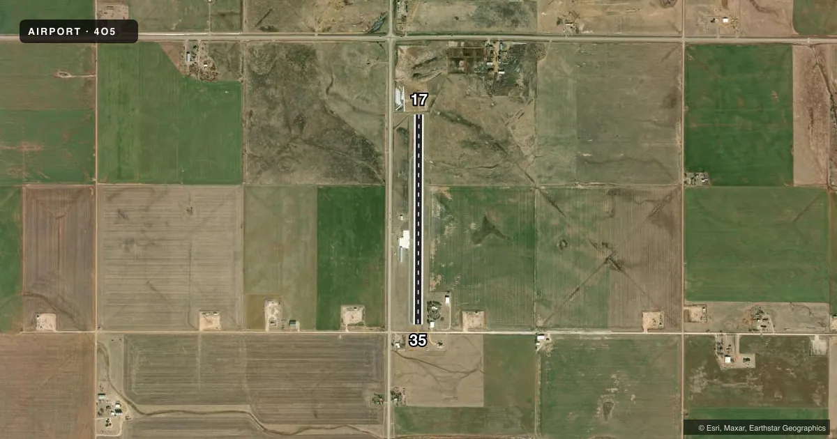
Runways & pattern
Full pagePattern entry · RWY 17
LEFT TRAFFICAirport sketch
Runways drawn to scale from FAA survey coordinates, rendered over satellite imagery. Not for navigation.
Approaches & charts
Services on the field
Fuel grades, oxygen, maintenance, ramp storage and lighting — as declared to the FAA by the airport operator.
Fuel & services
- Fuel
- 100LL
- Oxygen (bottled)
- Not available
- Oxygen (bulk)
- Not available
- Airframe repair
- Not available
- Power plant repair
- Not available
Ramp & ground
- Transient storage
- Tie-down
- Landing fee
- No fee published
- Customs
- Not available
- Lighting schedule
- SEE RMK
- Beacon schedule
- SS-SR
- Beacon
- White / Green (civil land)(WG)
- Wind indicator
- Lighted
- Segmented circle
- No
Fuel & FBOs
Cheapest 100LL and Jet A on the field and nearby. Always confirm with the FBO before taxi.
Airport notes
Surface conditions, obstructions, local procedures, lighting outages and other notes published with each FAA cycle.
General notes
- FOR CD CTC VANCE APCH AT 580-213-6765. WHEN VANCE APCH IS CLSD, CTC KANSAS CITY ARTCC AT 913-254-8508.
Lighting notes
- SS-SR ACTVT MIRL RY 17/35 - CTAF.
Approach & departure obstructions
- 178 FT FENCE 50 FT FM RWY END 47:1 CLNC SLOPE TO DTHR.
- 3515' ROAD 130' FM RWY END CROSSES EXT CL; 8' FENCE 50' FM RWY END 47:1 CLC SLOPE TO DISP THRLD
VFR map & nearby airports
VFR sectional. Tap any ICAO chip to open that airport.
Key facts · 4O5
Answer card- ICAO
- 4O5
- Name
- CHEROKEE MUNI
- Location
- CHEROKEE, OKLAHOMA
- Elevation
- 1,179 ft MSL
- Traffic pattern altitude
- 2,179 ft MSL (1,000 AGL)
- Control tower
- Non-towered (use CTAF)
- Total runways
- 1
- Longest runway
- 17/35 · 3,770 ft
- Published ILS approaches
- 0
- Published frequencies
- 1
- Magnetic variation
- 7°
- Current flight rules
- VFR
- Current wind
- 190° at 12 kt
- Favored runway now
- RWY 17
Cherokee Muni is in Cherokee, Oklahoma. The field elevation is 1,179 ft MSL. It has one runway. Runway 17/35 is 3,770 ft of asphalt, so plan performance with that length in mind. There is no control tower. CTAF is 122.9.
No ILS approaches are published here. Pattern altitude is not published, so use standard pattern planning for light piston aircraft at 1,000 ft AGL. That puts the pattern at 2,179 ft MSL based on the field elevation. Check the current FAA Chart Supplement before you go if you want the latest approach picture or any local notes.
Published remarks matter here. Medium intensity runway lights on 17/35 are switched on from sunset to sunrise on CTAF. There is also an 8-foot fence near the departure end of runway 17 with a noted climb gradient issue. Runway 35 has a road crossing the extended centerline near the end, plus an 8-foot fence near the runway end with a displaced-threshold note. There are no on-field FBOs listed, so contact the airport operator directly or call the field on CTAF for current services before arrival.