METAR & TAF K51
K51 does not publish a METAR.
Showing the nearest reporting station: KANY (ANTHONY MUNI) · 23.3 NM away. Conditions at K51 may differ.
METAR · KANY
Observed 12:35Z
KANY 271235Z AUTO 17008KT 10SM CLR 25/19 A2987 RMK AO2
- Wind
- 170° @ 8 kt
- Visibility
- 10 SM
- Temp / Dew
- 25°C / 19°C
- Altimeter
- 29.87 inHg
- Clouds
- CLR
- Density alt
- 3,183 ft
- Ceiling
- Unlimited
- Rules
- VFR
Airport info & contacts
Manager on record, flight service, ARTCC, attendance schedule and pattern altitude — published by the FAA and refreshed every 28 days.
Location
- From city
- 3 NM SE
- VFR sectional
- WICHITA
- ARTCC
- ZKC · KANSAS CITY
- NOTAM facility
- ICT (NOTAM-D)
Airport manager
- Name
- KANDI WILLIAMS
- Phone
- 620-886-3908
- Address
- 114 W 1ST ST., MEDICINE LODGE KS 67104
Flight service · Hours
- FSS ICT
- WICHITA1-800-WX-BRIEF
- Attendance
- Unattended
Frequencies
Tap any row to copy the frequency to your clipboard.
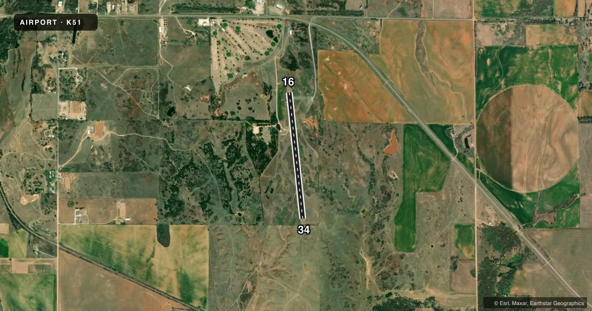
Runways & pattern
Full pagePattern entry · RWY 16
LEFT TRAFFICRunway end performance
| End | TORA | TODA | ASDA | LDA | VGSI | Approach lights | Obstruction |
|---|---|---|---|---|---|---|---|
| 16 | 3,200' | 3,200' | — | — | — | — | 40', tree, 745' from thr, 20' R of cntrln, slope 13 |
| 34 | 3,200' | 3,200' | — | — | — | — | — |
Declared distances in feet. TORA = takeoff run available, TODA = takeoff distance, ASDA = accelerate-stop, LDA = landing distance.
Airport sketch
Runways drawn to scale from FAA survey coordinates, rendered over satellite imagery. Not for navigation.
Approaches & charts
Services on the field
Fuel grades, oxygen, maintenance, ramp storage and lighting — as declared to the FAA by the airport operator.
Fuel & services
- Fuel
- Not available
- Airframe repair
- Not available
- Power plant repair
- Not available
Ramp & ground
- Transient storage
- Tie-down
- Landing fee
- No fee published
- Lighting schedule
- SS-SR
- Beacon schedule
- SS-SR
- Beacon
- White / Green (civil land)(WG)
- Wind indicator
- Lighted
- Segmented circle
- No
Fuel & FBOs
Cheapest 100LL and Jet A on the field and nearby. Always confirm with the FBO before taxi.
Airport notes
Surface conditions, obstructions, local procedures, lighting outages and other notes published with each FAA cycle.
General notes
- AWOS 398 FT. LEFT RY 16
- FOR CD CTC KANSAS CITY ARTCC AT 913-254-8508.
- 25' WIDE BY 430' LONG ASPH TWY 140' SOUTH OF THE AER 16. TO A 80' X 145' APRON
Approach & departure obstructions
- 345 FT FENCE 160 FT FROM RY END.
Other notes
- EXISTED PRIOR TO 1959.
- 1FOR SERVICE & ARPT INFO CALL SHERIFF 620-886-5678.
VFR map & nearby airports
VFR sectional. Tap any ICAO chip to open that airport.
Key facts · K51
Answer card- ICAO
- K51
- Name
- MEDICINE LODGE
- Location
- MEDICINE LODGE, KANSAS
- Elevation
- 1,549 ft MSL
- Traffic pattern altitude
- 2,549 ft MSL (1,000 AGL)
- Control tower
- Non-towered (use CTAF)
- Total runways
- 1
- Longest runway
- 16/34 · 3,200 ft
- Published ILS approaches
- 0
- Published frequencies
- 1
- Magnetic variation
- 7°
- Current flight rules
- VFR
- Current wind
- 170° at 8 kt
- Favored runway now
- RWY 16
Medicine Lodge Airport (K51) sits in Medicine Lodge, Kansas. Field elevation is 1,549 ft MSL. The airport has one runway. Runway 16/34 is 3,200 ft long with an asphalt surface. The field is non-towered. CTAF is 122.9.
No ILS approaches are published here. Pattern altitude is not published, so use the standard 1,000 ft AGL pattern unless local guidance says otherwise. That puts the light piston pattern at about 2,549 ft MSL. The runway headings are magnetic. Runway 16 is 174°. Runway 34 is 354°.
There are no on-field FBOs listed in the facts. Contact the airport operator or the field directly before arrival for current fuel and service options. Published remarks note a taxiway south of runway 16 that leads to the apron. They also note a 5-foot fence near the runway end of 34. That is worth keeping in mind on short final. The airport also has an AWOS located left of runway 16. For clearance delivery, contact Kansas City ARTCC. For airport information, the sheriff is listed in the Chart Supplement. This is a small Kansas field with no tower. Plan your arrival. Monitor CTAF closely. Verify current local details before you go.