METAR & TAF KANY
Current METAR
Observed 14:55Z
KANY 271455Z AUTO 20009KT 10SM CLR 32/19 A2988 RMK AO2
- Wind
- 200° @ 9 kt
- Visibility
- 10 SM
- Temp / Dew
- 32°C / 19°C
- Altimeter
- 29.88 inHg
- Clouds
- CLR
- Density alt
- 3,755 ft
- Ceiling
- Unlimited
- Rules
- VFR
Airport info & contacts
Manager on record, flight service, ARTCC, attendance schedule and pattern altitude — published by the FAA and refreshed every 28 days.
Location
- From city
- 3 NM NW
- VFR sectional
- WICHITA
- ARTCC
- ZKC · KANSAS CITY
- NOTAM facility
- ICT (NOTAM-D)
Airport manager
- Name
- CYNDRA KASTENS
- Phone
- 620-842-5434
- Address
- 124 S BLUFF, P O BOX 504, ANTHONY KS 67003
Flight service · Hours
- FSS ICT
- WICHITA1-800-WX-BRIEF
- Attendance
- Unattended
Frequencies
Tap any row to copy the frequency to your clipboard.
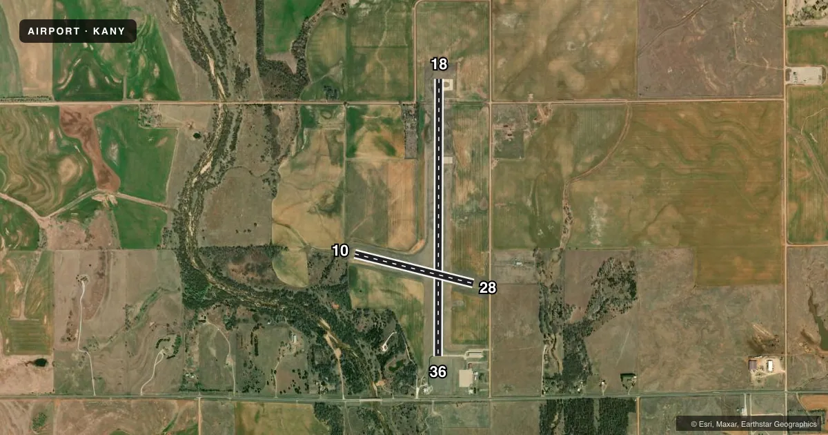
Runways & pattern
Full pagePattern entry · RWY 18
LEFT TRAFFIC| Runway | Heading (°M) | Length | Surface | Traffic |
|---|---|---|---|---|
| 18/36Favored | 175° / 355° | 5,002 ft | CONC | Standard L |
| 10/28 | 99° / 279° | 2,212 ft | TURF | Standard L |
Runway end performance
| End | TORA | TODA | ASDA | LDA | VGSI | Approach lights | Obstruction |
|---|---|---|---|---|---|---|---|
| 18 | — | — | — | — | PAPI 2-box left(3°) | — | — |
| 36 | — | — | — | — | PAPI 2-box left(3°) | — | 34', tree, 894' from thr, 0' R of cntrln, slope 20 |
| 10 | — | — | — | — | — | — | 5', trees, 111' from thr, 125' R of cntrln, slope 22 |
| 28 | — | — | — | — | — | — | 13', road, 300' from thr, 155' R of cntrln, slope 23 |
Declared distances in feet. TORA = takeoff run available, TODA = takeoff distance, ASDA = accelerate-stop, LDA = landing distance.
Airport sketch
Runways drawn to scale from FAA survey coordinates, rendered over satellite imagery. Not for navigation.
Approaches & charts
Services on the field
Fuel grades, oxygen, maintenance, ramp storage and lighting — as declared to the FAA by the airport operator.
Fuel & services
- Fuel
- 100LL
- Other services
- AGRI
Ramp & ground
- Transient storage
- Tie-down
- Hangar
- Landing fee
- No fee published
- Lighting schedule
- SEE RMK
- Beacon schedule
- SS-SR
- Beacon
- White / Green (civil land)(WG)
- Wind indicator
- Lighted
- Segmented circle
- Yes
Fuel & FBOs
Cheapest 100LL and Jet A on the field and nearby. Always confirm with the FBO before taxi.
Airport notes
Surface conditions, obstructions, local procedures, lighting outages and other notes published with each FAA cycle.
General notes
- TERMINAL BLDG ACCESS CODE 134.
- FOR CD IF UNA TO CTC ON FSS FREQ, CTC WICHITA APPCH AT 316-350-1520
Lighting notes
- LIRL RWY 18/36 PRESET LOW INTST; TO INCR INTST AND ACTVT PAPI RWY 18 & 36 - CTAF.
Fuel notes
- 100LLFUEL SELF SVC.
Runway surface & condition
- 10/28MOWED 300 FT WIDE.
Other notes
- EXISTED PRIOR TO 1959.
- 10/28SOFT AFTER RAIN.
VFR map & nearby airports
VFR sectional. Tap any ICAO chip to open that airport.
Key facts · KANY
Answer card- ICAO
- KANY
- Name
- ANTHONY MUNI
- Location
- ANTHONY, KANSAS
- Elevation
- 1,343.1 ft MSL
- Traffic pattern altitude
- 2,343.1 ft MSL (1,000 AGL)
- Control tower
- Non-towered (use CTAF)
- Total runways
- 2
- Longest runway
- 18/36 · 5,002 ft
- Published ILS approaches
- 0
- Published frequencies
- 4
- Magnetic variation
- 5°
- Current flight rules
- VFR
- Current wind
- 200° at 9 kt
- Favored runway now
- RWY 18
Anthony Muni is in Anthony, Kansas. The field elevation is 1,343.1 ft MSL. It has two runways. The longest is runway 18/36 at 5,002 ft of concrete. Runway 10/28 is 2,212 ft of turf. There is no control tower. No ILS approaches are published. Pattern altitude is not published, so light piston pilots should plan on the standard 1,000 ft AGL unless the current Chart Supplement says otherwise.
The on-field FBO is Anthony Municipal Airport. It carries 100LL. Fuel is self-serve. The airport remarks also note that runway 18/36 has low-intensity edge lighting preset. Use CTAF to increase intensity. Use CTAF to activate the PAPI for 18 and 36. Runway 10/28 is mowed to 300 ft wide. It can be soft after rain, so check field conditions before using the turf.
This is an uncontrolled field with Wichita approach services listed for IFR coordination. If you need clearance delivery and cannot reach flight service, contact Wichita Approach. The airport sits in open Kansas country with no published ILS, so plan your arrival with current weather, runway condition and wind in mind. The terminal building access code is published in the Chart Supplement. Verify it before you go.