METAR & TAF 2K8
2K8 does not publish a METAR.
Showing the nearest reporting station: KANY (ANTHONY MUNI) · 16.8 NM away. Conditions at 2K8 may differ.
METAR · KANY
Observed 18:35Z
KANY 261835Z AUTO 19012KT 10SM CLR 39/21 A2991 RMK AO2
- Wind
- 190° @ 12 kt
- Visibility
- 10 SM
- Temp / Dew
- 39°C / 21°C
- Altimeter
- 29.91 inHg
- Clouds
- CLR
- Density alt
- 4,478 ft
- Ceiling
- Unlimited
- Rules
- VFR
Airport info & contacts
Manager on record, flight service, ARTCC, attendance schedule and pattern altitude — published by the FAA and refreshed every 28 days.
Location
- From city
- 1 NM NE
- VFR sectional
- WICHITA
- ARTCC
- ZKC · KANSAS CITY
- NOTAM facility
- ICT (NOTAM-D)
Airport manager
- Name
- DAVE SPENCE
- Phone
- (620) 435-6442
- Address
- 421 SO. MAIN ST, ARGONIA KS 67004-9758
Flight service · Hours
- FSS ICT
- WICHITA1-800-WX-BRIEF
- Attendance
- Unattended
Frequencies
Tap any row to copy the frequency to your clipboard.
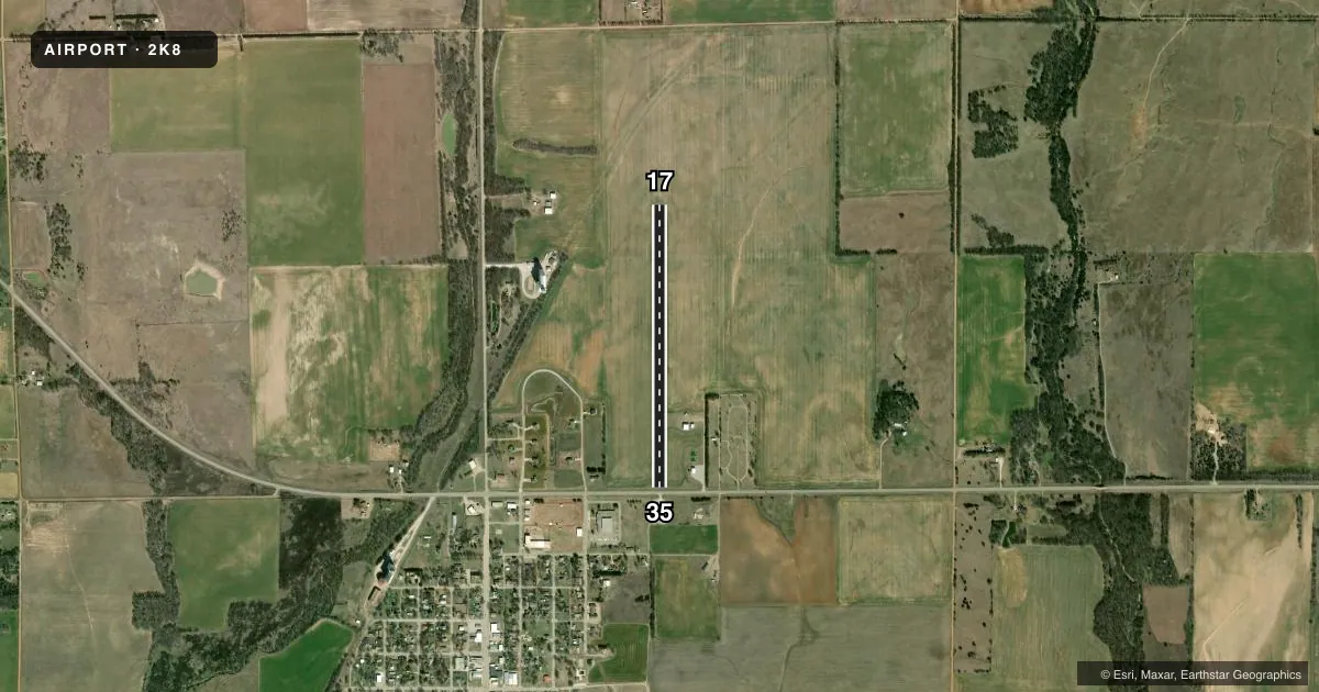
Runways & pattern
Full pagePattern entry · RWY 17
LEFT TRAFFICRunway end performance
| End | TORA | TODA | ASDA | LDA | VGSI | Approach lights | Obstruction |
|---|---|---|---|---|---|---|---|
| 35 | — | — | — | — | — | — | 30', pole, 10' from thr, 80' R of cntrln, slope 0 |
Declared distances in feet. TORA = takeoff run available, TODA = takeoff distance, ASDA = accelerate-stop, LDA = landing distance.
Airport sketch
Runways drawn to scale from FAA survey coordinates, rendered over satellite imagery. Not for navigation.
Approaches & charts
Services on the field
Fuel grades, oxygen, maintenance, ramp storage and lighting — as declared to the FAA by the airport operator.
Fuel & services
- Fuel
- Not available
Ramp & ground
- Transient storage
- Tie-down
- Landing fee
- No fee published
- Wind indicator
- Yes
- Segmented circle
- No
Fuel & FBOs
Cheapest 100LL and Jet A on the field and nearby. Always confirm with the FBO before taxi.
Airport notes
Surface conditions, obstructions, local procedures, lighting outages and other notes published with each FAA cycle.
General notes
- FOR CD CTC WICHITA APCH AT 316-350-1520.
Approach & departure obstructions
- 17CONTROLLING OBSTN EXCEEDS A 45 DEG SLP.
Other notes
- PRVDD APCH TO EACH RWY IS MAINTD FOR A MIN 20:1 GLIDE SLOPE AND THE TRSNL SFC BE MAINTD FOR A 7:1 SLOPE.
VFR map & nearby airports
VFR sectional. Tap any ICAO chip to open that airport.
Key facts · 2K8
Answer card- ICAO
- 2K8
- Name
- ARGONIA MUNI
- Location
- ARGONIA, KANSAS
- Elevation
- 1,279 ft MSL
- Traffic pattern altitude
- 2,279 ft MSL (1,000 AGL)
- Control tower
- Non-towered (use CTAF)
- Total runways
- 1
- Longest runway
- 17/35 · 3,200 ft
- Published ILS approaches
- 0
- Published frequencies
- 1
- Magnetic variation
- 7°
- Current flight rules
- VFR
- Current wind
- 190° at 12 kt
- Favored runway now
- RWY 17
Argonia Muni sits in Argonia, Kansas at 1,279 ft MSL. It has one runway. Runway 17/35 is 3,200 ft of turf, so plan for soft-field technique and check the surface before you go. The field is non-towered. CTAF is 122.9. No ILS approaches are published here.
Pattern altitude is not published. Use the standard 1,000 ft AGL pattern unless the current FAA Chart Supplement or local traffic calls for something different. That puts the pattern at about 2,279 ft MSL based on the field elevation, but verify before flight. Published remarks note a controlling obstruction near runway 17 that exceeds a 45 degree slope. That is a good reason to brief your departure and arrival paths carefully, especially if you are operating a heavier airplane or flying a short-field profile.
There are no on-field FBOs listed. FBO options vary. Contact the airport operator directly before arrival, or call the field on CTAF/UNICOM for current FBO availability. For clearance delivery, Wichita Approach is listed at 316-350-1520. If you need current noise, curfew, or local operating details, check the current FAA Chart Supplement before you fly in.