METAR & TAF 8K2
8K2 does not publish a METAR.
Showing the nearest reporting station: KANY (ANTHONY MUNI) · 7.3 NM away. Conditions at 8K2 may differ.
METAR · KANY
Observed 13:15Z
KANY 271315Z AUTO 18008KT 10SM CLR 27/19 A2988 RMK AO2
- Wind
- 180° @ 8 kt
- Visibility
- 10 SM
- Temp / Dew
- 27°C / 19°C
- Altimeter
- 29.88 inHg
- Clouds
- CLR
- Density alt
- 3,259 ft
- Ceiling
- Unlimited
- Rules
- VFR
Airport info & contacts
Manager on record, flight service, ARTCC, attendance schedule and pattern altitude — published by the FAA and refreshed every 28 days.
Location
- From city
- 1 NM SW
- VFR sectional
- WICHITA
- ARTCC
- ZKC · KANSAS CITY
- NOTAM facility
- ICT (NOTAM-D)
Airport manager
- Name
- KAREN BEFORT
- Phone
- 620-896-2511
- Address
- 201 WEST MAIN, HARPER KS 67058
Flight service · Hours
- FSS ICT
- WICHITA1-800-WX-BRIEF
- Attendance
- Unattended
Frequencies
Tap any row to copy the frequency to your clipboard.
Runways & pattern
Full pagePattern entry · RWY 17
LEFT TRAFFIC| Runway | Heading (°M) | Length | Surface | Traffic |
|---|---|---|---|---|
| 17/35Favored | 168° / 348° | 3,268 ft | ASPH | Standard L |
| 12/30 | 127° / 307° | 2,138 ft | TURF | Standard L |
Runway end performance
| End | TORA | TODA | ASDA | LDA | VGSI | Approach lights | Obstruction |
|---|---|---|---|---|---|---|---|
| 17 | — | — | — | — | PAPI 2-box left(3.25°) | — | 44', tree, 440' from thr, 156' R of cntrln, slope 5 |
| 35 | — | — | — | — | PAPI 2-box left(3.25°) | — | — |
| 12 | — | — | — | — | — | — | 49', pline, 644' from thr, 207' R of cntrln, slope 13 |
| 30 | — | — | — | — | — | — | 42', pline, 788' from thr, 205' R of cntrln, slope 18 |
Declared distances in feet. TORA = takeoff run available, TODA = takeoff distance, ASDA = accelerate-stop, LDA = landing distance.
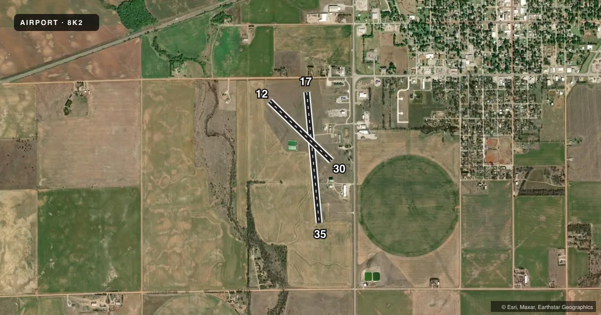
Airport sketch
Runways drawn to scale from FAA survey coordinates, rendered over satellite imagery. Not for navigation.
Approaches & charts
Services on the field
Fuel grades, oxygen, maintenance, ramp storage and lighting — as declared to the FAA by the airport operator.
Fuel & services
- Fuel
- 100LL
- Oxygen (bottled)
- Not available
- Oxygen (bulk)
- Not available
- Other services
- AGRI
Ramp & ground
- Transient storage
- Tie-down
- Landing fee
- No fee published
- Customs
- Not available
- Lighting schedule
- SEE RMK
- Wind indicator
- Lighted
- Segmented circle
- No
Fuel & FBOs
Cheapest 100LL and Jet A on the field and nearby. Always confirm with the FBO before taxi.
Airport notes
Surface conditions, obstructions, local procedures, lighting outages and other notes published with each FAA cycle.
General notes
- RWY 12, 3 FT DITCH 50 FM N END.
- FOR CD CTC WICHITA APCH AT 316-350-1520.
Lighting notes
- ACTVT PAPI RWY 17 & 35, HIRL RWY 17/35 - CTAF.
Fuel notes
- 100LLFUEL SELF SERVE.
Approach & departure obstructions
- 12MKD WITH METAL ORANGE CONES.
- 17RWY 17 PAPI UNUSBL BYD 3 DEGS L OF CNTRLN.
Other notes
- THIS AIRPORT HAS BEEN SURVEYED BY THE NATIONAL GEODETIC SURVEY.
- MAINT APCHS FOR A 20:1 GLIDE SLOPE AND TRSNL SFC FOR A 7:1 SLOPE.
- AUTOMATED UNICOM; 3 CLICKS ADZY & WX, 4 CLICKS RADIO CHECK. ADZY ALSO AVBL BY CALLING 617-262-3825.
- MANAGERDEPUTY CITY CLERK/AMGR.
VFR map & nearby airports
VFR sectional. Tap any ICAO chip to open that airport.
Key facts · 8K2
Answer card- ICAO
- 8K2
- Name
- HARPER MUNI
- Location
- HARPER, KANSAS
- Elevation
- 1,427 ft MSL
- Traffic pattern altitude
- 2,427 ft MSL (1,000 AGL)
- Control tower
- Non-towered (use CTAF)
- Total runways
- 2
- Longest runway
- 17/35 · 3,268 ft
- Published ILS approaches
- 0
- Published frequencies
- 3
- Magnetic variation
- 7°
- Current flight rules
- VFR
- Current wind
- 180° at 8 kt
- Favored runway now
- RWY 17
HARPER MUNI sits in Harper, Kansas. The field elevation is 1,427 ft MSL. It has two runways. The longest is runway 17/35 at 3,268 ft. This is a non-towered airport, so plan to self-announce on CTAF 122.9. The CTAF is an automated UNICOM. Three clicks activate advisory and weather. Four clicks perform a radio check. Advisory is also available by phone if needed.
No ILS approaches are published here. For IFR work, Wichita Approach handles clearance delivery. The published pattern altitude is not listed, so use standard 1,000 ft AGL for light piston operations unless the current Chart Supplement says otherwise. Runway 17 and runway 35 have PAPI. They also have high intensity runway lights. The PAPI on runway 17 is unusable beyond 3 degrees left of centerline. That matters on final if you are not lined up well.
Harper Municipal Airport is on the field and carries self-serve 100LL. Runway 12 is marked with metal orange cones. There is also a 3-foot ditch 50 feet from the north end of runway 12, so pay close attention if you use that end. The airport sits in open Kansas terrain, so winds can make the turf runway and the shorter runway 12/30 more of a factor than the numbers suggest.