METAR & TAF KBKN
Current METAR
Observed 16:15Z
KBKN 271615Z AUTO 20010KT 170V230 9SM CLR 36/19 A2986 RMK AO2
- Wind
- 200° @ 10 kt
- Visibility
- 9 SM
- Temp / Dew
- 36°C / 19°C
- Altimeter
- 29.86 inHg
- Clouds
- CLR
- Density alt
- 3,872 ft
- Ceiling
- Unlimited
- Rules
- VFR
Airport info & contacts
Manager on record, flight service, ARTCC, attendance schedule and pattern altitude — published by the FAA and refreshed every 28 days.
Location
- From city
- 5 NM SW
- VFR sectional
- WICHITA
- ARTCC
- ZKC · KANSAS CITY
- NOTAM facility
- MLC (NOTAM-D)
Airport manager
- Name
- DENNIS PEARCE
- Phone
- 580-363-4242
- Address
- 16705 W. HUBBARD ROAD, BLACKWELL OK 74631
Flight service · Hours
- FSS MLC
- MC ALESTER1-800-WX-BRIEF
- Attendance
- IRREG
Frequencies
Tap any row to copy the frequency to your clipboard.
Runways & pattern
Full pagePattern entry · RWY 17
LEFT TRAFFICRunway end performance
| End | TORA | TODA | ASDA | LDA | VGSI | Approach lights | Obstruction |
|---|---|---|---|---|---|---|---|
| 17 | — | — | — | — | PAPI 2-box left(3°) | — | — |
| 35 | — | — | — | — | PAPI 2-box left(3°) | — | — |
Declared distances in feet. TORA = takeoff run available, TODA = takeoff distance, ASDA = accelerate-stop, LDA = landing distance.
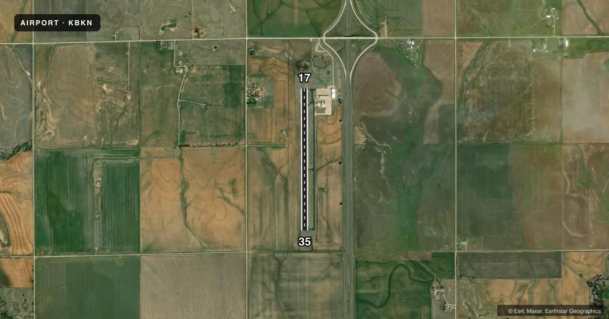
Airport sketch
Runways drawn to scale from FAA survey coordinates, rendered over satellite imagery. Not for navigation.
Approaches & charts
Services on the field
Fuel grades, oxygen, maintenance, ramp storage and lighting — as declared to the FAA by the airport operator.
Fuel & services
- Fuel
- 100LL
- Oxygen (bottled)
- Not available
- Oxygen (bulk)
- Not available
- Airframe repair
- Not available
- Power plant repair
- Not available
- Other services
- AGRI
Ramp & ground
- Transient storage
- Tie-down
- Hangar
- Customs
- Not available
- Lighting schedule
- SEE RMK
- Beacon schedule
- SS-SR
- Beacon
- White / Green (civil land)(WG)
- Wind indicator
- Lighted
- Segmented circle
- Yes
Fuel & FBOs
Cheapest 100LL and Jet A on the field and nearby. Always confirm with the FBO before taxi.
Airport notes
Surface conditions, obstructions, local procedures, lighting outages and other notes published with each FAA cycle.
General notes
- FOR CD CTC KANSAS CITY ARTCC AT 913-254-8508.
Lighting notes
- ACTVT & INCR INTST MIRL RWY 17/35 - CTAF. PAPI RWY 17 & 35 ON CONSLY.
Fuel notes
- 100LLFUEL AVBL 24 HRS THRU AUTOMATED CREDIT CARD SYSTEM.
Other notes
- THIS AIRPORT HAS BEEN SURVEYED BY THE NATIONAL GEODETIC SURVEY.
- ARPT LCTD 5 MILES SW BLACKWELL; 5 MILES NW TONKAWA.
VFR map & nearby airports
VFR sectional. Tap any ICAO chip to open that airport.
Key facts · KBKN
Answer card- ICAO
- KBKN
- Name
- BLACKWELL-TONKAWA MUNI
- Location
- BLACKWELL, OKLAHOMA
- Elevation
- 1,030 ft MSL
- Traffic pattern altitude
- 2,030 ft MSL (1,000 AGL)
- Control tower
- Non-towered (use CTAF)
- Total runways
- 1
- Longest runway
- 17/35 · 3,501 ft
- Published ILS approaches
- 0
- Published frequencies
- 2
- Magnetic variation
- 6°
- Current flight rules
- VFR
- Current wind
- 200° at 10 kt
- Favored runway now
- RWY 17
Blackwell-Tonkawa Muni (KBKN) sits in Blackwell, Oklahoma. The field elevation is 1,030 ft MSL. It has one runway, 17/35, which is 3,501 ft long and asphalt. This is an uncontrolled airport. CTAF and UNICOM are both 122.8. No ILS approaches are published here.
The pattern altitude is not published. Use 1,000 ft AGL for light piston operations unless the current Chart Supplement says otherwise. The airport is 5 miles southwest of Blackwell and 5 miles northwest of Tonkawa. Magnetic variation is 6°. The runway lighting can be activated and the intensity increased on CTAF. PAPI on both runway ends runs continuously. Fuel is available 24 hours through an automated credit card system. The on-field airport FBO is Blackwell-Tonkawa Municipal Airport. It carries AVGAS 100LL. For clearance delivery, contact Kansas City ARTCC at 913-254-8508. A first-time pilot should plan for a simple non-towered arrival with standard self-announce discipline. Check the current Chart Supplement for any local procedures before you go.