METAR & TAF F22
F22 does not publish a METAR.
Showing the nearest reporting station: KSWO (STILLWATER RGNL) · 16.3 NM away. Conditions at F22 may differ.
METAR · KSWO
Observed 12:53Z
KSWO 271253Z 18006KT 10SM CLR 27/18 A2990 RMK AO2 SLP109 T02720183
- Wind
- 180° @ 6 kt
- Visibility
- 10 SM
- Temp / Dew
- 27°C / 18°C
- Altimeter
- 29.90 inHg
- Clouds
- CLR
- Density alt
- 2,708 ft
- Ceiling
- Unlimited
- Rules
- VFR
Airport info & contacts
Manager on record, flight service, ARTCC, attendance schedule and pattern altitude — published by the FAA and refreshed every 28 days.
Location
- From city
- 5 NM N
- VFR sectional
- WICHITA
- ARTCC
- ZKC · KANSAS CITY
- NOTAM facility
- MLC (NOTAM-D)
Airport manager
- Name
- TERENCE HULET
- Phone
- 580-336-4001
- Address
- 15500 CR 110, PERRY OK 73077
Flight service · Hours
- FSS MLC
- MC ALESTER1-800-WX-BRIEF
- Attendance
- 0800 - 1700
Frequencies
Tap any row to copy the frequency to your clipboard.
Runways & pattern
Full pagePattern entry · RWY 17
LEFT TRAFFICRunway end performance
| End | TORA | TODA | ASDA | LDA | VGSI | Approach lights | Obstruction |
|---|---|---|---|---|---|---|---|
| 17 | — | — | — | — | PAPI 2-box left(3°) | — | — |
| 35 | — | — | — | — | PAPI 2-box left(3°) | — | 20', road, 670' from thr, 0' R of cntrln, slope 23 |
Declared distances in feet. TORA = takeoff run available, TODA = takeoff distance, ASDA = accelerate-stop, LDA = landing distance.
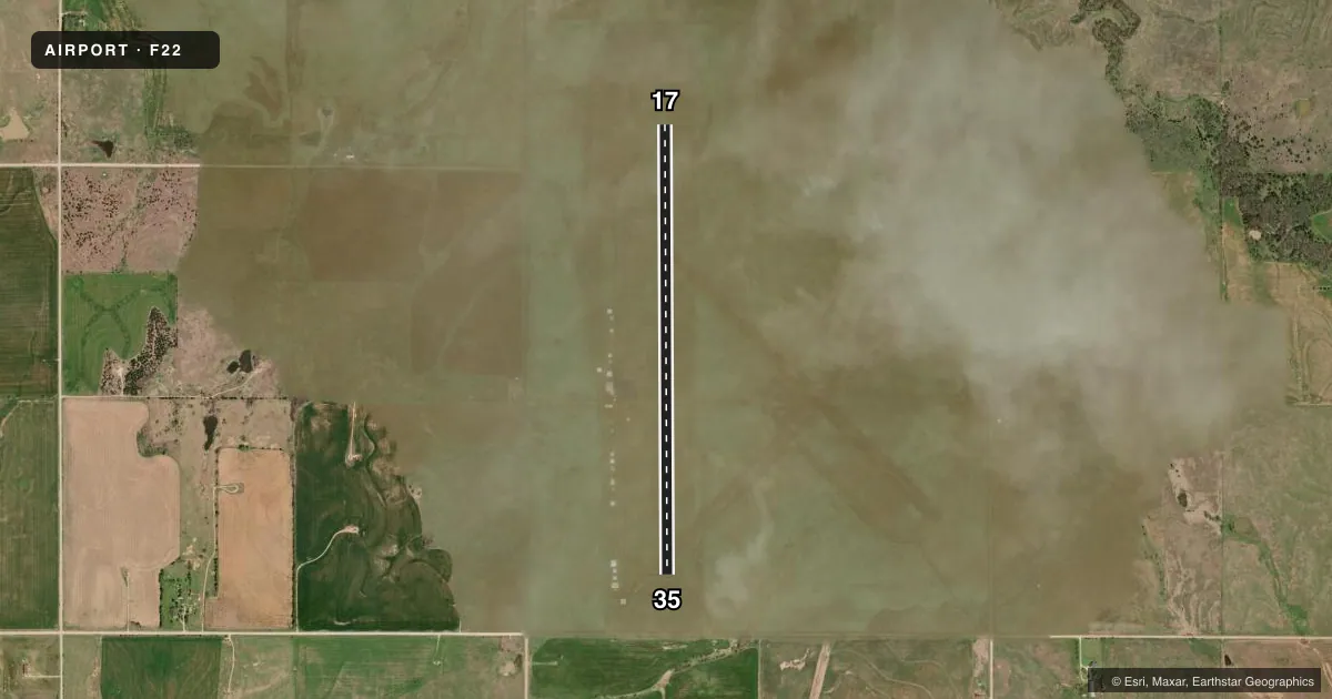
Airport sketch
Runways drawn to scale from FAA survey coordinates, rendered over satellite imagery. Not for navigation.
Approaches & charts
Services on the field
Fuel grades, oxygen, maintenance, ramp storage and lighting — as declared to the FAA by the airport operator.
Fuel & services
- Fuel
- 100LLA+
- Oxygen (bottled)
- Not available
- Oxygen (bulk)
- Not available
- Airframe repair
- Minor
- Power plant repair
- Minor
- Other services
- AGRI
Ramp & ground
- Transient storage
- Tie-down
- Hangar
- Landing fee
- No fee published
- Customs
- Not available
- Lighting schedule
- SEE RMK
- Beacon schedule
- SS-SR
- Beacon
- White / Green (civil land)(WG)
- Wind indicator
- Lighted
- Segmented circle
- Yes
Fuel & FBOs
Cheapest 100LL and Jet A on the field and nearby. Always confirm with the FBO before taxi.
Airport notes
Surface conditions, obstructions, local procedures, lighting outages and other notes published with each FAA cycle.
General notes
- ULTRALIGHT ACTIVITY ON & INVOF ARPT.
- FOR CD CTC KANSAS CITY ARTCC AT 913-254-8508.
Lighting notes
- ACTVT MIRL RY 17/35 AND REIL RWY 17 & RWY 35 - CTAF.
Other notes
- THIS AIRPORT HAS BEEN SURVEYED BY THE NATIONAL GEODETIC SURVEY.
- ESTAB PRIOR TO 1959.
- 1AIRPORT UNATTENDED CHRISTMAS DAY.
VFR map & nearby airports
VFR sectional. Tap any ICAO chip to open that airport.
Key facts · F22
Answer card- ICAO
- F22
- Name
- PERRY MUNI
- Location
- PERRY, OKLAHOMA
- Elevation
- 1,002.5 ft MSL
- Traffic pattern altitude
- 2,002.5 ft MSL (1,000 AGL)
- Control tower
- Non-towered (use CTAF)
- Total runways
- 1
- Longest runway
- 17/35 · 5,103 ft
- Published ILS approaches
- 0
- Published frequencies
- 2
- Magnetic variation
- 6°
- Current flight rules
- VFR
- Current wind
- 180° at 6 kt
- Favored runway now
- RWY 17
Perry Muni sits in Perry, Oklahoma. The field elevation is 1,002.5 ft MSL. It has one runway, 17/35, which is 5,103 ft of asphalt. There is no control tower. CTAF and UNICOM are both 122.8. No ILS approaches are published here.
The pattern altitude is not published. Use the standard 1,000 ft AGL for light piston operations unless the current Chart Supplement says otherwise. The airport carries medium intensity runway lights on 17/35. Runway end identifier lights are installed on both ends. Ultralight activity occurs on and near the airport, so keep a sharp scan in the pattern and on departure.
Perry Municipal Airport is the on-field FBO. It carries 100LL and Jet A. Call (580) 336-4001 for current service details before arrival. For clearance delivery, contact Kansas City Center at 913-254-8508. This field was established prior to 1959. It has also been surveyed by the National Geodetic Survey. First-time arrivals should plan for an unattended non-towered airport with mixed traffic. Verify any current airport notes in the FAA Chart Supplement before you go.