METAR & TAF 1OK
1OK does not publish a METAR.
Showing the nearest reporting station: KWDG (ENID WOODRING RGNL) · 5.9 NM away. Conditions at 1OK may differ.
METAR · KWDG
Observed 05:35Z
KWDG 270535Z AUTO 17007KT 10SM CLR 27/21 A2988 RMK AO2
- Wind
- 170° @ 7 kt
- Visibility
- 10 SM
- Temp / Dew
- 27°C / 21°C
- Altimeter
- 29.88 inHg
- Clouds
- CLR
- Density alt
- 2,940 ft
- Ceiling
- Unlimited
- Rules
- VFR
Airport info & contacts
Manager on record, flight service, ARTCC, attendance schedule and pattern altitude — published by the FAA and refreshed every 28 days.
Location
- From city
- 2 NM NE
- VFR sectional
- WICHITA
- ARTCC
- ZKC · KANSAS CITY
- NOTAM facility
- MLC (NOTAM-D)
Airport manager
- Name
- KENNETH R. HOLLRAH
- Phone
- 580-242-6627
- Address
- PO BOX 2403, UNIVERSITY STN, ENID OK 73702-2403
Flight service · Hours
- FSS MLC
- MC ALESTER1-800-WX-BRIEF
- Attendance
- Unattended
Frequencies
Tap any row to copy the frequency to your clipboard.
Runways & pattern
Full pagePattern entry · RWY 17
LEFT TRAFFICRunway end performance
| End | TORA | TODA | ASDA | LDA | VGSI | Approach lights | Obstruction |
|---|---|---|---|---|---|---|---|
| 35 | — | — | — | — | — | — | 16', road, 67' from thr, 0' R of cntrln, slope 4 |
Declared distances in feet. TORA = takeoff run available, TODA = takeoff distance, ASDA = accelerate-stop, LDA = landing distance.
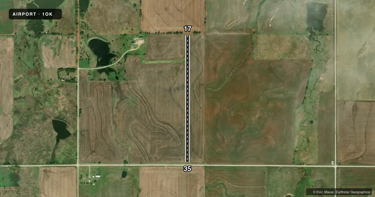
Airport sketch
Runways drawn to scale from FAA survey coordinates, rendered over satellite imagery. Not for navigation.
Approaches & charts
Services on the field
Fuel grades, oxygen, maintenance, ramp storage and lighting — as declared to the FAA by the airport operator.
Fuel & services
- Fuel
- Not available
- Contract fuel
- Not available
Ramp & ground
- Transient storage
- Not published
- Landing fee
- Yes
- Wind indicator
- Yes
- Segmented circle
- No
Fuel & FBOs
Cheapest 100LL and Jet A on the field and nearby. Always confirm with the FBO before taxi.
Airport notes
Surface conditions, obstructions, local procedures, lighting outages and other notes published with each FAA cycle.
General notes
- FOR CD CTC VANCE APCH AT580-213-6765. WHEN VANCE APCH IS CLSD, CTC KANSAS CITY ARTCC AT 913-254-8508.
- WILDLIFE ON & INVOF ARPT.
- 4 FT SEASONAL CROPS BOTH APCH ENDS RWY 17/35.
Approach & departure obstructions
- 17RWY END & MIDPT MKRS.
- 35RWY END & MIDPT MKRS.
- 17DITCH.
Other notes
- IT IS RCMDD THE ARPT INSTL A SEGMENTED MKR SYS IAW AC 150/5340-5, SEGMENTED CRC ARPT MKR SYS, TO DESIGNATE THE DRCTN OF THE ARPT TRFC PAT. THE ARPT MAY CHG THE VFR TFC PAT VIA NOTAM TO TAKE EFCT BFR THE NXT FAA PUB CYCLE.
VFR map & nearby airports
VFR sectional. Tap any ICAO chip to open that airport.
Key facts · 1OK
Answer card- ICAO
- 1OK
- Name
- FAIRMONT FLD
- Location
- FAIRMONT, OKLAHOMA
- Elevation
- 1,170 ft MSL
- Traffic pattern altitude
- 2,170 ft MSL (1,000 AGL)
- Control tower
- Non-towered (use CTAF)
- Total runways
- 1
- Longest runway
- 17/35 · 2,540 ft
- Published ILS approaches
- 0
- Published frequencies
- 1
- Magnetic variation
- –
- Current flight rules
- VFR
- Current wind
- 170° at 7 kt
- Favored runway now
- RWY 17
Fairmont Fld is in Fairmont, Oklahoma. The field elevation is 1,170 ft MSL. It has one runway, 17/35, which is 2,540 ft long and turf. No control tower is published. CTAF is 122.9. No ILS approaches are published here.
Pattern altitude is not published. Use the standard 1,000 ft AGL pattern unless the current Chart Supplement or a NOTAM says otherwise. The published remarks matter here. There is a ditch at the end of runway 17. Four-foot seasonal crops are present at both approach ends of runway 17/35. Wildlife is also present on and near the airport. Runway end and midpoint markers are installed on both ends, which helps with orientation on the turf strip.
There are no on-field FBOs listed. Plan on self-briefing the field and calling ahead if you need local support. For clearance delivery, contact Vance Approach at 580-213-6765. When Vance Approach is closed, contact Kansas City ARTCC at 913-254-8508. First-time pilots should pay close attention to the crop height, wildlife and the ditch near runway 17. This is a small non-towered turf airport. A careful traffic scan and a conservative short-field plan make sense.