METAR & TAF 2K1
2K1 does not publish a METAR.
Showing the nearest reporting station: KWDG (ENID WOODRING RGNL) · 17.2 NM away. Conditions at 2K1 may differ.
METAR · KWDG
Observed 14:50Z
KWDG 271450Z 21009KT 10SM CLR 32/20 A2989
- Wind
- 210° @ 9 kt
- Visibility
- 10 SM
- Temp / Dew
- 32°C / 20°C
- Altimeter
- 29.89 inHg
- Clouds
- CLR
- Density alt
- 3,393 ft
- Ceiling
- Unlimited
- Rules
- VFR
Airport info & contacts
Manager on record, flight service, ARTCC, attendance schedule and pattern altitude — published by the FAA and refreshed every 28 days.
Location
- From city
- 0 NM SW
- VFR sectional
- WICHITA
- ARTCC
- ZKC · KANSAS CITY
- NOTAM facility
- MLC (NOTAM-D)
Airport manager
- Name
- ART CURL
- Phone
- 580-532-4915
- Address
- CITY HALL, PO BOX 6, POND CREEK OK 73766
Flight service · Hours
- FSS MLC
- MC ALESTER1-800-WX-BRIEF
- Attendance
- Unattended
Frequencies
Tap any row to copy the frequency to your clipboard.
Runways & pattern
Full pagePattern entry · RWY 17
LEFT TRAFFIC| Runway | Heading (°M) | Length | Surface | Traffic |
|---|---|---|---|---|
| 17/35Favored | 173° / 353° | 2,320 ft | TURF | Standard L |
| 15/33 | 150° / 330° | 1,220 ft | ASPH | Standard L |
Runway end performance
| End | TORA | TODA | ASDA | LDA | VGSI | Approach lights | Obstruction |
|---|---|---|---|---|---|---|---|
| 17 | — | — | — | — | — | — | 35', pole, 100' from thr, 0' R of cntrln, slope 2 |
| 15 | — | — | — | — | — | — | 25', trees, 226' from thr, 115' R of cntrln, slope 1 |
Declared distances in feet. TORA = takeoff run available, TODA = takeoff distance, ASDA = accelerate-stop, LDA = landing distance.
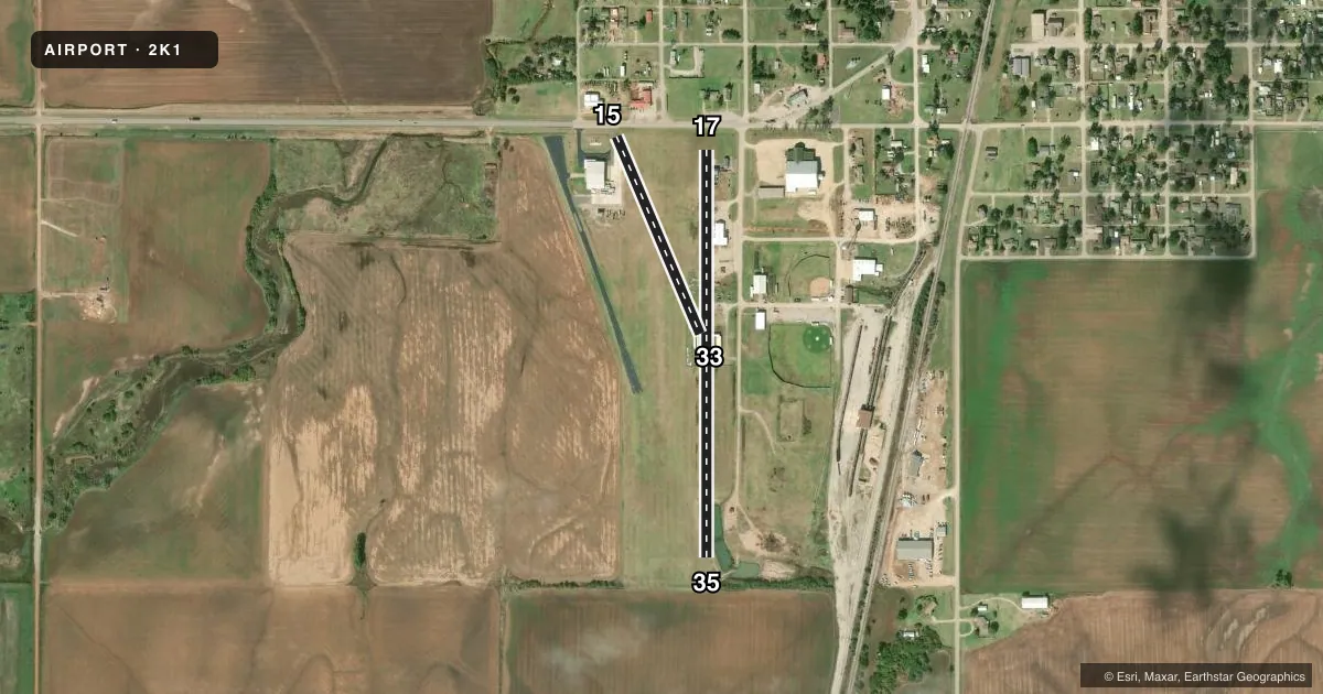
Airport sketch
Runways drawn to scale from FAA survey coordinates, rendered over satellite imagery. Not for navigation.
Approaches & charts
Services on the field
Fuel grades, oxygen, maintenance, ramp storage and lighting — as declared to the FAA by the airport operator.
Fuel & services
- Fuel
- Not available
- Oxygen (bottled)
- Not available
- Oxygen (bulk)
- Not available
- Airframe repair
- Not available
- Power plant repair
- Not available
- Other services
- AGRI
Ramp & ground
- Transient storage
- Not published
- Landing fee
- No fee published
- Customs
- Not available
- Wind indicator
- No
- Segmented circle
- No
Fuel & FBOs
Cheapest 100LL and Jet A on the field and nearby. Always confirm with the FBO before taxi.
Airport notes
Surface conditions, obstructions, local procedures, lighting outages and other notes published with each FAA cycle.
General notes
- RWY 15/33 PVT MAINTAINED.
- FOR CD CTC VANCE APCH AT 580-213-6765. WHEN VANCE APCH IS CLSD, CTC KANSAS CITY ARTCC AT 913-254-8508.
Runway surface & condition
- 17/35FULL WIDTH OF RY NOT MAINTAINED; USE MIDDLE OF RY SFC.
Approach & departure obstructions
- 15+15' ROAD 60' FM THRLD END.
Other notes
- MANAGERMAINTENANCE SUPERVISOR.
- MANAGEROR CONTACT POLICE DEPARTMENT 580-532-5050.
VFR map & nearby airports
VFR sectional. Tap any ICAO chip to open that airport.
Key facts · 2K1
Answer card- ICAO
- 2K1
- Name
- POND CREEK MUNI
- Location
- POND CREEK, OKLAHOMA
- Elevation
- 1,061 ft MSL
- Traffic pattern altitude
- 2,061 ft MSL (1,000 AGL)
- Control tower
- Non-towered (use CTAF)
- Total runways
- 2
- Longest runway
- 17/35 · 2,320 ft
- Published ILS approaches
- 0
- Published frequencies
- 1
- Magnetic variation
- 7°
- Current flight rules
- VFR
- Current wind
- 210° at 9 kt
- Favored runway now
- RWY 17
Pond Creek Muni sits in Pond Creek, Oklahoma. Field elevation is 1,061 ft MSL. It has two runways. The longest is runway 17/35 at 2,320 ft on turf. Runway 15/33 is 1,220 ft on asphalt. There is no control tower. CTAF is 122.9.
No ILS approaches are published here. Pattern altitude is not published, so use the standard 1,000 ft AGL for light piston traffic unless the current FAA Chart Supplement says otherwise. That puts the common pattern reference at 2,061 ft MSL based on the listed field elevation. The airport is not towered, so keep your radio work tight and verify traffic before joining.
A few published remarks matter here. Runway 17/35 is not maintained full width, so plan to use the middle of the surface. Runway 15 has a road 60 ft from the threshold end. Runway 15/33 is privately maintained. For clearance delivery, contact Vance Approach at 580-213-6765. When Vance Approach is closed, contact Kansas City ARTCC at 913-254-8508. No on-field FBOs are listed, so verify fuel and services with the airport operator or the field directly before you go.