METAR & TAF 4O7
4O7 does not publish a METAR.
Showing the nearest reporting station: KWDG (ENID WOODRING RGNL) · 18.8 NM away. Conditions at 4O7 may differ.
METAR · KWDG
Observed 15:50Z
KWDG 271550Z 22009KT 10SM CLR 34/20 A2989
- Wind
- 220° @ 9 kt
- Visibility
- 10 SM
- Temp / Dew
- 34°C / 20°C
- Altimeter
- 29.89 inHg
- Clouds
- CLR
- Density alt
- 3,966 ft
- Ceiling
- Unlimited
- Rules
- VFR
Airport info & contacts
Manager on record, flight service, ARTCC, attendance schedule and pattern altitude — published by the FAA and refreshed every 28 days.
Location
- From city
- 1 NM S
- VFR sectional
- WICHITA
- ARTCC
- ZKC · KANSAS CITY
- NOTAM facility
- MLC (NOTAM-D)
Airport manager
- Name
- RONNIE L DECKER
- Phone
- 580-554-2814
- Address
- RT 2 BOX 97, MENO OK 73760
Flight service · Hours
- FSS MLC
- MC ALESTER1-800-WX-BRIEF
- Attendance
- 0700-1900
Frequencies
Tap any row to copy the frequency to your clipboard.
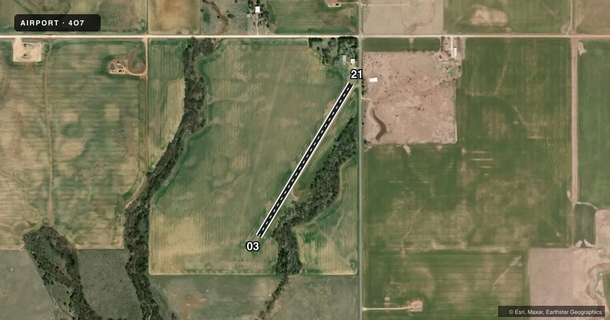
Runways & pattern
Full pagePattern entry · RWY 21
LEFT TRAFFICRunway end performance
| End | TORA | TODA | ASDA | LDA | VGSI | Approach lights | Obstruction |
|---|---|---|---|---|---|---|---|
| 21 | — | — | — | — | — | — | 16', road, 110' from thr, 0' R of cntrln, slope 7 |
Declared distances in feet. TORA = takeoff run available, TODA = takeoff distance, ASDA = accelerate-stop, LDA = landing distance.
Airport sketch
Runways drawn to scale from FAA survey coordinates, rendered over satellite imagery. Not for navigation.
Approaches & charts
Services on the field
Fuel grades, oxygen, maintenance, ramp storage and lighting — as declared to the FAA by the airport operator.
Fuel & services
- Fuel
- Not available
- Oxygen (bottled)
- Not available
- Oxygen (bulk)
- Not available
- Airframe repair
- Major
- Power plant repair
- Major
Ramp & ground
- Transient storage
- Tie-down
- Landing fee
- No fee published
- Wind indicator
- Yes
- Segmented circle
- No
Fuel & FBOs
Cheapest 100LL and Jet A on the field and nearby. Always confirm with the FBO before taxi.
Airport notes
Surface conditions, obstructions, local procedures, lighting outages and other notes published with each FAA cycle.
General notes
- 35 RWY MKD POWER LINE 480 FT FM RWY 21 END.
- FOR CD CTC VANCE APCH AT 580-213-6765. WHEN VANCE APCH IS CLSD, CTC KANSAS CITY ARTCC AT 913-254-8508.
VFR map & nearby airports
VFR sectional. Tap any ICAO chip to open that airport.
Key facts · 4O7
Answer card- ICAO
- 4O7
- Name
- DECKER FLD
- Location
- MENO, OKLAHOMA
- Elevation
- 1,330 ft MSL
- Traffic pattern altitude
- 2,330 ft MSL (1,000 AGL)
- Control tower
- Non-towered (use CTAF)
- Total runways
- 1
- Longest runway
- 03/21 · 2,215 ft
- Published ILS approaches
- 0
- Published frequencies
- 1
- Magnetic variation
- 7°
- Current flight rules
- VFR
- Current wind
- 220° at 9 kt
- Favored runway now
- RWY 21
Decker Fld sits near Meno, Oklahoma. The field elevation is 1,330 ft MSL. It has one runway. Runway 03/21 is 2,215 ft of turf, so plan for a short-field grass strip with the usual surface and braking limits that come with turf. No control tower is listed. CTAF is 122.9.
No ILS approaches are published here. The pattern altitude is not published in the facts, so use the current Chart Supplement before you go. The airport is not towered, so expect self-announce traffic and keep a sharp scan on the CTAF. Published remarks say to contact Vance Approach for clearance delivery. When Vance Approach is closed, contact Kansas City ARTCC. The remarks also note a power line marked near the Runway 21 end. That is worth respecting on departure and landing.
No on-field FBOs are listed in the facts. If you need fuel or other services, call the airport operator or the field directly before arrival. For a first-time pilot, the main things here are the turf surface, the short runway and the obstacle note near Runway 21. Check the current Chart Supplement for any other operational notes before flying in.