METAR & TAF O53
O53 does not publish a METAR.
Showing the nearest reporting station: KBKN (BLACKWELL-TONKAWA MUNI) · 19.4 NM away. Conditions at O53 may differ.
METAR · KBKN
Observed 14:55Z
KBKN 271455Z AUTO 19013KT 9SM CLR 34/19 A2987 RMK AO2
- Wind
- 190° @ 13 kt
- Visibility
- 9 SM
- Temp / Dew
- 34°C / 19°C
- Altimeter
- 29.87 inHg
- Clouds
- CLR
- Density alt
- 3,696 ft
- Ceiling
- Unlimited
- Rules
- VFR
Airport info & contacts
Manager on record, flight service, ARTCC, attendance schedule and pattern altitude — published by the FAA and refreshed every 28 days.
Location
- From city
- 1 NM SW
- VFR sectional
- WICHITA
- ARTCC
- ZKC · KANSAS CITY
- NOTAM facility
- MLC (NOTAM-D)
Airport manager
- Name
- STEVEN BIRKELBACH
- Phone
- 580-395-2875
- Address
- 615 N. FRONT ST., PO BOX 123, MEDFORD OK 73759
Flight service · Hours
- FSS MLC
- MC ALESTER1-800-WX-BRIEF
- Attendance
- IREG
Frequencies
Tap any row to copy the frequency to your clipboard.
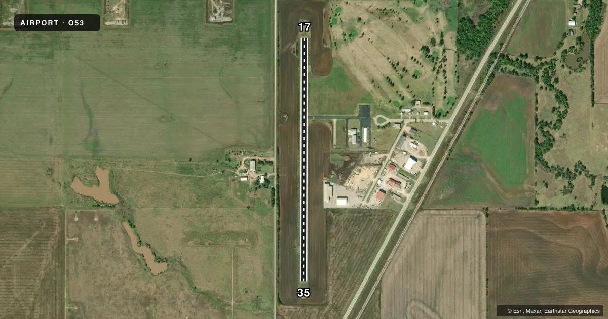
Runways & pattern
Full pagePattern entry · RWY 17
LEFT TRAFFICRunway end performance
| End | TORA | TODA | ASDA | LDA | VGSI | Approach lights | Obstruction |
|---|---|---|---|---|---|---|---|
| 17 | — | — | — | — | PAPI 2-box left(3.51°) | — | — |
| 35 | — | — | — | — | PAPI 2-box left(3.51°) | — | — |
Declared distances in feet. TORA = takeoff run available, TODA = takeoff distance, ASDA = accelerate-stop, LDA = landing distance.
Airport sketch
Runways drawn to scale from FAA survey coordinates, rendered over satellite imagery. Not for navigation.
Approaches & charts
Services on the field
Fuel grades, oxygen, maintenance, ramp storage and lighting — as declared to the FAA by the airport operator.
Fuel & services
- Fuel
- Not available
- Oxygen (bottled)
- Not available
- Oxygen (bulk)
- Not available
- Airframe repair
- Not available
- Power plant repair
- Not available
Ramp & ground
- Transient storage
- Tie-down
- Hangar
- Landing fee
- No fee published
- Customs
- Not available
- Lighting schedule
- SEE RMK
- Beacon schedule
- SS-SR
- Beacon
- White / Green (civil land)(WG)
- Wind indicator
- Lighted
- Segmented circle
- Yes
Fuel & FBOs
Cheapest 100LL and Jet A on the field and nearby. Always confirm with the FBO before taxi.
Airport notes
Surface conditions, obstructions, local procedures, lighting outages and other notes published with each FAA cycle.
General notes
- 100 FT REFINERY 1 NM SW OF ARPT.
- FOR CD CTC VANCE APCH AT 580-213-6765. WHEN VANCE APCH IS CLSD, CTC KANSAS CITY ARTCC AT 913-254-8508.
Lighting notes
- DUSK-DAWN ACTVT MIRL RY 17/35 - CTAF.
Other notes
- THIS AIRPORT HAS BEEN SURVEYED BY THE NATIONAL GEODETIC SURVEY.
VFR map & nearby airports
VFR sectional. Tap any ICAO chip to open that airport.
Key facts · O53
Answer card- ICAO
- O53
- Name
- MEDFORD MUNI
- Location
- MEDFORD, OKLAHOMA
- Elevation
- 1,092 ft MSL
- Traffic pattern altitude
- 2,092 ft MSL (1,000 AGL)
- Control tower
- Non-towered (use CTAF)
- Total runways
- 1
- Longest runway
- 17/35 · 3,007 ft
- Published ILS approaches
- 0
- Published frequencies
- 4
- Magnetic variation
- 5°
- Current flight rules
- VFR
- Current wind
- 190° at 13 kt
- Favored runway now
- RWY 17
Medford Muni is in Medford, Oklahoma. The field elevation is 1,092 ft MSL. It has one runway. Runway 17/35 is 3,007 ft long with an asphalt surface. That is the longest runway on the field.
This is an untowered airport. CTAF and UNICOM are both 122.8. Published approach frequencies include Vance Approach on 118.075 and 273.475. No ILS approaches are published, so plan with current VFR or other available procedures in mind. The pattern altitude is not published. Use the standard 1,000 ft AGL pattern for light piston aircraft unless current local guidance says otherwise. That puts the pattern at 2,092 ft MSL based on the listed field elevation.
A 100-foot refinery sits about 1 NM southwest of the airport. That is worth keeping in mind on departure and arrival. The runway lights on 17/35 are medium intensity and are activated by the CTAF from dusk to dawn. There are no on-field FBOs listed, so verify fuel and services with the airport operator or the field on CTAF before you go. For clearance delivery, contact Vance Approach. If Vance Approach is closed, use Kansas City ARTCC. The airport has also been surveyed by the National Geodetic Survey.