METAR & TAF 01K
01K does not publish a METAR.
Showing the nearest reporting station: KEGT (WELLINGTON MUNI) · 19.7 NM away. Conditions at 01K may differ.
METAR · KEGT
Observed 04:55Z
KEGT 270455Z AUTO 17013G17KT 10SM 31/20 A2988 RMK AO2 T03110199
- Wind
- 170° @ 13G17 kt
- Visibility
- 10 SM
- Temp / Dew
- 31°C / 20°C
- Altimeter
- 29.88 inHg
- Clouds
- Clear
- Density alt
- 3,404 ft
- Ceiling
- Unlimited
- Rules
- VFR
Airport info & contacts
Manager on record, flight service, ARTCC, attendance schedule and pattern altitude — published by the FAA and refreshed every 28 days.
Location
- From city
- 1 NM E
- VFR sectional
- WICHITA
- ARTCC
- ZKC · KANSAS CITY
- NOTAM facility
- ICT (NOTAM-D)
Airport manager
- Name
- JOSH VANEK
- Phone
- 620-845-6676
- Address
- 14 W. CENTRAL, CALDWELL KS 67022
Flight service · Hours
- FSS ICT
- WICHITA1-800-WX-BRIEF
- Attendance
- Unattended
Frequencies
Tap any row to copy the frequency to your clipboard.
Runways & pattern
Full pagePattern entry · RWY 17
LEFT TRAFFICRunway end performance
| End | TORA | TODA | ASDA | LDA | VGSI | Approach lights | Obstruction |
|---|---|---|---|---|---|---|---|
| 17 | — | — | — | — | — | — | 13', road, 40' from thr, 0' R of cntrln, slope 3 |
| 35 | — | — | — | — | — | — | 15', road, 180' from thr, 0' R of cntrln, slope 12 |
Declared distances in feet. TORA = takeoff run available, TODA = takeoff distance, ASDA = accelerate-stop, LDA = landing distance.
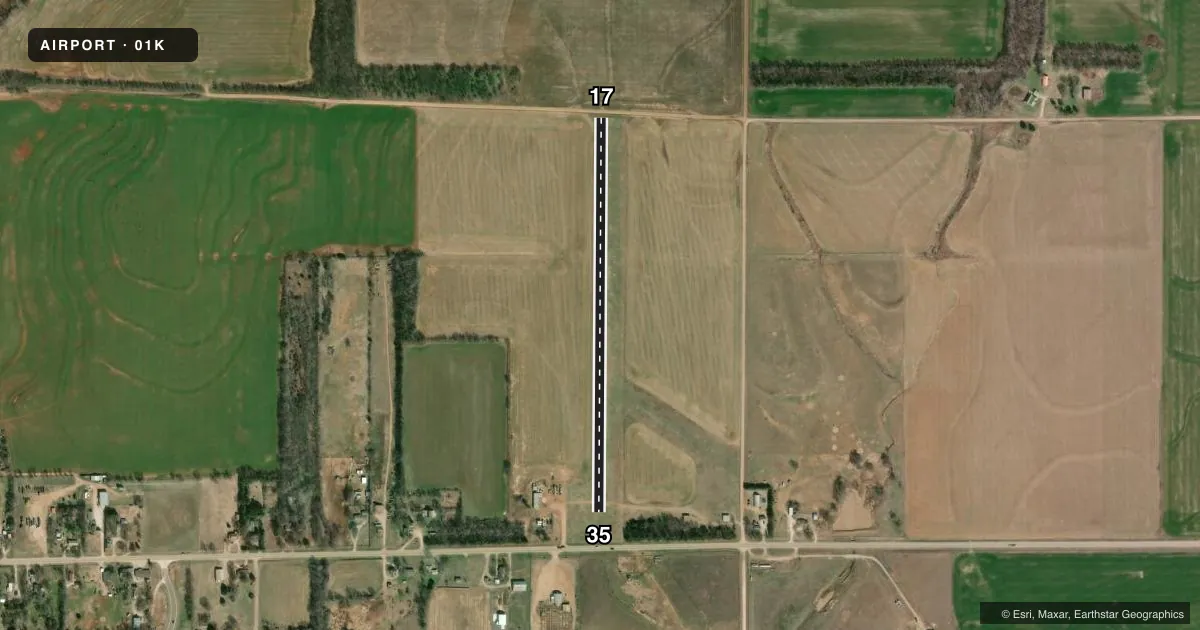
Airport sketch
Runways drawn to scale from FAA survey coordinates, rendered over satellite imagery. Not for navigation.
Approaches & charts
Services on the field
Fuel grades, oxygen, maintenance, ramp storage and lighting — as declared to the FAA by the airport operator.
Fuel & services
- Fuel
- Not available
- Oxygen (bottled)
- Not available
- Oxygen (bulk)
- Not available
- Airframe repair
- Not available
- Power plant repair
- Not available
- Other services
- AGRI
Ramp & ground
- Transient storage
- Tie-down
- Landing fee
- No fee published
- Wind indicator
- Lighted
- Segmented circle
- No
Fuel & FBOs
Cheapest 100LL and Jet A on the field and nearby. Always confirm with the FBO before taxi.
Airport notes
Surface conditions, obstructions, local procedures, lighting outages and other notes published with each FAA cycle.
General notes
- 18 IN BY 140 FT METAL CULVERT IN DITCH E OF RWY ON TWY.
- WIND FARM 5 MI S OF ARPT.
- FOR CD CTC WICHITA APCH AT 316-350-1520.
- RWY 35, SOUTH 300 FT OF RWY ROUGH.
Approach & departure obstructions
- 173 FT DITCH OFF END OF RWY.
- 17DIRT RD N END, EQUIPMENT CROSSING APCH END DURING HARVEST.
- 35PLINE, HWY & PLINE SUPPORT 1/8 MILE S OF ROAD.
Other notes
- LNDG FEE FOR COMMERCIAL USERS ONLY.
VFR map & nearby airports
VFR sectional. Tap any ICAO chip to open that airport.
Key facts · 01K
Answer card- ICAO
- 01K
- Name
- CALDWELL MUNI
- Location
- CALDWELL, KANSAS
- Elevation
- 1,157 ft MSL
- Traffic pattern altitude
- 2,157 ft MSL (1,000 AGL)
- Control tower
- Non-towered (use CTAF)
- Total runways
- 1
- Longest runway
- 17/35 · 2,460 ft
- Published ILS approaches
- 0
- Published frequencies
- 1
- Magnetic variation
- 7°
- Current flight rules
- VFR
- Current wind
- 170° at 13 kt
- Favored runway now
- RWY 17
Caldwell Muni sits in Caldwell, Kansas. The field elevation is 1,157 ft MSL. It has one runway. Runway 17/35 is 2,460 ft of turf, so performance planning matters if you are bringing a heavier airplane or operating on a soft surface.
There is no control tower. CTAF is 122.9. No ILS approaches are published here. The pattern altitude is not published in the facts, so use the standard 1,000 ft AGL for light piston traffic unless the current FAA Chart Supplement says otherwise. That puts the pattern at 2,157 ft MSL based on the listed field elevation.
The published remarks matter here. The south 300 ft of Runway 35 is rough. There is also a dirt road at the north end with equipment crossing the approach end during harvest. Runway 17 has a 3 ft ditch off the end. South of the road on the Runway 35 side, there are power line and highway obstructions. A metal culvert sits in the ditch east of the runway on the taxiway. There is also a wind farm 5 miles south of the airport.
No on-field FBOs are listed. Contact the airport operator directly before arrival, or call the field on CTAF for current service details. For clearance delivery, Wichita Approach is listed in the remarks. Commercial users should also note the published landing fee remark.