METAR & TAF 9K8
9K8 does not publish a METAR.
Showing the nearest reporting station: KHUT (HUTCHINSON RGNL) · 26.9 NM away. Conditions at 9K8 may differ.
METAR · KHUT
Observed 15:52Z
KHUT 271552Z 19013G21KT 10SM CLR 34/18 A2985 RMK AO2 SLP078 T03440183
- Wind
- 190° @ 13G21 kt
- Visibility
- 10 SM
- Temp / Dew
- 34°C / 18°C
- Altimeter
- 29.85 inHg
- Clouds
- CLR
- Density alt
- 4,359 ft
- Ceiling
- Unlimited
- Rules
- VFR
Airport info & contacts
Manager on record, flight service, ARTCC, attendance schedule and pattern altitude — published by the FAA and refreshed every 28 days.
Location
- From city
- 1 NM NW
- VFR sectional
- WICHITA
- ARTCC
- ZKC · KANSAS CITY
- NOTAM facility
- ICT (NOTAM-D)
Airport manager
- Name
- TIM GULLION
- Phone
- 620-532-1279
- Address
- PO BOX 262, KINGMAN KS 67068
Flight service · Hours
- FSS ICT
- WICHITA1-800-WX-BRIEF
- Attendance
- MON-FRI · 0830-2000
Frequencies
Tap any row to copy the frequency to your clipboard.
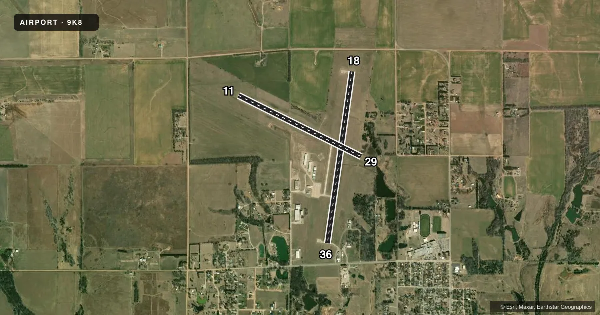
Runways & pattern
Full pagePattern entry · RWY 18
RIGHT TRAFFIC| Runway | Heading (°M) | Length | Surface | Traffic |
|---|---|---|---|---|
| 18/36Favored | 182° / 2° | 4,300 ft | CONC | 18 R |
| 11/29 | 110° / 290° | 3,400 ft | CONC | 29 R |
Runway end performance
| End | TORA | TODA | ASDA | LDA | VGSI | Approach lights | Obstruction |
|---|---|---|---|---|---|---|---|
| 18 | 4,300' | 4,300' | 4,300' | 4,300' | PAPI 2-box left(3°) | — | 15', road, 550' from thr, 0' R of cntrln, slope 24 |
| 36 | 4,300' | 4,300' | 4,300' | 4,300' | PAPI 2-box left(3°) | — | 45', trees, 1290' from thr, 0' R of cntrln, slope 24 |
| 11 | 3,400' | 3,400' | 3,400' | 3,400' | — | — | 37', trees, 1362' from thr, 365' R of cntrln, slope 31 |
| 29 | 3,400' | 3,400' | 3,400' | 3,400' | — | — | — |
Declared distances in feet. TORA = takeoff run available, TODA = takeoff distance, ASDA = accelerate-stop, LDA = landing distance.
Airport sketch
Runways drawn to scale from FAA survey coordinates, rendered over satellite imagery. Not for navigation.
Approaches & charts
Services on the field
Fuel grades, oxygen, maintenance, ramp storage and lighting — as declared to the FAA by the airport operator.
Fuel & services
- Fuel
- 100LL
- Oxygen (bottled)
- Not available
- Oxygen (bulk)
- Not available
- Airframe repair
- Major
- Power plant repair
- Major
- Other services
- AGRI,INSTR,RNTL
Ramp & ground
- Transient storage
- Tie-down
- Hangar
- Landing fee
- No fee published
- Lighting schedule
- SEE RMK
- Beacon schedule
- SS-SR
- Beacon
- White / Green (civil land)(WG)
- Wind indicator
- Lighted
- Segmented circle
- Yes
Fuel & FBOs
Cheapest 100LL and Jet A on the field and nearby. Always confirm with the FBO before taxi.
Airport notes
Surface conditions, obstructions, local procedures, lighting outages and other notes published with each FAA cycle.
General notes
- FOR CD CTC WICHITA APCH AT 316-350-1520.
Lighting notes
- ACTVT REIL RWY 18 & 36; PAPI RWY 18 & 36; MIRL 18/36 - CTAF.
Fuel notes
- 100LLSELF SVC FUEL.
Approach & departure obstructions
- 29POWER LINE MARKED WITH ORANGE BALLS.
VFR map & nearby airports
VFR sectional. Tap any ICAO chip to open that airport.
Key facts · 9K8
Answer card- ICAO
- 9K8
- Name
- KINGMAN/CLYDE CESSNA FLD
- Location
- KINGMAN, KANSAS
- Elevation
- 1,606.6 ft MSL
- Traffic pattern altitude
- 2,606.6 ft MSL (1,000 AGL)
- Control tower
- Non-towered (use CTAF)
- Total runways
- 2
- Longest runway
- 18/36 · 4,300 ft
- Published ILS approaches
- 0
- Published frequencies
- 4
- Magnetic variation
- 6°
- Current flight rules
- VFR
- Current wind
- 190° at 13 kt
- Favored runway now
- RWY 18
Kingman/Clyde Cessna Fld sits in Kingman, Kansas. Field elevation is 1,606.6 ft MSL. The airport has two concrete runways. Runway 18/36 is the longest at 4,300 ft. Runway 11/29 is 3,400 ft. The field is non-towered, so plan to self-announce on CTAF 122.8. No ILS approaches are published here. Pattern altitude is not published, so use the standard 1,000 ft AGL for light piston ops unless the current Chart Supplement says otherwise.
Kingman Airport is the on-field FBO. It carries 100LL and Jet A. Self-serve 100LL is available. For clearance delivery, Wichita Approach is the contact listed in the published remarks. Runway 18 and 36 have runway end identifier lights and PAPI. Medium intensity runway lights are also on 18 and 36. A marked power line is near runway 29, so give that end extra attention on arrival and departure.
This is a Kansas field with modest elevation. Density altitude can still matter in warm weather. Check performance before takeoff. If you need current noise, curfew, or special operating guidance, verify it in the current FAA Chart Supplement or with the airport operator before you go.