METAR & TAF 3TA
3TA does not publish a METAR.
Showing the nearest reporting station: KPTT (PRATT RGNL) · 16.0 NM away. Conditions at 3TA may differ.
METAR · KPTT
Observed 16:35Z
KPTT 271635Z AUTO 21012G15KT 10SM CLR 37/16 A2988 RMK AO2 T03710162
- Wind
- 210° @ 12G15 kt
- Visibility
- 10 SM
- Temp / Dew
- 37°C / 16°C
- Altimeter
- 29.88 inHg
- Clouds
- CLR
- Density alt
- 5,028 ft
- Ceiling
- Unlimited
- Rules
- VFR
Airport info & contacts
Manager on record, flight service, ARTCC, attendance schedule and pattern altitude — published by the FAA and refreshed every 28 days.
Location
- From city
- 3 NM W
- VFR sectional
- WICHITA
- ARTCC
- ZKC · KANSAS CITY
- NOTAM facility
- ICT (NOTAM-D)
Airport manager
- Name
- SHAWN BURGEY
- Phone
- (620) 234-5011
- Address
- 112 W. BROADWAY, BOX 280, STAFFORD KS 67578
Flight service · Hours
- FSS ICT
- WICHITA1-800-WX-BRIEF
- Attendance
- Unattended
Frequencies
Tap any row to copy the frequency to your clipboard.
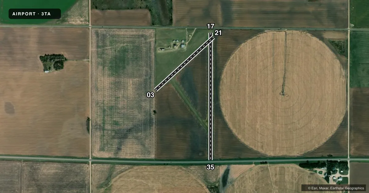
Runways & pattern
Full pagePattern entry · RWY 21
LEFT TRAFFIC| Runway | Heading (°M) | Length | Surface | Traffic |
|---|---|---|---|---|
| 17/35 | 172° / 352° | 2,560 ft | TURF | Standard L |
| 03/21Favored | 39° / 219° | 1,580 ft | TURF | Standard L |
Runway end performance
| End | TORA | TODA | ASDA | LDA | VGSI | Approach lights | Obstruction |
|---|---|---|---|---|---|---|---|
| 17 | — | — | — | — | — | — | 15', road, 15' from thr, 0' R of cntrln, slope 0 |
| 35 | — | — | — | — | — | — | 15', road, 50' from thr, 0' R of cntrln, slope 3 |
| 21 | — | — | — | — | — | — | 15', road, 51' from thr, 0' R of cntrln, slope 3 |
Declared distances in feet. TORA = takeoff run available, TODA = takeoff distance, ASDA = accelerate-stop, LDA = landing distance.
Airport sketch
Runways drawn to scale from FAA survey coordinates, rendered over satellite imagery. Not for navigation.
Approaches & charts
Services on the field
Fuel grades, oxygen, maintenance, ramp storage and lighting — as declared to the FAA by the airport operator.
Fuel & services
- Fuel
- Not available
- Oxygen (bottled)
- Not available
- Oxygen (bulk)
- Not available
- Airframe repair
- Not available
- Power plant repair
- Not available
Ramp & ground
- Transient storage
- Tie-down
- Hangar
- Landing fee
- No fee published
- Beacon schedule
- SS-SR
- Beacon
- White / Green (civil land)(WG)
- Wind indicator
- Lighted
- Segmented circle
- No
Fuel & FBOs
Cheapest 100LL and Jet A on the field and nearby. Always confirm with the FBO before taxi.
Airport notes
Surface conditions, obstructions, local procedures, lighting outages and other notes published with each FAA cycle.
General notes
- FOR CD CTC KANSAS CITY ARTCC AT 913-254-8508.
Approach & departure obstructions
- 13CONTROLLING OBSTN EXCEEDS A 45 DEG SLP.
- 17CONTROLLING OBSTN EXCEEDS A 45 DEG SLP.
- 13PIPE GUARD FENCE AROUND GAS METER AT THRESHOLD.
Other notes
- EXISTED PRIOR TO 1959.
- 13/31FIRST 700 FT OF RY 31 WET & SOFT AFTER RAIN.
- 17/35FIRST 1200 FT OF RY 35 SOFT & WET AFTER RAIN.
VFR map & nearby airports
VFR sectional. Tap any ICAO chip to open that airport.
Key facts · 3TA
Answer card- ICAO
- 3TA
- Name
- STAFFORD MUNI
- Location
- STAFFORD, KANSAS
- Elevation
- 1,886 ft MSL
- Traffic pattern altitude
- 2,886 ft MSL (1,000 AGL)
- Control tower
- Non-towered (use CTAF)
- Total runways
- 2
- Longest runway
- 17/35 · 2,560 ft
- Published ILS approaches
- 0
- Published frequencies
- 1
- Magnetic variation
- 8°
- Current flight rules
- VFR
- Current wind
- 210° at 12 kt
- Favored runway now
- RWY 21
Stafford Muni sits in Stafford, Kansas. The field elevation is 1,886 ft MSL. It has two turf runways. The longest is runway 17/35 at 2,560 ft. This is an unattended field with no control tower. CTAF is 122.9. No ILS approaches are published.
The pattern altitude is not published. Use the standard 1,000 ft AGL pattern for light piston operations unless the current Chart Supplement says otherwise. That puts the pattern at 2,886 ft MSL based on the field elevation. The airport sits in open Kansas terrain, so wind and surface condition matter more than obstacles on most days. Published remarks call out soft and wet turf after rain on the first 1,200 ft of runway 35. The first 700 ft of runway 31 is also wet and soft after rain. There is a pipe guard fence around a gas meter near the threshold of runway 13. The controlling obstruction for runway 13 exceeds a 45 degree slope. The controlling obstruction for runway 17 also exceeds a 45 degree slope.
No on-field FBOs are listed. Contact the airport operator directly before arrival, or call the field on CTAF for current fuel and service availability. For clearance delivery, Kansas City ARTCC is listed in the remarks. Check the current Chart Supplement for any published noise or curfew restrictions before flying into the field.