METAR & TAF KLYO
Current METAR
Observed 18:55Z
KLYO 271855Z AUTO 18019G22KT 10SM CLR 41/15 A2982 RMK AO2 T04140155
- Wind
- 180° @ 19G22 kt
- Visibility
- 10 SM
- Temp / Dew
- 41°C / 15°C
- Altimeter
- 29.82 inHg
- Clouds
- CLR
- Density alt
- 5,342 ft
- Ceiling
- Unlimited
- Rules
- VFR
Airport info & contacts
Manager on record, flight service, ARTCC, attendance schedule and pattern altitude — published by the FAA and refreshed every 28 days.
Location
- From city
- 1 NM W
- VFR sectional
- WICHITA
- ARTCC
- ZKC · KANSAS CITY
- NOTAM facility
- ICT (NOTAM-D)
Airport manager
- Name
- THOMAS ROBL
- Phone
- 620-257-2231
- Address
- 718 WEST 5TH, LYONS KS 67554
Flight service · Hours
- FSS ICT
- WICHITA1-800-WX-BRIEF
- Attendance
- MON-FRI · 0800-1700
Frequencies
Tap any row to copy the frequency to your clipboard.
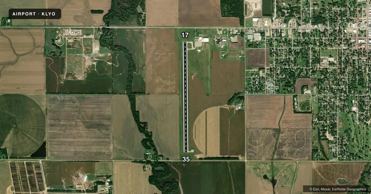
Runways & pattern
Full pagePattern entry · RWY 17
RIGHT TRAFFICRunway end performance
| End | TORA | TODA | ASDA | LDA | VGSI | Approach lights | Obstruction |
|---|---|---|---|---|---|---|---|
| 17 | — | — | — | — | PAPI 2-box left(3°) | — | 15', road, 520' from thr, 0' R of cntrln, slope 21 |
| 35 | — | — | — | — | PAPI 2-box left(3°) | — | 15', road, 335' from thr, 0' R of cntrln, slope 9 |
Declared distances in feet. TORA = takeoff run available, TODA = takeoff distance, ASDA = accelerate-stop, LDA = landing distance.
Airport sketch
Runways drawn to scale from FAA survey coordinates, rendered over satellite imagery. Not for navigation.
Approaches & charts
Services on the field
Fuel grades, oxygen, maintenance, ramp storage and lighting — as declared to the FAA by the airport operator.
Fuel & services
- Fuel
- 100LLA
- Oxygen (bottled)
- Not available
- Oxygen (bulk)
- Not available
- Airframe repair
- Major
- Power plant repair
- Major
- Other services
- AGRI
Ramp & ground
- Transient storage
- Tie-down
- Hangar
- Landing fee
- No fee published
- Customs
- Not available
- Lighting schedule
- SEE RMK
- Beacon schedule
- SS-SR
- Beacon
- White / Green (civil land)(WG)
- Wind indicator
- Lighted
- Segmented circle
- No
Fuel & FBOs
Cheapest 100LL and Jet A on the field and nearby. Always confirm with the FBO before taxi.
Airport notes
Surface conditions, obstructions, local procedures, lighting outages and other notes published with each FAA cycle.
General notes
- FOR CD CTC KANSAS CITY ARTCC AT 913-254-8508.
- COURTESY CAR AVBL.
Lighting notes
- ACTVT REIL RWY 17 & 35; PAPI RWY 17 & 35; MIRL RWY 17/35 - CTAF.
Fuel notes
- 100LLFUEL AVAILABLE DURING NORMAL ATTENDANCE SCHEDULE AFTER HOURS NUMBER 785-577-1918
- AJET A ON REQUEST
Other notes
- 1FOR ATTENDANCE OTR TIMES ON REQ CALL 620-257-5002.
- MANAGERMANAGERS CELL PHONE 785-577-1918
VFR map & nearby airports
VFR sectional. Tap any ICAO chip to open that airport.
Key facts · KLYO
Answer card- ICAO
- KLYO
- Name
- LYONS-RICE COUNTY MUNI
- Location
- LYONS, KANSAS
- Elevation
- 1,691.7 ft MSL
- Traffic pattern altitude
- 2,691.7 ft MSL (1,000 AGL)
- Control tower
- Non-towered (use CTAF)
- Total runways
- 1
- Longest runway
- 17/35 · 4,400 ft
- Published ILS approaches
- 0
- Published frequencies
- 2
- Magnetic variation
- 6°
- Current flight rules
- VFR
- Current wind
- 180° at 19 kt
- Favored runway now
- RWY 17
LYONS-RICE COUNTY MUNI sits in Lyons, Kansas. The field elevation is 1,691.7 ft MSL. It has one runway, 17/35, which is 4,400 ft long with concrete pavement. There is no control tower. CTAF and UNICOM are both 122.8.
No ILS approaches are published here. The pattern altitude is not published in the facts, so use the current Chart Supplement before you fly. The runway lighting is pilot-controlled on CTAF. Runway end identifier lights are installed on 17 and 35. Precision approach path indicators are also available on both ends.
The on-field FBO is Lyons-Rice County Municipal Airport. It carries AVGAS 100LL and Jet A. 100LL is available during normal attendance hours. For after-hours fuel or attendance, call the numbers in the Chart Supplement or the airport manager. A courtesy car is available.
This is a non-towered field with a single runway, so get the local picture before arrival. Clearance delivery is handled through Kansas City Center. Check the current Chart Supplement for any published noise or curfew restrictions before flying in. The published remarks also note that attendance can be arranged by request outside regular times.