METAR & TAF KMPR
Current METAR
Observed 18:35Z
KMPR 271835Z AUTO 18015G19KT 10SM CLR 40/18 A2982 RMK AO2 T03960185
- Wind
- 180° @ 15G19 kt
- Visibility
- 10 SM
- Temp / Dew
- 40°C / 18°C
- Altimeter
- 29.82 inHg
- Clouds
- CLR
- Density alt
- 4,982 ft
- Ceiling
- Unlimited
- Rules
- VFR
Airport info & contacts
Manager on record, flight service, ARTCC, attendance schedule and pattern altitude — published by the FAA and refreshed every 28 days.
Location
- From city
- 1 NM SW
- VFR sectional
- WICHITA
- ARTCC
- ZKC · KANSAS CITY
- NOTAM facility
- ICT (NOTAM-D)
Airport manager
- Name
- CYNTHIA PETERSON
- Phone
- 620-241-0684
- Address
- 1000 S. 81 BYPASS, MC PHERSON KS 67460
Flight service · Hours
- FSS ICT
- WICHITA1-800-WX-BRIEF
- Attendance
- MON-FRI · 0800-1700
- SAT · 0800-1200
Frequencies
Tap any row to copy the frequency to your clipboard.
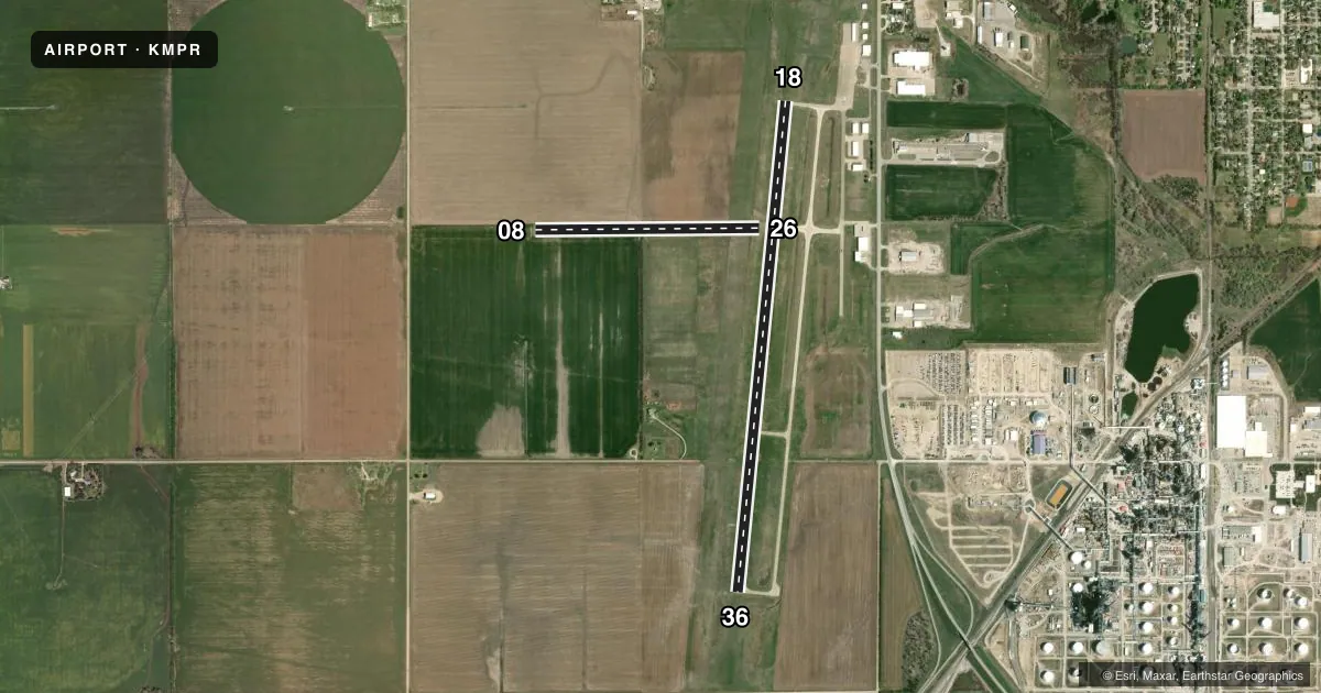
Runways & pattern
Full pagePattern entry · RWY 18
RIGHT TRAFFIC| Runway | Heading (°M) | Length | Surface | Traffic |
|---|---|---|---|---|
| 18/36Favored | 180° / 0° | 5,503 ft | CONC | 18 R |
| 08/26 | 84° / 264° | 2,502 ft | TURF | 26 R |
Runway end performance
| End | TORA | TODA | ASDA | LDA | VGSI | Approach lights | Obstruction |
|---|---|---|---|---|---|---|---|
| 18 | — | — | — | — | PAPI 4-box left(3°) | — | — |
| 36 | — | — | — | — | PAPI 4-box left(3°) | — | — |
Declared distances in feet. TORA = takeoff run available, TODA = takeoff distance, ASDA = accelerate-stop, LDA = landing distance.
Airport sketch
Runways drawn to scale from FAA survey coordinates, rendered over satellite imagery. Not for navigation.
Approaches & charts
Services on the field
Fuel grades, oxygen, maintenance, ramp storage and lighting — as declared to the FAA by the airport operator.
Fuel & services
- Fuel
- 100LLAMOGAS
- Oxygen (bottled)
- Not available
- Oxygen (bulk)
- Not available
- Airframe repair
- Major
- Power plant repair
- Major
- Other services
- INSTR,RNTL,SALES
Ramp & ground
- Transient storage
- Tie-down
- Hangar
- Landing fee
- No fee published
- Customs
- Not available
- Lighting schedule
- SEE RMK
- Beacon schedule
- SS-SR
- Beacon
- White / Green (civil land)(WG)
- Wind indicator
- Lighted
- Segmented circle
- Yes
Fuel & FBOs
Cheapest 100LL and Jet A on the field and nearby. Always confirm with the FBO before taxi.
Airport notes
Surface conditions, obstructions, local procedures, lighting outages and other notes published with each FAA cycle.
General notes
- PHONE AVBL 24 HRS.
- +300 FOOT CONSTRUCTION CRANES OCCASIONALLY AT REFINERY .9 MILES EAST SOUTHEAST OF AIRPORT
- AWOS (620) 241-2498 FREQ. 119.025
- FOR CD IF UNA TO CTC ON FSS FREQ, CTC WICHITA APPCH AT 316-350-1520
Lighting notes
- MIRL RY 18/36 PRESET ON LOW INTST TO INCREASE INTST ACTVT - CTAF.
Fuel notes
- 100LL100LL IS AVBL BY USE OF CREDIT CARD. JET A AND MO GAS AFTER HOURS CALL MANAGER 620-755-8901
Approach & departure obstructions
- 08RWY 08 THLD AND EDGE DELINEATED BY YELLOW CONES.
- 26RWY 26 THLD AND EDGE DELINEATED WITH YELLOW CONES.
Other notes
- 18/36PORTIONS OF TWYS & TIE DOWN AREAS ARE A COMBINATION OF CONCRETE & ASPHALT.
VFR map & nearby airports
VFR sectional. Tap any ICAO chip to open that airport.
Key facts · KMPR
Answer card- ICAO
- KMPR
- Name
- MC PHERSON
- Location
- MC PHERSON, KANSAS
- Elevation
- 1,498.3 ft MSL
- Traffic pattern altitude
- 2,498.3 ft MSL (1,000 AGL)
- Control tower
- Non-towered (use CTAF)
- Total runways
- 2
- Longest runway
- 18/36 · 5,503 ft
- Published ILS approaches
- 0
- Published frequencies
- 4
- Magnetic variation
- 6°
- Current flight rules
- VFR
- Current wind
- 180° at 15 kt
- Favored runway now
- RWY 18
Mc Pherson Airport sits in Mc Pherson, Kansas. The field elevation is 1,498.3 ft MSL. It has two runways. The longest is 18/36 at 5,503 ft. There is no control tower. Traffic uses CTAF 122.8. No ILS approaches are published. The pattern altitude is not published, so use the standard 1,000 ft AGL for light piston traffic unless the current Chart Supplement says otherwise.
The on-field FBO is McPherson Airport Authority. It carries 100LL, Jet A Prist and mogas. 100LL is available by credit card. Jet A and mogas are available after hours by calling the manager. The airport also has AWOS on 119.025 with a published phone number. Phone service is available 24 hours.
For a first-time arrival, note the runway lighting on 18/36. The medium intensity lights are preset on low intensity. Use CTAF to increase intensity. Runway 08 and runway 26 are marked with yellow cones at the threshold and edge. Portions of the taxiways and tie down areas are a mix of concrete and asphalt. There are also construction cranes about 0.9 miles east southeast of the airport. Check your situational awareness on the approach. This matters in daylight when the cones and surface changes stand out.