METAR & TAF 47K
47K does not publish a METAR.
Showing the nearest reporting station: KMPR (MC PHERSON) · 12.4 NM away. Conditions at 47K may differ.
METAR · KMPR
Observed 13:35Z
KMPR 271335Z AUTO 18011KT 10SM SCT120 27/20 A2987 RMK AO2 T02740197
- Wind
- 180° @ 11 kt
- Visibility
- 10 SM
- Temp / Dew
- 27°C / 20°C
- Altimeter
- 29.87 inHg
- Clouds
- SCT
- Density alt
- 3,348 ft
- Ceiling
- Unlimited
- Rules
- VFR
Airport info & contacts
Manager on record, flight service, ARTCC, attendance schedule and pattern altitude — published by the FAA and refreshed every 28 days.
Location
- From city
- 1 NM E
- VFR sectional
- WICHITA
- ARTCC
- ZKC · KANSAS CITY
- NOTAM facility
- ICT (NOTAM-D)
Airport manager
- Name
- MIKE STRAUSZ
- Phone
- 620-345-1281
- Address
- 225 SOUTH CHRISTIAN AVENUE, MOUNDRIDGE KS 67107
Flight service · Hours
- FSS ICT
- WICHITA1-800-WX-BRIEF
- Attendance
- MON - FRI · 0800-1700
Frequencies
Tap any row to copy the frequency to your clipboard.
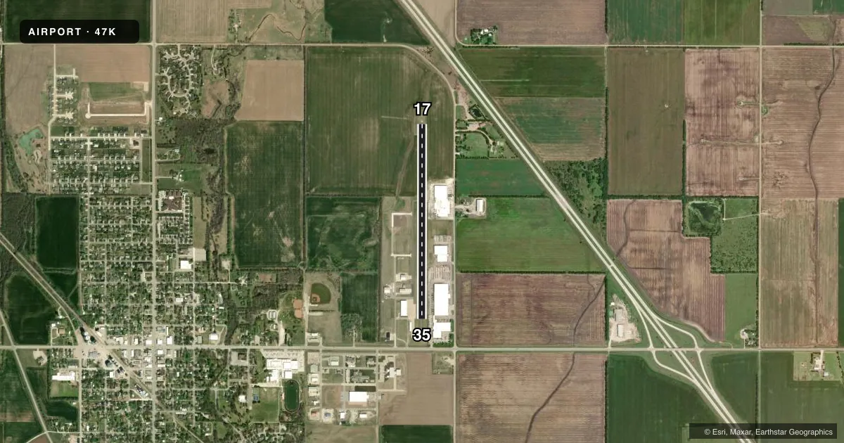
Runways & pattern
Full pagePattern entry · RWY 17
LEFT TRAFFICRunway end performance
| End | TORA | TODA | ASDA | LDA | VGSI | Approach lights | Obstruction |
|---|---|---|---|---|---|---|---|
| 17 | — | — | — | — | — | — | 25', trees, 925' from thr, 82' R of cntrln, slope 29 |
| 35 | — | — | — | — | — | — | 20', bldg, 201' from thr, 173' R of cntrln, slope 0 |
Declared distances in feet. TORA = takeoff run available, TODA = takeoff distance, ASDA = accelerate-stop, LDA = landing distance.
Airport sketch
Runways drawn to scale from FAA survey coordinates, rendered over satellite imagery. Not for navigation.
Approaches & charts
Services on the field
Fuel grades, oxygen, maintenance, ramp storage and lighting — as declared to the FAA by the airport operator.
Fuel & services
- Fuel
- 100LLMOGAS
- Airframe repair
- Not available
- Power plant repair
- Not available
- Other services
- AGRI,CHTR,SALES
Ramp & ground
- Transient storage
- Tie-down
- Hangar
- Landing fee
- No fee published
- Beacon schedule
- SS-SR
- Beacon
- White / Green (civil land)(WG)
- Wind indicator
- Yes
- Segmented circle
- No
Fuel & FBOs
Cheapest 100LL and Jet A on the field and nearby. Always confirm with the FBO before taxi.
Airport notes
Surface conditions, obstructions, local procedures, lighting outages and other notes published with each FAA cycle.
General notes
- FOR CD CTC WICHITA APCH AT 316-350-1520.
Fuel notes
- 100LLFUEL 24 HR SELF SERVE.
Approach & departure obstructions
- 1720 FT BLDG, 0-199 FT DSTC, 204 FT R. 55 FT RTG BCN, 67 FT DSTC, 214 FT L.
Other notes
- PROVIDED APCH TO EACH RWY IS MAINTAINED FOR A MIN 20:1 GLIDE SLOPE AND THE TRANSITIONAL SURFACE BE MAINTAINED FOR A 7:1 SLOPE.
- OWNERAMGR CELL.
VFR map & nearby airports
VFR sectional. Tap any ICAO chip to open that airport.
Key facts · 47K
Answer card- ICAO
- 47K
- Name
- MOUNDRIDGE MUNI
- Location
- MOUNDRIDGE, KANSAS
- Elevation
- 1,489 ft MSL
- Traffic pattern altitude
- 2,489 ft MSL (1,000 AGL)
- Control tower
- Non-towered (use CTAF)
- Total runways
- 1
- Longest runway
- 17/35 · 3,405 ft
- Published ILS approaches
- 0
- Published frequencies
- 3
- Magnetic variation
- 7°
- Current flight rules
- VFR
- Current wind
- 180° at 11 kt
- Favored runway now
- RWY 17
Moundridge Muni sits in Moundridge, Kansas. Field elevation is 1,489 ft MSL. The airport has one runway. Runway 17/35 is 3,405 ft long with an asphalt surface. The field is non-towered. No ILS approaches are published here. Pattern altitude is not published, so plan on the standard 1,000 ft AGL for light piston traffic unless the current Chart Supplement says otherwise.
The on-field FBO is Moundridge Municipal Airport. It carries 100LL and MOGAS. Fuel is available 24 hours self-serve. That is useful if you are arriving outside normal business hours. The published remarks also note an obstruction near runway 17. There is a building off the departure end area on the right side. There is also a rotating beacon close to the runway on the left side. Give the departure path a careful look before you go.
Wichita Approach handles clearance delivery and approach support here. The published remarks list a clearance delivery phone number. Check the current Chart Supplement for the latest procedures before you fly in. This is a small Kansas field with one runway, so expect straightforward operations. Still, review the runway layout, the obstruction notes and the current airspace picture before arrival.