METAR & TAF M66
M66 does not publish a METAR.
Showing the nearest reporting station: KEWK (NEWTON-CITY-COUNTY) · 17.3 NM away. Conditions at M66 may differ.
METAR · KEWK
Observed 16:56Z
KEWK 271656Z AUTO 19011KT 10SM CLR 35/21 A2987 RMK AO2 SLP093 T03500206 $
- Wind
- 190° @ 11 kt
- Visibility
- 10 SM
- Temp / Dew
- 35°C / 21°C
- Altimeter
- 29.87 inHg
- Clouds
- CLR
- Density alt
- 4,240 ft
- Ceiling
- Unlimited
- Rules
- VFR
Airport info & contacts
Manager on record, flight service, ARTCC, attendance schedule and pattern altitude — published by the FAA and refreshed every 28 days.
Location
- From city
- 0 NM SW
- VFR sectional
- WICHITA
- ARTCC
- ZKC · KANSAS CITY
- NOTAM facility
- ICT (NOTAM-D)
Airport manager
- Name
- MATT STILES
- Phone
- 620-947-3162
- Address
- 118 EAST GRAND, HILLSBORO KS 67063
Flight service · Hours
- FSS ICT
- WICHITA1-800-WX-BRIEF
- Attendance
- Unattended
Frequencies
Tap any row to copy the frequency to your clipboard.
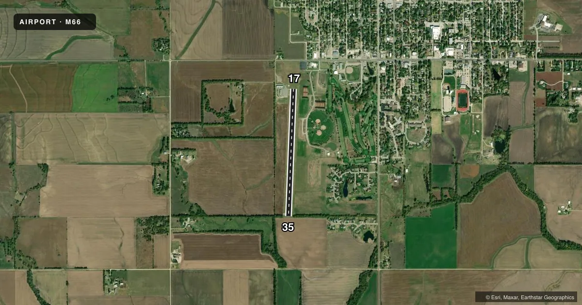
Runways & pattern
Full pagePattern entry · RWY 17
LEFT TRAFFICRunway end performance
| End | TORA | TODA | ASDA | LDA | VGSI | Approach lights | Obstruction |
|---|---|---|---|---|---|---|---|
| 17 | — | — | — | — | PAPI 4-box left(3.75°) | — | 15', road, 704' from thr, 0' R of cntrln, slope 33 |
| 35 | — | — | — | — | PAPI 4-box left(3.75°) | — | 38', trees, 1164' from thr, 72' R of cntrln, slope 25 |
Declared distances in feet. TORA = takeoff run available, TODA = takeoff distance, ASDA = accelerate-stop, LDA = landing distance.
Airport sketch
Runways drawn to scale from FAA survey coordinates, rendered over satellite imagery. Not for navigation.
Approaches & charts
Services on the field
Fuel grades, oxygen, maintenance, ramp storage and lighting — as declared to the FAA by the airport operator.
Fuel & services
- Fuel
- 100LL
- Oxygen (bottled)
- Not available
- Oxygen (bulk)
- Not available
- Airframe repair
- Not available
- Power plant repair
- Not available
Ramp & ground
- Transient storage
- Tie-down
- Hangar
- Landing fee
- No fee published
- Lighting schedule
- SEE RMK
- Beacon schedule
- SS-SR
- Beacon
- White / Green (civil land)(WG)
- Wind indicator
- Yes
- Segmented circle
- No
Fuel & FBOs
Cheapest 100LL and Jet A on the field and nearby. Always confirm with the FBO before taxi.
Airport notes
Surface conditions, obstructions, local procedures, lighting outages and other notes published with each FAA cycle.
General notes
- ULTRALIGHT ACTIVITY INVOF ARPT.
- PHONE AVBL 24 HRS IN PILOTS LOUNGE; 620-416-6102
- FOR CD CTC WICHITA APCH AT 316-350-1520.
Lighting notes
- ACTVT PAPI RWY 17 & 35, LIRL RWY 17/35; - CTAF.
Fuel notes
- 100LL100LL FUEL 24 HR SELF-SERVE.
Approach & departure obstructions
- 35RWY 35, 28 FT TREES, 0 FT DSTC, 120 FT L/R.
Other notes
- PROVIDED A CLEAR APPROACH TO EACH RWY IS MAINTAINED FOR A MINIMUM 20:1 GLIDE SLOPE AND THE TRANSITIONAL SURFACE IS MAINTAINED FOR A 7:1 SLOPE.
- MANAGERCITY ADMIN/AMGR.
VFR map & nearby airports
VFR sectional. Tap any ICAO chip to open that airport.
Key facts · M66
Answer card- ICAO
- M66
- Name
- ALFRED SCHROEDER FLD
- Location
- HILLSBORO, KANSAS
- Elevation
- 1,434 ft MSL
- Traffic pattern altitude
- 2,434 ft MSL (1,000 AGL)
- Control tower
- Non-towered (use CTAF)
- Total runways
- 1
- Longest runway
- 17/35 · 3,229 ft
- Published ILS approaches
- 0
- Published frequencies
- 1
- Magnetic variation
- 7°
- Current flight rules
- VFR
- Current wind
- 190° at 11 kt
- Favored runway now
- RWY 17
Alfred Schroeder Fld sits in Hillsboro, Kansas. The field elevation is 1,434 ft MSL. It has one runway. Runway 17/35 is 3,229 ft asphalt, so plan your performance with that length in mind. There is no control tower. CTAF is 122.9. No ILS approaches are published here.
The published pattern altitude is not listed, so use the standard 1,000 ft AGL unless the current Chart Supplement says otherwise. That puts the light piston pattern at 2,434 ft MSL based on the field elevation. For departure or arrival planning, note the published clearance note to contact Wichita Approach at 316-350-1520 for clearance delivery. The airport also has ultralight activity in the area, so keep a sharp scan in the pattern and on final.
The on-field FBO is Alfred Schroeder Field. It carries AVGAS 100LL. 100LL is available 24 hours by self-service. A phone is available 24 hours in the pilots lounge at 620-416-6102. Runway 35 has trees near the threshold area, with 28 ft trees noted close to the runway centerline area. PAPI and low intensity runway lights on 17 and 35 are activated by using the CTAF. For any noise or local operating details that are not published here, check the current FAA Chart Supplement before you go.