METAR & TAF 43K
43K does not publish a METAR.
Showing the nearest reporting station: KEWK (NEWTON-CITY-COUNTY) · 21.6 NM away. Conditions at 43K may differ.
METAR · KEWK
Observed 02:56Z
KEWK 270256Z AUTO 16011KT 10SM CLR 31/22 A2988 RMK AO2 SLP096 T03110217 53006 $
- Wind
- 160° @ 11 kt
- Visibility
- 10 SM
- Temp / Dew
- 31°C / 22°C
- Altimeter
- 29.88 inHg
- Clouds
- CLR
- Density alt
- 3,693 ft
- Ceiling
- Unlimited
- Rules
- VFR
Airport info & contacts
Manager on record, flight service, ARTCC, attendance schedule and pattern altitude — published by the FAA and refreshed every 28 days.
Location
- From city
- 2 NM SE
- VFR sectional
- KANSAS CITY
- ARTCC
- ZKC · KANSAS CITY
- NOTAM facility
- ICT (NOTAM-D)
Airport manager
- Name
- BRIAN WELLS
- Phone
- 620-382-3703
- Address
- 208 EAST SANTA FE, MARION KS 66861
Flight service · Hours
- FSS ICT
- WICHITA1-800-WX-BRIEF
- Attendance
- Unattended
Frequencies
Tap any row to copy the frequency to your clipboard.
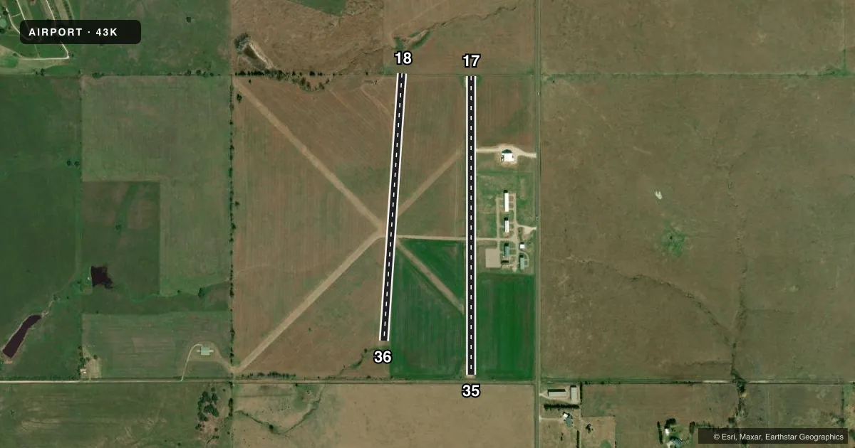
Runways & pattern
Full pagePattern entry · RWY 17
LEFT TRAFFIC| Runway | Heading (°M) | Length | Surface | Traffic |
|---|---|---|---|---|
| 17/35Favored | 173° / 353° | 2,573 ft | ASPH | Standard L |
| 18/36 | 177° / 357° | 2,310 ft | TURF | Standard L |
Runway end performance
| End | TORA | TODA | ASDA | LDA | VGSI | Approach lights | Obstruction |
|---|---|---|---|---|---|---|---|
| 36 | — | — | — | — | — | — | 15', tree, 0' from thr, 62' R of cntrln, slope 0 |
Declared distances in feet. TORA = takeoff run available, TODA = takeoff distance, ASDA = accelerate-stop, LDA = landing distance.
Airport sketch
Runways drawn to scale from FAA survey coordinates, rendered over satellite imagery. Not for navigation.
Approaches & charts
Services on the field
Fuel grades, oxygen, maintenance, ramp storage and lighting — as declared to the FAA by the airport operator.
Fuel & services
- Fuel
- 100LLMOGAS
- Oxygen (bottled)
- Not available
- Oxygen (bulk)
- Not available
- Airframe repair
- Not available
- Power plant repair
- Not available
Ramp & ground
- Transient storage
- Tie-down
- Hangar
- Landing fee
- No fee published
- Beacon schedule
- SS-SR
- Beacon
- White / Green (civil land)(WG)
- Wind indicator
- Yes
- Segmented circle
- No
Fuel & FBOs
Cheapest 100LL and Jet A on the field and nearby. Always confirm with the FBO before taxi.
Airport notes
Surface conditions, obstructions, local procedures, lighting outages and other notes published with each FAA cycle.
General notes
- FOR CD CTC KANSAS CITY ARTCC AT 913-254-8508.
Approach & departure obstructions
- 174 FT FENCE, 30 FT DSTC, 30 FT L & R.
- 03CONTROLLING OBSTN EXCEEDS A 45 DEG SLP.
- 13CONTROLLING OBSTN EXCEEDS A 45 DEG SLP.
- 18CONTROLLING OBSTN EXCEEDS A 45 DEG SLP.
Other notes
- MANAGERCITY/AMGR.
VFR map & nearby airports
VFR sectional. Tap any ICAO chip to open that airport.
Key facts · 43K
Answer card- ICAO
- 43K
- Name
- MARION MUNI
- Location
- MARION, KANSAS
- Elevation
- 1,390 ft MSL
- Traffic pattern altitude
- 2,390 ft MSL (1,000 AGL)
- Control tower
- Non-towered (use CTAF)
- Total runways
- 2
- Longest runway
- 17/35 · 2,573 ft
- Published ILS approaches
- 0
- Published frequencies
- 1
- Magnetic variation
- 7°
- Current flight rules
- VFR
- Current wind
- 160° at 11 kt
- Favored runway now
- RWY 17
Marion Muni sits in Marion, Kansas. Field elevation is 1,390 ft MSL. The airport has 2 runways. The longest is runway 17/35 at 2,573 ft. There is no control tower. CTAF is 122.9.
No ILS approaches are published here. Pattern altitude is not published, so use the standard 1,000 ft AGL for light piston operations unless the current Chart Supplement says otherwise. That puts the traffic pattern at 2,390 ft MSL based on the field elevation. The paved runway is 17/35. Runway 18/36 is turf at 2,310 ft. Published remarks call out obstacle issues near several runway ends. Runway 17 also has a fence close in on both sides. That makes a careful runway check a good idea before landing.
There are no on-field FBOs listed in the facts. Contact the airport operator directly or call on CTAF for current services before you go. The airport manager is the city manager. For clearance delivery, Kansas City ARTCC is listed in the remarks. This is a small non-towered field with no published ILS, so plan your arrival with the current Chart Supplement and be ready for local traffic on CTAF.