METAR & TAF KEMP
Current METAR
Observed 19:53Z
KEMP 271953Z AUTO 21016G22KT 10SM CLR 37/22 A2980 RMK AO2 SLP078 T03720217
- Wind
- 210° @ 16G22 kt
- Visibility
- 10 SM
- Temp / Dew
- 37°C / 22°C
- Altimeter
- 29.80 inHg
- Clouds
- CLR
- Density alt
- 4,286 ft
- Ceiling
- Unlimited
- Rules
- VFR
Airport info & contacts
Manager on record, flight service, ARTCC, attendance schedule and pattern altitude — published by the FAA and refreshed every 28 days.
Location
- From city
- 4 NM S
- VFR sectional
- KANSAS CITY
- ARTCC
- ZKC · KANSAS CITY
- NOTAM facility
- EMP (NOTAM-D)
Airport manager
- Name
- KEN ADAMS
- Phone
- 620-343-5600
- Address
- 1005 COUNTY RD 120, EMPORIA KS 66801
Flight service · Hours
- FSS ICT
- WICHITA1-800-WX-BRIEF
- Attendance
- 0730-1730
Frequencies
Tap any row to copy the frequency to your clipboard.
Runways & pattern
Full pagePattern entry · RWY 19
LEFT TRAFFIC| Runway | Heading (°M) | Length | Surface | Traffic |
|---|---|---|---|---|
| 01/19Favored | 7° / 187° | 5,005 ft | ASPH-CONC | Standard L |
| 06/24 | 60° / 240° | 3,881 ft | TURF | Standard L |
Runway end performance
| End | TORA | TODA | ASDA | LDA | VGSI | Approach lights | Obstruction |
|---|---|---|---|---|---|---|---|
| 01 | — | — | — | — | PAPI 4-box left(3°) | — | — |
| 19 | — | — | — | — | PAPI 4-box left(3°) | — | 35', trees, 856' from thr, 250' R of cntrln, slope 18 |
Declared distances in feet. TORA = takeoff run available, TODA = takeoff distance, ASDA = accelerate-stop, LDA = landing distance.
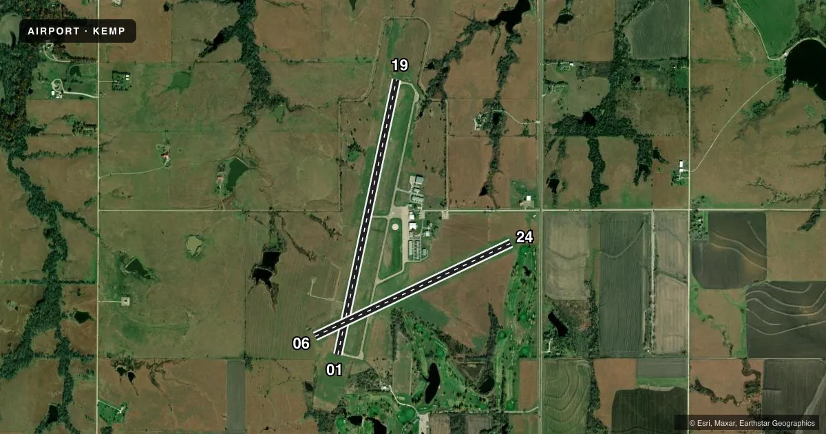
Airport sketch
Runways drawn to scale from FAA survey coordinates, rendered over satellite imagery. Not for navigation.
Approaches & charts
Services on the field
Fuel grades, oxygen, maintenance, ramp storage and lighting — as declared to the FAA by the airport operator.
Fuel & services
- Fuel
- 100LLA1+MOGAS
- Oxygen (bottled)
- Not available
- Oxygen (bulk)
- Not available
- Airframe repair
- Not available
- Power plant repair
- Not available
- Other services
- AVNCS,INSTR,RNTL,SALES
Ramp & ground
- Transient storage
- Tie-down
- Hangar
- Landing fee
- No fee published
- Customs
- Not available
- Lighting schedule
- SEE RMK
- Beacon schedule
- SEE RMK
- Beacon
- White / Green (civil land)(WG)
- Wind indicator
- Lighted
- Segmented circle
- Yes
Fuel & FBOs
Cheapest 100LL and Jet A on the field and nearby. Always confirm with the FBO before taxi.
Airport notes
Surface conditions, obstructions, local procedures, lighting outages and other notes published with each FAA cycle.
General notes
- ULTRALIGHT ACTVTY ON & INVOF ARPT.
- FOR CD IF UNA TO CTC ON FSS FREQ, CTC KANSAS CITY ARTCC AT 913-254-8508.
- RCO AVBL 127.725 KANSAS CITY CTR.
- RWY 6/24 ENDS AND EDGES MARKED WITH ORANGE AND WHITE PANELS.
Lighting notes
- SS-SR.
- ACTVT PAPI & REIL RY 01/19 - CTAF. ACTVT MIRL RY 01/19 AFT 1800 - CTAF.
Fuel notes
- 100LL100 LL & MOGAS 24 HR SELF-SERVE..
- A1+JET A FULL SERVE. AFTR HRS ON REQ.
Runway surface & condition
- 01/19NO LINE OF SIGHT BETWEEN RWY ENDS.
Other notes
- THIS AIRPORT HAS BEEN SURVEYED BY THE NATIONAL GEODETIC SURVEY.
- OWNERCITY MGR, TREY COCKING.
- 06/24SOFT WHEN WET.
VFR map & nearby airports
VFR sectional. Tap any ICAO chip to open that airport.
Key facts · KEMP
Answer card- ICAO
- KEMP
- Name
- EMPORIA MUNI
- Location
- EMPORIA, KANSAS
- Elevation
- 1,207.7 ft MSL
- Traffic pattern altitude
- 2,207.7 ft MSL (1,000 AGL)
- Control tower
- Non-towered (use CTAF)
- Total runways
- 2
- Longest runway
- 01/19 · 5,005 ft
- Published ILS approaches
- 0
- Published frequencies
- 2
- Magnetic variation
- 5°
- Current flight rules
- VFR
- Current wind
- 210° at 16 kt
- Favored runway now
- RWY 19
Emporia Muni sits in Emporia, Kansas. Field elevation is 1,207.7 ft MSL. The airport has two runways. The longest is 01/19 at 5,005 ft. There is no control tower. CTAF and UNICOM are both 122.8.
No ILS approaches are published here. Pattern altitude is not published, so use the standard 1,000 ft AGL for light piston operations unless the current Chart Supplement says otherwise. Emporia Aviation Center is on the field. It carries AVGAS 100LL, Jet A and MOGAS. 100LL and motor gasoline are available 24 hours self-serve. Jet A is full service. After hours service is available on request.
Runway 01/19 has PAPI and REILs controlled by CTAF. Medium intensity runway lights for 01/19 come on after 1800 by CTAF. Runway 6/24 is turf. It is soft when wet. Its ends and edges are marked with orange and white panels. There is no line of sight between the ends of runway 01 and runway 19. Ultralight activity is on and near the airport. If you are new to the field, plan your taxi and runway selection with that in mind. The airport also has a remote communications outlet on 127.725 with Kansas City Center.