METAR & TAF 13K
Current METAR
Observed 20:55Z
K13K 272055Z AUTO 20016KT 10SM CLR 39/21 A2982 RMK AO2 T03870210
- Wind
- 200° @ 16 kt
- Visibility
- 10 SM
- Temp / Dew
- 39°C / 21°C
- Altimeter
- 29.82 inHg
- Clouds
- CLR
- Density alt
- 4,502 ft
- Ceiling
- Unlimited
- Rules
- VFR
Airport info & contacts
Manager on record, flight service, ARTCC, attendance schedule and pattern altitude — published by the FAA and refreshed every 28 days.
Location
- From city
- 2 NM N
- VFR sectional
- KANSAS CITY
- ARTCC
- ZKC · KANSAS CITY
- NOTAM facility
- ICT (NOTAM-D)
Airport manager
Flight service · Hours
- FSS ICT
- WICHITA1-800-WX-BRIEF
- Attendance
- IREG
Frequencies
Tap any row to copy the frequency to your clipboard.
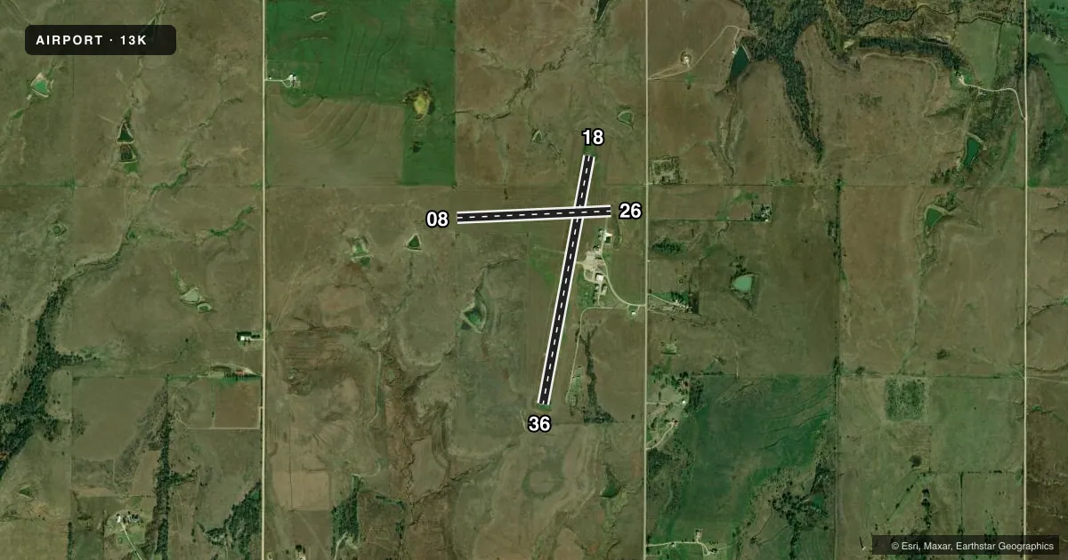
Runways & pattern
Full pagePattern entry · RWY 18
LEFT TRAFFIC| Runway | Heading (°M) | Length | Surface | Traffic |
|---|---|---|---|---|
| 18/36Favored | 189° / 9° | 3,504 ft | ASPH | Standard L |
| 08/26 | 85° / 265° | 2,143 ft | TURF | Standard L |
Runway end performance
| End | TORA | TODA | ASDA | LDA | VGSI | Approach lights | Obstruction |
|---|---|---|---|---|---|---|---|
| 18 | — | — | — | — | PAPI 2-box left(3°) | — | — |
| 36 | — | — | — | — | PAPI 2-box left(3°) | — | — |
| 08 | — | — | — | — | — | — | 4', fence, 0' from thr, 0' R of cntrln, slope 0 |
Declared distances in feet. TORA = takeoff run available, TODA = takeoff distance, ASDA = accelerate-stop, LDA = landing distance.
Airport sketch
Runways drawn to scale from FAA survey coordinates, rendered over satellite imagery. Not for navigation.
Approaches & charts
Services on the field
Fuel grades, oxygen, maintenance, ramp storage and lighting — as declared to the FAA by the airport operator.
Fuel & services
- Fuel
- 100LL
- Oxygen (bottled)
- Not available
- Oxygen (bulk)
- Not available
- Airframe repair
- Not available
- Power plant repair
- Not available
- Other services
- AGRI
Ramp & ground
- Transient storage
- Tie-down
- Landing fee
- No fee published
- Customs
- Not available
- Lighting schedule
- SEE RMK
- Beacon schedule
- SS-SR
- Beacon
- White / Green (civil land)(WG)
- Wind indicator
- Lighted
- Segmented circle
- Yes
Fuel & FBOs
Cheapest 100LL and Jet A on the field and nearby. Always confirm with the FBO before taxi.
Airport notes
Surface conditions, obstructions, local procedures, lighting outages and other notes published with each FAA cycle.
General notes
- WILDLIFE ON & INVOF ARPT.
- FOR CD CTC KANSAS CITY ARTCC AT 913-254-8508.
Lighting notes
- ACTVT PAPI RWY 18; MIRL RWY 18/36 - CTAF.
Approach & departure obstructions
- 36GROUND DROPS DOWN ABRUPTLY 85 FT FM END OF RY.
- 08WHITE TIRES MARK RY END.
- 26WHITE TIRES MARK RY END.
- 08CONTROLLING OBSTN EXCEEDS A 45 DEG SLP.
- 08DELINEATED WITH WHITE PAINTED TIRES.
- 08PLINE AND POLES EXCEED RWY 26 APCH AND DEP SFCS. EXER CTN.
Other notes
- A 20:1 APCH MAINTD OVR FENCE.
VFR map & nearby airports
VFR sectional. Tap any ICAO chip to open that airport.
Key facts · 13K
Answer card- ICAO
- 13K
- Name
- LT WILLIAM M MILLIKEN
- Location
- EUREKA, KANSAS
- Elevation
- 1,208.1 ft MSL
- Traffic pattern altitude
- 2,208.1 ft MSL (1,000 AGL)
- Control tower
- Non-towered (use CTAF)
- Total runways
- 2
- Longest runway
- 18/36 · 3,504 ft
- Published ILS approaches
- 0
- Published frequencies
- 2
- Magnetic variation
- 2°
- Current flight rules
- VFR
- Current wind
- 200° at 16 kt
- Favored runway now
- RWY 18
LT William M Milliken Airport sits near Eureka, Kansas. Field elevation is 1,208.1 ft MSL. The airport has two runways. The longest is runway 18/36 at 3,504 ft asphalt. Runway 08/26 is 2,143 ft turf. There is no control tower. CTAF and UNICOM are both 122.8. No ILS approaches are published here.
Pattern altitude is not published. Use the standard 1,000 ft AGL pattern for light piston traffic unless the current Chart Supplement says otherwise. The on-field FBO is Lt. William M. Milliken Airport. Fuel grades are not reported, so call the field directly before departure if fuel matters to your plan.
A few published remarks matter here. Runway 18 has a PAPI. Medium intensity runway lights for 18 and 36 are activated on CTAF. Wildlife has been reported on and near the airport. Runway 08 has obstruction issues near the approach and departure path. The runway 36 end drops off sharply. If you are planning a departure or arrival here, brief the runway environment carefully and check the current Chart Supplement for any updates before you go.