METAR & TAF 2K6
2K6 does not publish a METAR.
Showing the nearest reporting station: KIDP (INDEPENDENCE MUNI) · 27.1 NM away. Conditions at 2K6 may differ.
METAR · KIDP
Observed 17:10Z
KIDP 271710Z AUTO 20013KT 10SM CLR 36/21 A2987 RMK AO2
- Wind
- 200° @ 13 kt
- Visibility
- 10 SM
- Temp / Dew
- 36°C / 21°C
- Altimeter
- 29.87 inHg
- Clouds
- CLR
- Density alt
- 3,900 ft
- Ceiling
- Unlimited
- Rules
- VFR
Airport info & contacts
Manager on record, flight service, ARTCC, attendance schedule and pattern altitude — published by the FAA and refreshed every 28 days.
Location
- From city
- 3 NM NE
- VFR sectional
- KANSAS CITY
- ARTCC
- ZKC · KANSAS CITY
- NOTAM facility
- ICT (NOTAM-D)
Airport manager
- Name
- BETH KOEHLER
- Phone
- 620-374-3597
- Address
- POST OFFICE BOX 623, HOWARD KS 67349
Flight service · Hours
- FSS ICT
- WICHITA1-800-WX-BRIEF
- Attendance
- Unattended
Frequencies
Tap any row to copy the frequency to your clipboard.
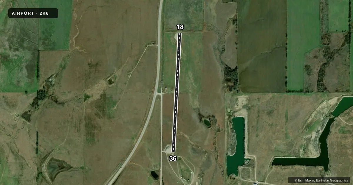
Runways & pattern
Full pagePattern entry · RWY 18
LEFT TRAFFICRunway end performance
| End | TORA | TODA | ASDA | LDA | VGSI | Approach lights | Obstruction |
|---|---|---|---|---|---|---|---|
| 36 | — | — | — | — | — | — | 38', pole, 289' from thr, 119' R of cntrln, slope 2 |
Declared distances in feet. TORA = takeoff run available, TODA = takeoff distance, ASDA = accelerate-stop, LDA = landing distance.
Airport sketch
Runways drawn to scale from FAA survey coordinates, rendered over satellite imagery. Not for navigation.
Approaches & charts
Services on the field
Fuel grades, oxygen, maintenance, ramp storage and lighting — as declared to the FAA by the airport operator.
Fuel & services
- Fuel
- Not available
- Oxygen (bottled)
- Not available
- Oxygen (bulk)
- Not available
- Airframe repair
- Not available
- Power plant repair
- Not available
Ramp & ground
- Transient storage
- Not published
- Landing fee
- No fee published
- Wind indicator
- Yes
- Segmented circle
- No
Fuel & FBOs
Cheapest 100LL and Jet A on the field and nearby. Always confirm with the FBO before taxi.
Airport notes
Surface conditions, obstructions, local procedures, lighting outages and other notes published with each FAA cycle.
General notes
- WILDLIFE ON & INVOF ARPT.
- FOR CD CTC KANSAS CITY ARTCC AT 913-254-8508.
Runway surface & condition
- 18/36RWY 18/36 HAS CENTERLINE MARKING ONLY
Approach & departure obstructions
- 18OVERGROWN GRASS WATERWAY 20 FT FM RY END. SMALL TREE 25 FT TALL, 115 FT RIGHT OF RWY.
- 36+15 FT ROAD AT THLD.
- 36THE POLES THAT CONSTITUTE THE CONTROLLING OBSTRUCTION ON THE RIGHT ARE NOT VISIBLY MARKED OR LGTD.
VFR map & nearby airports
VFR sectional. Tap any ICAO chip to open that airport.
Key facts · 2K6
Answer card- ICAO
- 2K6
- Name
- ELK COUNTY
- Location
- MOLINE, KANSAS
- Elevation
- 1,063 ft MSL
- Traffic pattern altitude
- 2,063 ft MSL (1,000 AGL)
- Control tower
- Non-towered (use CTAF)
- Total runways
- 1
- Longest runway
- 18/36 · 2,510 ft
- Published ILS approaches
- 0
- Published frequencies
- 1
- Magnetic variation
- 6°
- Current flight rules
- VFR
- Current wind
- 200° at 13 kt
- Favored runway now
- RWY 18
ELK COUNTY is in Moline, Kansas. The field elevation is 1,063 ft MSL. It has one runway, 18/36, which is 2,510 ft long. There is no control tower. CTAF is 122.9. No ILS approaches are published here.
Pattern altitude is not published. Use the standard 1,000 ft AGL pattern unless the current Chart Supplement says otherwise. That puts the traffic pattern at about 2,063 ft MSL based on the listed field elevation. The runway has centerline marking only. That matters on a short field when you are trying to stay aligned in a crosswind.
Published remarks call out several obstructions. Near runway 18 there is an overgrown grass waterway close to the end of the runway. A small tree is also reported right of the runway. Near runway 36 there is a road at the threshold. The controlling poles on the right are not visibly marked or lighted. Wildlife is also present on and near the airport. Clearance delivery is handled through Kansas City ARTCC at 913-254-8508. No on-field FBOs are listed, so verify fuel and services with the airport operator or call the field directly before you go.