METAR & TAF 07S
07S does not publish a METAR.
Showing the nearest reporting station: KEQA (EL DORADO/CAPT JACK THOMAS MEML) · 15.4 NM away. Conditions at 07S may differ.
METAR · KEQA
Observed 18:15Z
KEQA 121815Z AUTO 11007KT 10SM CLR 30/12 A3003 RMK AO2
- Wind
- 110° @ 7 kt
- Visibility
- 10 SM
- Temp / Dew
- 30°C / 12°C
- Altimeter
- 30.03 inHg
- Clouds
- CLR
- Density alt
- 3,669 ft
- Ceiling
- Unlimited
- Rules
- VFR
Airport info & contacts
Manager on record, flight service, ARTCC, attendance schedule and pattern altitude — published by the FAA and refreshed every 28 days.
Location
- From city
- 0 NM E
- VFR sectional
- KANSAS CITY
- ARTCC
- ZKC · KANSAS CITY
- NOTAM facility
- ICT (NOTAM-D)
Airport manager
- Name
- JEANNE SQUIER
- Phone
- 620-843-2422
- Address
- BEAUMONT HOTEL, 11651 SE MAIN, BEAUMONT KS 67012
Flight service · Hours
- FSS ICT
- WICHITA1-800-WX-BRIEF
- Attendance
- Unattended
Frequencies
Tap any row to copy the frequency to your clipboard.
Runways & pattern
Full pagePattern entry · RWY 18
LEFT TRAFFICRunway end performance
| End | TORA | TODA | ASDA | LDA | VGSI | Approach lights | Obstruction |
|---|---|---|---|---|---|---|---|
| 18 | — | — | — | — | — | — | 4', hill, 0' from thr, 67' R of cntrln, slope 0 |
| 36 | — | — | — | — | — | — | 15', road, 132' from thr, 135' R of cntrln, slope 8 |
Declared distances in feet. TORA = takeoff run available, TODA = takeoff distance, ASDA = accelerate-stop, LDA = landing distance.
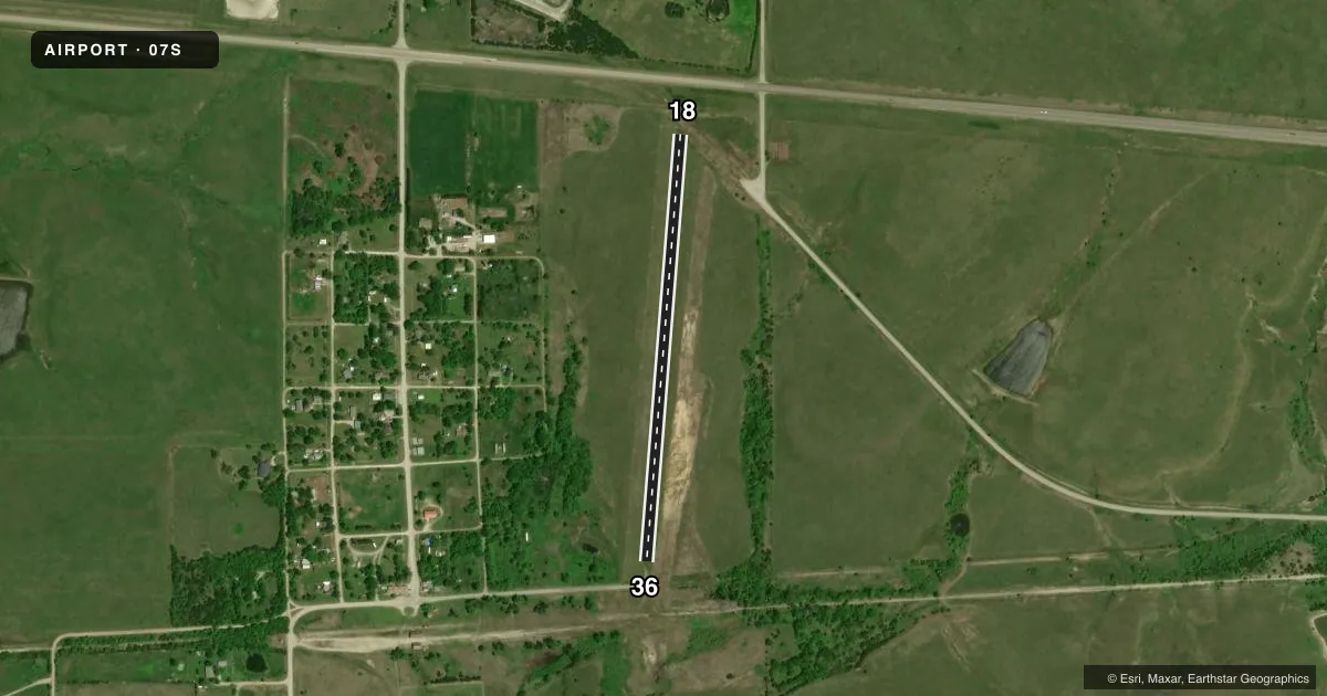
Airport sketch
Runways drawn to scale from FAA survey coordinates, rendered over satellite imagery. Not for navigation.
Approaches & charts
Services on the field
Fuel grades, oxygen, maintenance, ramp storage and lighting — as declared to the FAA by the airport operator.
Fuel & services
- Fuel
- Not available
- Oxygen (bottled)
- Not available
- Oxygen (bulk)
- Not available
- Airframe repair
- Not available
- Power plant repair
- Not available
Ramp & ground
- Transient storage
- Tie-down
- Landing fee
- No fee published
- Wind indicator
- Yes
- Segmented circle
- No
Fuel & FBOs
Cheapest 100LL and Jet A on the field and nearby. Always confirm with the FBO before taxi.
Airport notes
Surface conditions, obstructions, local procedures, lighting outages and other notes published with each FAA cycle.
General notes
- NO LINE OF SIGHT BETWEEN RWY ENDS.
- WIND TURBINE FARM AND 420 FT TWR 3 MILES SSW.
- RWY 18, 4 FT BARB WIRE FENCE 260 FT DSTC..
- OCCASIONAL LARGE ROUND HAY BALES BOTH SIDES OF RUNWAY.
- 20 FT X 1200 FT PAVED TWY TO ACFT PRKG AT HOTEL/RESTAURANT
- FOR CD CTC KANSAS CITY ARTCC AT 913-254-8508.
- AFT HRS OR EMERG CALL 316-377-3085.
- 365 FT TWR 0.7 NM WSW OF ARPT.
Approach & departure obstructions
- 18RY 18/36 MKD WITH YELLOW CONES.
- 18ALSO 6 FT FENCE, 88 FT DSTC, & 15 HWY, 248 FT DSTC ACRS APCH.
- 36ALSO 41 FT TREES, 400 FT DSTC, 60 & 180 FT L OF RCL.
Other notes
- MAINTAIN RUNWAY APPROACH FOR A MINIMUM 20:1 SLOPE AND TRANSITIONAL SURFACE FOR A 7:1 SLOPE.
VFR map & nearby airports
VFR sectional. Tap any ICAO chip to open that airport.
Key facts · 07S
Answer card- ICAO
- 07S
- Name
- BEAUMONT HOTEL
- Location
- BEAUMONT, KANSAS
- Elevation
- 1,617 ft MSL
- Traffic pattern altitude
- 2,617 ft MSL (1,000 AGL)
- Control tower
- Non-towered (use CTAF)
- Total runways
- 1
- Longest runway
- 18/36 · 2,400 ft
- Published ILS approaches
- 0
- Published frequencies
- 1
- Magnetic variation
- 6°
- Current flight rules
- VFR
- Current wind
- 110° at 7 kt
- Favored runway now
- RWY 18
Beaumont Hotel Airport (07S) sits in Beaumont, Kansas. Field elevation is 1,617 ft MSL. The airport has one runway. Runway 18/36 is 2,400 ft of turf, so plan for soft-field performance and a careful look at runway condition before you go. This is an untowered field. CTAF is 122.9.
No ILS approaches are published here. Pattern altitude is not published, so use the standard 1,000 ft AGL for light piston aircraft unless the current Chart Supplement says otherwise. That puts the pattern at 2,617 ft MSL based on the listed field elevation. The runway ends are not in line of sight with each other. That matters for spacing and self-announce discipline.
The published remarks show several things a first-time pilot should know. There are yellow cones marking runways 18 and 36. There is also a 20 ft by 1,200 ft paved taxiway to aircraft parking at the hotel and restaurant. Obstacles are close enough to matter. Runway 18 has a fence and highway in the approach area. Runway 36 has trees left of centerline. There is also a wind turbine farm and tall towers nearby. For clearance delivery, contact Kansas City ARTCC. If you need help after hours or in an emergency, use the listed phone number in the Chart Supplement.