METAR & TAF 1K1
1K1 does not publish a METAR.
Showing the nearest reporting station: KAAO (COLONEL JAMES JABARA) · 5.4 NM away. Conditions at 1K1 may differ.
METAR · KAAO
Observed 15:54Z
KAAO 271554Z AUTO 21010KT 10SM CLR 33/20 A2987 RMK AO2 SLP096 T03330200
- Wind
- 210° @ 10 kt
- Visibility
- 10 SM
- Temp / Dew
- 33°C / 20°C
- Altimeter
- 29.87 inHg
- Clouds
- CLR
- Density alt
- 3,914 ft
- Ceiling
- Unlimited
- Rules
- VFR
Airport info & contacts
Manager on record, flight service, ARTCC, attendance schedule and pattern altitude — published by the FAA and refreshed every 28 days.
Location
- From city
- 1 NM SW
- VFR sectional
- WICHITA
- ARTCC
- ZKC · KANSAS CITY
- NOTAM facility
- ICT (NOTAM-D)
Airport manager
- Name
- DWAYNE CLEMENS
- Phone
- 316-648-0132
- Address
- 14789 SOUTHWEST 30TH. STREET, BENTON KS 67017
Flight service · Hours
- FSS ICT
- WICHITA1-800-WX-BRIEF
- Attendance
- UNATND
Frequencies
Tap any row to copy the frequency to your clipboard.
Runways & pattern
Full pagePattern entry · RWY 17
RIGHT TRAFFICRunway end performance
| End | TORA | TODA | ASDA | LDA | VGSI | Approach lights | Obstruction |
|---|---|---|---|---|---|---|---|
| 17 | — | — | — | — | — | — | 47', trees, 530' from thr, 240' R of cntrln, slope 7 |
| 35 | — | — | — | — | — | — | 24', hangar, 0' from thr, 218' R of cntrln, slope 0 |
Declared distances in feet. TORA = takeoff run available, TODA = takeoff distance, ASDA = accelerate-stop, LDA = landing distance.
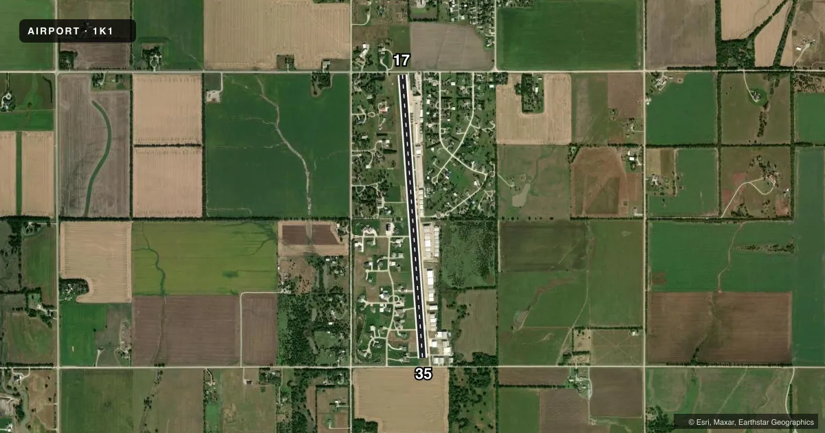
Airport sketch
Runways drawn to scale from FAA survey coordinates, rendered over satellite imagery. Not for navigation.
Approaches & charts
Services on the field
Fuel grades, oxygen, maintenance, ramp storage and lighting — as declared to the FAA by the airport operator.
Fuel & services
- Fuel
- 100LLA+
Ramp & ground
- Transient storage
- Tie-down
- Hangar
- Landing fee
- No fee published
- Lighting schedule
- SS-SR
- Beacon schedule
- SS-SR
- Beacon
- White / Green (civil land)(WG)
- Wind indicator
- Lighted
- Segmented circle
- No
Fuel & FBOs
Cheapest 100LL and Jet A on the field and nearby. Always confirm with the FBO before taxi.
Airport notes
Surface conditions, obstructions, local procedures, lighting outages and other notes published with each FAA cycle.
General notes
- UNCTLD VEHICLE TFC INVOF HANGARS & ON TWYS. BACK TAX ON RWY WHEN ABLE.
- ULTRALIGHT ACFT PPR.
- TWIN & LRGR BACK TAXI ON RWY.
- 70 FT WIDE CONC TWY TURN OFF MIDFIELD.
- FOR CD CTC WICHITA APCH AT 316-350-1520.
Fuel notes
- 100LL100 LL 24 HR SELF SERVE. JET A+ REQ 24 HRS IN ADV.
Approach & departure obstructions
- 1717 FT RD 38 FT DSTC, 125 FT L/R; 31 FT TREE, 1 FT DSTC, 190 FT R.
- 3524 FT HGR, 0-199 FT DSTC, 218 FT R; 23 FT WINDSOCK, 132 FT DSTC, 118 FT R.
- 17OBSTN CLNC SLOPE 0:1 TO DTHR OVR 25 FT BLDG, 0 FT DSTC, 200 FT L.
- 35OBSTN CLNC SLOPE 0:1 TO DTHR OVR 25 FT BLDG, 0 FT DSTC, 200 FT L.
VFR map & nearby airports
VFR sectional. Tap any ICAO chip to open that airport.
Key facts · 1K1
Answer card- ICAO
- 1K1
- Name
- LLOYD STEARMAN FLD
- Location
- BENTON, KANSAS
- Elevation
- 1,364.3 ft MSL
- Traffic pattern altitude
- 2,364.3 ft MSL (1,000 AGL)
- Control tower
- Non-towered (use CTAF)
- Total runways
- 1
- Longest runway
- 17/35 · 5,105 ft
- Published ILS approaches
- 0
- Published frequencies
- 5
- Magnetic variation
- 4°
- Current flight rules
- VFR
- Current wind
- 210° at 10 kt
- Favored runway now
- RWY 17
Lloyd Stearman Fld sits in Benton, Kansas. The field elevation is 1,364.1 ft MSL. It has one runway. Runway 17/35 is 5,106 ft of asphalt. There is no control tower. No ILS approaches are published. The published pattern altitude is not listed, so use the standard 1,000 ft AGL for light piston operations unless the current Chart Supplement says otherwise.
Stearman Field is the on-field FBO. It carries 100LL. 24-hour self-serve 100LL is available. Jet A plus needs 24 hours advance notice. The airport sits under Wichita Approach for clearance delivery. Contact them at 316-350-1520 if you need to sort out IFR paperwork before departure.
A first-time pilot should pay attention to the published obstruction notes. There are hangars, a windsock, a building, a road and a tree close to the runway environment. The remarks also call out uncontrolled vehicle traffic near hangars and on taxiways. Back taxi on the runway when able. Twin and larger aircraft are expected to back taxi. Ultralights need prior permission. If you are planning a night or IFR arrival, check the current Chart Supplement and brief the runway environment carefully before you launch.