METAR & TAF KAAO
Current METAR
Observed 03:26Z
KAAO 240326Z AUTO 12003KT 2SM BR FEW004 20/20 A3009 RMK AO2 T02000200 PNO $
- Wind
- 120° @ 3 kt
- Visibility
- 2 SM
- Temp / Dew
- 20°C / 20°C
- Altimeter
- 30.09 inHg
- Clouds
- FEW
- Density alt
- 2,151 ft
- Ceiling
- Unlimited
- Rules
- IFR
Airport info & contacts
Manager on record, flight service, ARTCC, attendance schedule and pattern altitude — published by the FAA and refreshed every 28 days.
Location
- From city
- 9 NM NE
- VFR sectional
- WICHITA
- ARTCC
- ZKC · KANSAS CITY
- NOTAM facility
- AAO (NOTAM-D)
Airport manager
- Name
- MR. JESSE ROMO
- Phone
- 316-946-4700
- Address
- 2173 AIR CARGO ROAD, WICHITA KS 67209
Flight service · Hours
- FSS ICT
- WICHITA1-800-WX-BRIEF
- Attendance
- ALL
Frequencies
Tap any row to copy the frequency to your clipboard.
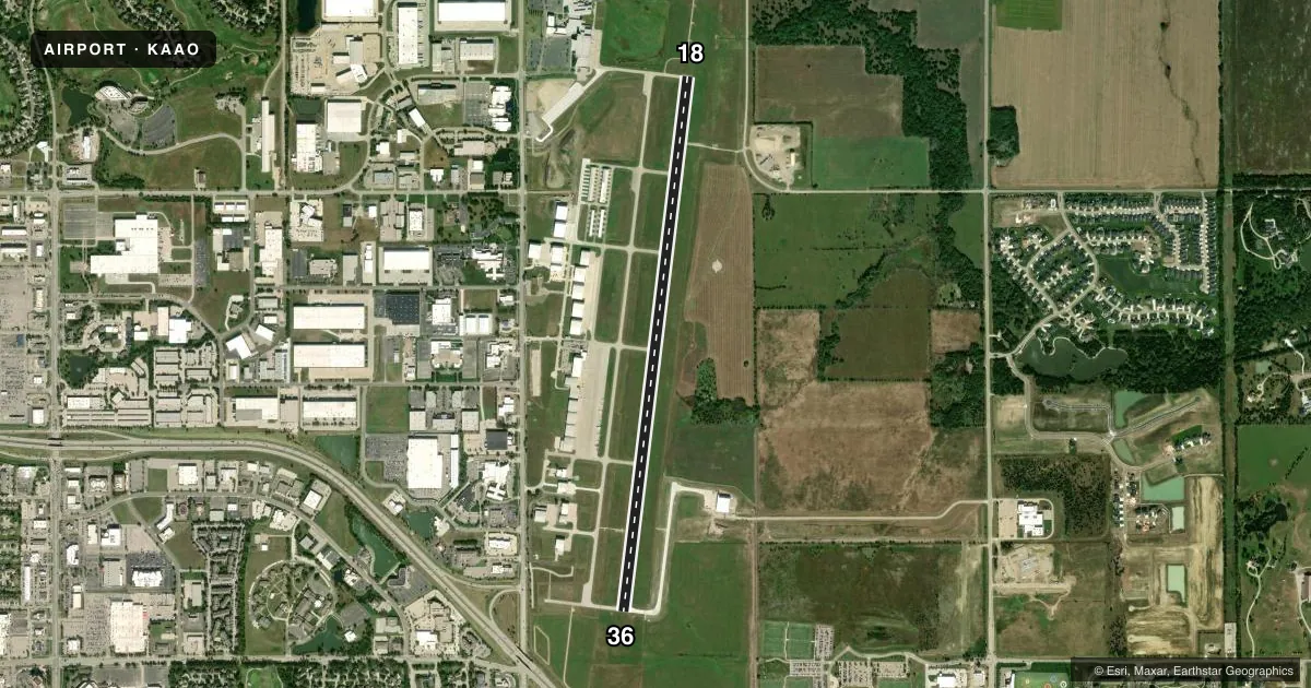
Runways & pattern
Full pagePattern entry · RWY 18
RIGHT TRAFFICRunway end performance
| End | TORA | TODA | ASDA | LDA | VGSI | Approach lights | Obstruction |
|---|---|---|---|---|---|---|---|
| 18 | — | — | — | — | PAPI 4-box left(3°) | MALSR | — |
| 36 | — | — | — | — | PAPI 4-box left(3°) | — | — |
Declared distances in feet. TORA = takeoff run available, TODA = takeoff distance, ASDA = accelerate-stop, LDA = landing distance.
Airport sketch
Runways drawn to scale from FAA survey coordinates, rendered over satellite imagery. Not for navigation.
Approaches & charts
ILS · 1
Services on the field
Fuel grades, oxygen, maintenance, ramp storage and lighting — as declared to the FAA by the airport operator.
Fuel & services
- Fuel
- 100LLA
- Oxygen (bottled)
- Not available
- Oxygen (bulk)
- Not available
- Airframe repair
- Major
- Power plant repair
- Major
- Other services
- AMB,CHTR,INSTR,SALES
Ramp & ground
- Transient storage
- Tie-down
- Hangar
- Landing fee
- No fee published
- Customs
- Not available
- Lighting schedule
- SEE RMK
- Beacon schedule
- SS-SR
- Beacon
- White / Green (civil land)(WG)
- Wind indicator
- Lighted
- Segmented circle
- Yes
Fuel & FBOs
Cheapest 100LL and Jet A on the field and nearby. Always confirm with the FBO before taxi.
Airport notes
Surface conditions, obstructions, local procedures, lighting outages and other notes published with each FAA cycle.
General notes
- ATTENDED CONTINUOUSLY.
- MCCONNELL AFB 9 MILES S AND BEECH FACTORY ARPT 3 MILES S.
- BEECH FACTORY ARPT CLASS D AIRSPACE 1 MILE S RWY 18.
- SOUTHERLY AND SOUTHEASTERLY VFR ARR AND DEP NOT RECOMMENDED WITHOUT ATC RADAR SVCS DUE TO BEECH FACTORY ARPT AND MCCONNELL AFB CLASS D AIRSPACE.
- VFR ARR AND DEP RECOMMENDED TO RMN AT OR BLW 2,500 MSL WITHIN 5 MILES DUE TO HEAVY MIL TFC 3,000 MSL.
- NO LINE OF SIGHT BETWEEN RWY ENDS.
- RWY 36 DSGND CALM WIND RWY.
- ENGINE RUN-UPS NOT PERMITTED ON ACFT RAMPS.
- PPR FOR ACFT CARRYING CLASS 1 DIVISION 1.1, 1.2 OR 1.3 EXPLOSIVES AS DEFINED BY 49 CFR 173.50.
- BIRDS ON AND IN VCNTY OF ARPT.
- MIGRATORY BIRDS ON AND INVOF OF ARPT.
Lighting notes
- ACTVT MIRL RWY 18/36, MALSR RWY 18, REIL RWY 36 - CTAF.
Fuel notes
- 100LLFOR 24 HOUR FUEL CONTACT FBO 316-636-9700
Other notes
- RWY 18/36 HAS NO OBJECTION.
VFR map & nearby airports
VFR sectional. Tap any ICAO chip to open that airport.
Key facts · KAAO
Answer card- ICAO
- KAAO
- Name
- COLONEL JAMES JABARA
- Location
- WICHITA, KANSAS
- Elevation
- 1,420.8 ft MSL
- Traffic pattern altitude
- 2,420.8 ft MSL (1,000 AGL)
- Control tower
- Non-towered (use CTAF)
- Total runways
- 1
- Longest runway
- 18/36 · 6,101 ft
- Published ILS approaches
- 1
- Published frequencies
- 5
- Magnetic variation
- 6°
- Current flight rules
- IFR
- Current wind
- 120° at 3 kt
- Favored runway now
- RWY 18
Colonel James Jabara Airport (KAAO) is in Wichita, Kansas. The field elevation is 1,420.8 ft MSL. It has one runway, 18/36, which is 6,101 ft long and paved with concrete. There is no control tower. CTAF and UNICOM are both 122.7. The airport is attended continuously.
One ILS approach is published for runway 18. Runway lighting is medium intensity on 18/36. The approach lighting system with runway alignment indicator lights is on runway 18. Runway end identifier lights are on runway 36. The published pattern altitude is not listed, so use the standard 1,000 ft AGL for light piston traffic unless current instructions say otherwise. That works out to about 2,421 ft MSL at this field.
Clemens Aviation is on the field. It carries 100LL and Jet A Prist. For 24-hour fuel, contact the FBO at (316) 636-9700. A few operational items matter here. Engine run-ups are not permitted on the ramps. Birds are reported on and near the airport. VFR arrivals and departures are recommended to stay at or below 2,500 ft MSL within 5 miles because of heavy military traffic at 3,000 ft MSL. McConnell Air Force Base is 9 miles south. Beech Factory Airport is 3 miles south. Beech Factory Airport Class D airspace is 1 mile south of runway 18.