METAR & TAF KCEA
KCEA does not publish a METAR.
Showing the nearest reporting station: KBEC (BEECH FACTORY) · 3.2 NM away. Conditions at KCEA may differ.
METAR · KBEC
Observed 17:15Z
KBEC 271715Z AUTO 20011G14KT 10SM CLR 35/20 A2987 RMK AO2 T03520198
- Wind
- 200° @ 11G14 kt
- Visibility
- 10 SM
- Temp / Dew
- 35°C / 20°C
- Altimeter
- 29.87 inHg
- Clouds
- CLR
- Density alt
- 4,171 ft
- Ceiling
- Unlimited
- Rules
- VFR
Airport info & contacts
Manager on record, flight service, ARTCC, attendance schedule and pattern altitude — published by the FAA and refreshed every 28 days.
Location
- From city
- 4 NM SE
- VFR sectional
- WICHITA
- ARTCC
- ZKC · KANSAS CITY
- NOTAM facility
- ICT (NOTAM-D)
Airport manager
- Name
- TODD BAYLESS
- Phone
- 316-515-8365
- Address
- 10511 EAST CENTRAL, WICHITA KS 67201
Flight service · Hours
- FSS ICT
- WICHITA1-800-WX-BRIEF
- Attendance
- Unattended
Frequencies
Tap any row to copy the frequency to your clipboard.
Runways & pattern
Full pagePattern entry · RWY 17
LEFT TRAFFICRunway end performance
| End | TORA | TODA | ASDA | LDA | VGSI | Approach lights | Obstruction |
|---|---|---|---|---|---|---|---|
| 17 | — | — | — | — | — | — | 10', road, 252' from thr, 0' R of cntrln, slope 5 |
| 35 | — | — | — | — | — | — | 13', road, 210' from thr, 0' R of cntrln, slope 0 |
Declared distances in feet. TORA = takeoff run available, TODA = takeoff distance, ASDA = accelerate-stop, LDA = landing distance.
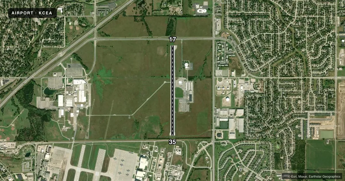
Airport sketch
Runways drawn to scale from FAA survey coordinates, rendered over satellite imagery. Not for navigation.
Approaches & charts
Services on the field
Fuel grades, oxygen, maintenance, ramp storage and lighting — as declared to the FAA by the airport operator.
Fuel & services
- Fuel
- Not available
- Oxygen (bottled)
- Not available
- Oxygen (bulk)
- Not available
- Airframe repair
- Not available
- Power plant repair
- Not available
Ramp & ground
- Transient storage
- Not published
- Landing fee
- No fee published
- Wind indicator
- Yes
- Segmented circle
- Yes
Fuel & FBOs
Cheapest 100LL and Jet A on the field and nearby. Always confirm with the FBO before taxi.
Airport notes
Surface conditions, obstructions, local procedures, lighting outages and other notes published with each FAA cycle.
General notes
- ACFT OPNS SHOULD COORDINATE WITH MC CONNELL AFB PRIOR TO ARRIVAL AND DEP - CONTROL TOWER 127.25.
- RWY 17R/35L USED ONLY BY CESSNA PERSONNEL; CLOSED TO PUBLIC.
- FOR CD CTC WICHITA APCH AT 316-350-1520.
Approach & departure obstructions
- 358 FT FENCE 170 FT FM RWY END.
- 17OBSTN CLNC SLP 20:1 TO DTHR OVR 23 FT TREE, 475 FT DSTC, 50 FT R.
- 35OBSTN CLNC SLP 27:1 TO DTHR.
Other notes
- THIS AIRPORT HAS BEEN SURVEYED BY THE NATIONAL GEODETIC SURVEY.
- EXISTED PRIOR TO 1959.
VFR map & nearby airports
VFR sectional. Tap any ICAO chip to open that airport.
Key facts · KCEA
Answer card- ICAO
- KCEA
- Name
- CESSNA ACFT FLD
- Location
- WICHITA, KANSAS
- Elevation
- 1,378 ft MSL
- Traffic pattern altitude
- 2,378 ft MSL (1,000 AGL)
- Control tower
- Non-towered (use CTAF)
- Total runways
- 1
- Longest runway
- 17/35 · 3,873 ft
- Published ILS approaches
- 0
- Published frequencies
- 4
- Magnetic variation
- 8°
- Current flight rules
- VFR
- Current wind
- 200° at 11 kt
- Favored runway now
- RWY 17
Cessna Acft Fld sits in Wichita, Kansas. Field elevation is 1,378 ft MSL. The airport has one runway for public use. Runway 17/35 is 3,873 ft long with asphalt pavement. The published pattern altitude is not listed. Use the standard 1,000 ft AGL pattern unless local procedures or ATC say otherwise.
This is not a towered airport. CTAF is 122.9. Wichita Approach handles approach and departure work on 134.8 and 269.1. Published remarks also say to contact Wichita Approach at 316-350-1520 for clearance delivery. Aircraft operations should coordinate with McConnell Air Force Base before arrival and departure. That matters here. Treat this as a controlled local environment even without a control tower.
No ILS approaches are published. The field has no on-field FBOs listed, so plan ahead for services and verify current support with the airport operator before you go. Runway 17 has a tree near the approach path. Runway 35 has a fence near the end. There is also a published obstacle clearance slope to the displaced threshold. The airport sits in a busy Wichita area. Expect to stay sharp on routing, coordination and runway planning.