METAR & TAF KICT
Current METAR
Observed 15:53Z
KICT 271553Z 20011KT 10SM FEW200 34/19 A2986 RMK AO2 SLP092 T03440194 $
- Wind
- 200° @ 11 kt
- Visibility
- 10 SM
- Temp / Dew
- 34°C / 19°C
- Altimeter
- 29.86 inHg
- Clouds
- FEW
- Density alt
- 4,007 ft
- Ceiling
- Unlimited
- Rules
- VFR
Airport info & contacts
Manager on record, flight service, ARTCC, attendance schedule and pattern altitude — published by the FAA and refreshed every 28 days.
Location
- From city
- 5 NM SW
- VFR sectional
- WICHITA
- ARTCC
- ZKC · KANSAS CITY
- NOTAM facility
- ICT (NOTAM-D)
Airport manager
- Name
- MR. JESSE ROMO, A.A.E.
- Phone
- 316-946-4700
- Address
- 2173 AIR CARGO ROAD, WICHITA KS 67209
Flight service · Hours
- FSS ICT
- WICHITA1-800-WX-BRIEF
- Attendance
- ALL
Frequencies
Tap any row to copy the frequency to your clipboard.
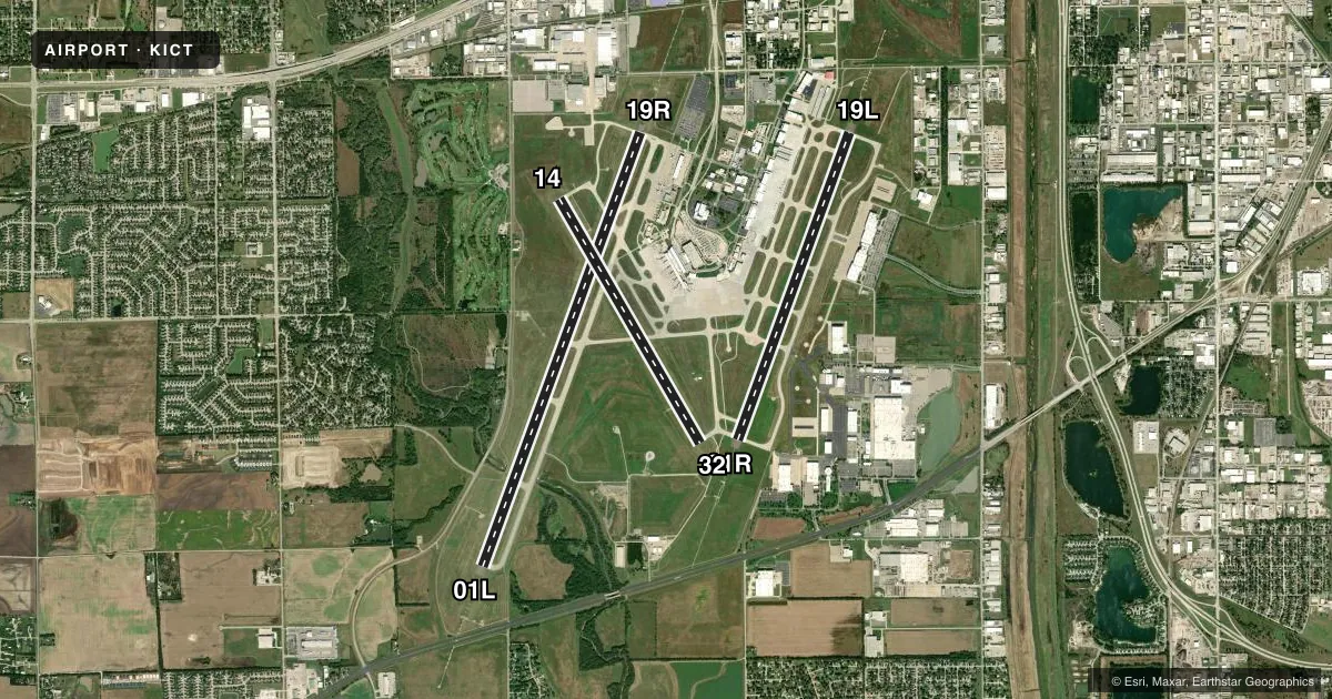
Runways & pattern
Full pagePattern entry · RWY 19R
RIGHT TRAFFIC| Runway | Heading (°M) | Length | Surface | Traffic |
|---|---|---|---|---|
| 01L/19RFavored | 16° / 196° | 10,302 ft | CONC | 19R R |
| 01R/19L | 16° / 196° | 7,302 ft | CONC | 01R R |
| 14/32 | 146° / 326° | 6,301 ft | CONC | Standard L |
Runway end performance
| End | TORA | TODA | ASDA | LDA | VGSI | Approach lights | Obstruction |
|---|---|---|---|---|---|---|---|
| 01L | 10,301' | 10,301' | 10,301' | 10,301' | — | ALSF2 | — |
| 19R | 10,301' | 10,301' | 10,301' | 10,301' | — | MALSR | — |
| 01R | 7,302' | 7,302' | 7,302' | 7,302' | — | MALSR | — |
| 19L | 7,302' | 7,302' | 7,302' | 7,302' | PAPI 4-box left(3°) | MALSR | — |
| 14 | 6,301' | 6,301' | 6,301' | 6,301' | PAPI 4-box left(3°) | — | — |
| 32 | 6,301' | 6,301' | 6,301' | 6,301' | PAPI 4-box left(3°) | — | — |
Declared distances in feet. TORA = takeoff run available, TODA = takeoff distance, ASDA = accelerate-stop, LDA = landing distance.
Airport sketch
Runways drawn to scale from FAA survey coordinates, rendered over satellite imagery. Not for navigation.
Approaches & charts
ILS · 4
Services on the field
Fuel grades, oxygen, maintenance, ramp storage and lighting — as declared to the FAA by the airport operator.
Fuel & services
- Fuel
- 100LLA
- Oxygen (bottled)
- HIGH/LOW
- Oxygen (bulk)
- HIGH/LOW
- Airframe repair
- Major
- Power plant repair
- Major
- Other services
- AFRT,AMB,AVNCS,CARGO,CHTR,INSTR,RNTL,SALES
Ramp & ground
- Transient storage
- Tie-down
- Hangar
- Landing fee
- No fee published
- Customs
- Not available
- Beacon schedule
- SS-SR
- Beacon
- White / Green (civil land)(WG)
- Wind indicator
- Lighted
- Segmented circle
- No
Fuel & FBOs
Cheapest 100LL and Jet A on the field and nearby. Always confirm with the FBO before taxi.
Airport notes
Surface conditions, obstructions, local procedures, lighting outages and other notes published with each FAA cycle.
General notes
- ATTENDED CONTINUOUSLY.
- ATCT HAS LTD VIS OF TRML GATES 1 THRU 8, TWY H, AND CUSTOMS PRKG RAMP.
- CALL FOR GATE PUSHBACK NOT REQUIRED.
- TWYS F, G, H, J, P AND ALL ACFT PARKING RAMPS ARE NONMOVEMENT AREAS.
- TWY H CLSD TO ACFT WITH WINGSPAN MORE THAN 79.
- TWY L AND L1 CLSD TO ACFT WITH WINGSPAN MORE THAN 118.
- TWY P CLSD TO ACFT WITH WINGSPAN MORE THAN 79.
- AIR CARGO RAMP CLSD TO ACFT WINGSPAN MORE THAN 148 FT.
- ACFT PARKING BAS CONTACT 132.00 FOR PARKING INSTRUCTIONS PRIOR TO EXITING TWY L1.
- FLIGHT NOTIFICATION SERVICE (ADCUS) AVBL.
- AIRCRAFT ENGINE RUNS ABOVE IDLE NOT APPROVED ON AIRCRAFT PARKING RAMPS.
- PPR REQUIRED FOR ACFT CARRYING CLASS 1DIVISION 1.1, 1.2 OR 1.3 EXPLOSIVES AS DEFINED BY 49 CFR 173.50 OR AS AMENDED.
- MIGRATORY BIRDS ON AND IN VICINITY OF ARPT, ALL QUADS.
Runway surface & condition
- 01L/19RPCR VALUE: 700/R/B/W/T
- 01R/19LPCR VALUE: 707/R/A/W/T
- 14/32PCR VALUE: 734/R/C/W/T
VFR map & nearby airports
VFR sectional. Tap any ICAO chip to open that airport.
Key facts · KICT
Answer card- ICAO
- KICT
- Name
- WICHITA DWIGHT D EISENHOWER NTL
- Location
- WICHITA, KANSAS
- Elevation
- 1,332.6 ft MSL
- Traffic pattern altitude
- 2,332.6 ft MSL (1,000 AGL)
- Control tower
- Towered · 24
- Total runways
- 3
- Longest runway
- 01L/19R · 10,302 ft
- Published ILS approaches
- 4
- Published frequencies
- 22
- Magnetic variation
- 4°
- Current flight rules
- VFR
- Current wind
- 200° at 11 kt
- Favored runway now
- RWY 19R
KICT is in Wichita, Kansas. The field elevation is 1,332.6 ft MSL. It has three concrete runways. The longest is 01L/19R at 10,302 ft. The airport is towered 24 hours a day. There are four ILS approaches available to runway ends 01L, 01R, 19L and 19R.
The published pattern altitude is not listed in the facts. Use the current FAA Chart Supplement before you fly. For light piston traffic, the standard 1,000 ft AGL pattern is often used when no local value is published, which would put you near 2,333 ft MSL here. Verify that with the current FAA Chart Supplement or the tower. Wichita is a busy controlled field. Expect close attention to taxi instructions and ramp limits. The tower has limited visibility of terminal gates 1 through 8, taxiway H and the customs parking ramp. Taxiways F, G, H, J, P, plus all aircraft parking ramps, are nonmovement areas.
On field, Yingling Aviation carries 100LL and Jet A Prist. Signature Aviation carries 100LL and Jet A. Taxiway H and taxiway P are closed to aircraft with wingspans over 79 ft. The air cargo ramp is closed to aircraft with wingspans over 148 ft. Parking instructions use base contact frequency 132.00 before exiting taxiway L1. The airport is attended continuously.