METAR & TAF 72K
72K does not publish a METAR.
Showing the nearest reporting station: KICT (WICHITA DWIGHT D EISENHOWER NTL) · 4.5 NM away. Conditions at 72K may differ.
METAR · KICT
Observed 16:53Z
KICT 271653Z 19012KT 10SM FEW200 36/19 A2986 RMK AO2 SLP091 T03610189
- Wind
- 190° @ 12 kt
- Visibility
- 10 SM
- Temp / Dew
- 36°C / 19°C
- Altimeter
- 29.86 inHg
- Clouds
- FEW
- Density alt
- 4,172 ft
- Ceiling
- Unlimited
- Rules
- VFR
Airport info & contacts
Manager on record, flight service, ARTCC, attendance schedule and pattern altitude — published by the FAA and refreshed every 28 days.
Location
- From city
- 5 NM SW
- VFR sectional
- WICHITA
- ARTCC
- ZKC · KANSAS CITY
- NOTAM facility
- ICT (NOTAM-D)
Airport manager
- Name
- EARL LONG
- Phone
- 316-943-5510
- Address
- 1801 W 47 ST S, WICHITA KS 67217
Flight service · Hours
- FSS ICT
- WICHITA1-800-WX-BRIEF
- Attendance
- Unattended
Frequencies
Tap any row to copy the frequency to your clipboard.
Runways & pattern
Full pagePattern entry · RWY 17
LEFT TRAFFICRunway end performance
| End | TORA | TODA | ASDA | LDA | VGSI | Approach lights | Obstruction |
|---|---|---|---|---|---|---|---|
| 17 | — | — | — | — | — | — | 60', pline, 40' from thr, 0' R of cntrln, slope 0 |
| 35 | — | — | — | — | — | — | 50', trees, 0' from thr, 52' R of cntrln, slope 0 |
Declared distances in feet. TORA = takeoff run available, TODA = takeoff distance, ASDA = accelerate-stop, LDA = landing distance.
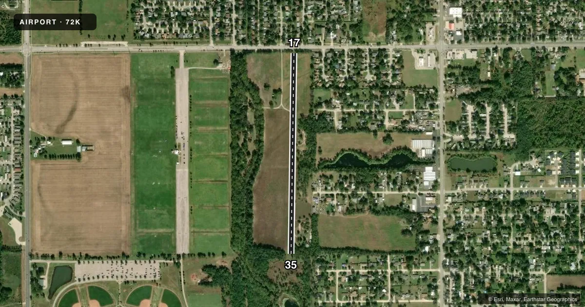
Airport sketch
Runways drawn to scale from FAA survey coordinates, rendered over satellite imagery. Not for navigation.
Approaches & charts
Services on the field
Fuel grades, oxygen, maintenance, ramp storage and lighting — as declared to the FAA by the airport operator.
Fuel & services
- Fuel
- Not available
- Oxygen (bulk)
- Not available
Ramp & ground
- Transient storage
- Hangar
- Landing fee
- No fee published
- Wind indicator
- Yes
- Segmented circle
- No
Fuel & FBOs
Cheapest 100LL and Jet A on the field and nearby. Always confirm with the FBO before taxi.
Airport notes
Surface conditions, obstructions, local procedures, lighting outages and other notes published with each FAA cycle.
General notes
- ROAD CROSSES N END RWY 17/35. 775 FT FM AER 17 LARGE RIDGE AT CROSSING.
- IF CONDS FAVORABLE BALLON TFC IN AREA.
- CROPS BOTH SIDES RWY 17/35
- EDGE DROP OFF ALONG EAST EDGE RWY 17/35
- FOR CD CTC WICHITA APCH AT 316-350-1520.
Approach & departure obstructions
- 17NUMEROUS TREES IN THE APPROACH.
- 1760 FT POWER LINE MKD WITH RED BALLS.
Other notes
- EXISTED PRIOR TO 1959.
- 17/35ROUGH & BUMPY. 10 FT DIRT RD CROSSES RWY 780 FT FM N END.
VFR map & nearby airports
VFR sectional. Tap any ICAO chip to open that airport.
Key facts · 72K
Answer card- ICAO
- 72K
- Name
- WESTPORT AUXILIARY
- Location
- WICHITA, KANSAS
- Elevation
- 1,272 ft MSL
- Traffic pattern altitude
- 2,272 ft MSL (1,000 AGL)
- Control tower
- Non-towered (use CTAF)
- Total runways
- 1
- Longest runway
- 17/35 · 2,550 ft
- Published ILS approaches
- 0
- Published frequencies
- 1
- Magnetic variation
- 7°
- Current flight rules
- VFR
- Current wind
- 190° at 12 kt
- Favored runway now
- RWY 17
Westport Auxiliary Airport is in Wichita, Kansas. Field elevation is 1,272 ft MSL. The airport has one runway, 17/35 and it is 2,550 ft long on turf. There is no control tower. CTAF is 122.9. No ILS approaches are published here.
Pattern altitude is not published. Use the standard 1,000 ft AGL pattern unless local procedures or current Chart Supplement remarks say otherwise. That puts the light piston pattern at 2,272 ft MSL based on the listed field elevation. The runway headings are 181° and 1° magnetic. The runway surface is rough and bumpy. A dirt road crosses the runway near the north end. There is also a ridge near that crossing. Trees are in the approach to runway 17. An edge drop off runs along the east side of the runway.
No on-field FBOs are listed. Check with the airport operator or the FBO directly by phone before arrival. For clearance delivery, Wichita Approach is listed in the remarks at 316-350-1520. Balloon traffic may be in the area when conditions are favorable. This is a turf strip with nearby obstructions. Plan a careful arrival and departure. Especially if you are new to the field.