METAR & TAF 3AU
Current METAR
Observed 17:15Z
K3AU 271715Z AUTO 17009KT 10SM CLR 35/19 A2987 RMK AO2
- Wind
- 170° @ 9 kt
- Visibility
- 10 SM
- Temp / Dew
- 35°C / 19°C
- Altimeter
- 29.87 inHg
- Clouds
- CLR
- Density alt
- 4,106 ft
- Ceiling
- Unlimited
- Rules
- VFR
Airport info & contacts
Manager on record, flight service, ARTCC, attendance schedule and pattern altitude — published by the FAA and refreshed every 28 days.
Location
- From city
- 5 NM W
- VFR sectional
- WICHITA
- ARTCC
- ZKC · KANSAS CITY
- NOTAM facility
- ICT (NOTAM-D)
Airport manager
- Name
- RANDY ANNETT
- Phone
- 316-733-1327
- Address
- 4800 W. BEECH DR, STE 1, PO BOX 489, AUGUSTA KS 67010
Flight service · Hours
- FSS ICT
- WICHITA1-800-WX-BRIEF
- Attendance
- MON-FRI · 0800-1700
Frequencies
Tap any row to copy the frequency to your clipboard.
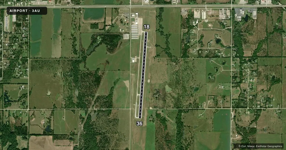
Runways & pattern
Full pagePattern entry · RWY 18
LEFT TRAFFICRunway end performance
| End | TORA | TODA | ASDA | LDA | VGSI | Approach lights | Obstruction |
|---|---|---|---|---|---|---|---|
| 18 | — | — | — | — | PAPI 4-box left(3°) | — | 58', trees, 1660' from thr, 100' R of cntrln, slope 25 |
| 36 | — | — | — | — | PAPI 4-box left(3°) | — | — |
Declared distances in feet. TORA = takeoff run available, TODA = takeoff distance, ASDA = accelerate-stop, LDA = landing distance.
Airport sketch
Runways drawn to scale from FAA survey coordinates, rendered over satellite imagery. Not for navigation.
Approaches & charts
Services on the field
Fuel grades, oxygen, maintenance, ramp storage and lighting — as declared to the FAA by the airport operator.
Fuel & services
- Fuel
- 100LLA+MOGAS
- Oxygen (bottled)
- Low pressure
- Oxygen (bulk)
- Not available
- Airframe repair
- Major
- Power plant repair
- Major
- Other services
- AVNCS,CHTR,INSTR,RNTL
Ramp & ground
- Transient storage
- Tie-down
- Hangar
- Landing fee
- No fee published
- Customs
- Not available
- Lighting schedule
- SEE RMK
- Beacon schedule
- SS-SR
- Beacon
- White / Green (civil land)(WG)
- Wind indicator
- Yes
- Segmented circle
- Yes
Fuel & FBOs
Cheapest 100LL and Jet A on the field and nearby. Always confirm with the FBO before taxi.
Airport notes
Surface conditions, obstructions, local procedures, lighting outages and other notes published with each FAA cycle.
General notes
- AFT HRS SVC 316-733-1326.
- PAEW MOWING SUMMER MONTHS.
- RWY ENDS LINE OF SITE OBSTRUCTED BY TERRAIN.
- CALM WIND RWY 18.
- LINE OFC 316-733 1326.
- FOR CD CTC WICHITA APCH AT 316-350-1520.
- 5 FT DITCH 330 N OF APCH END OF RWY 18.
Lighting notes
- ACTVT REILS RWY 18 & 36, PAPI RWY 18 & 36, MIRLS RWY 18/36 - CTAF.
Fuel notes
- 100LLSELF SVC AND FULL SVC 100LL, MOGAS, JET A+ FULL SVC.
VFR map & nearby airports
VFR sectional. Tap any ICAO chip to open that airport.
Key facts · 3AU
Answer card- ICAO
- 3AU
- Name
- AUGUSTA MUNI
- Location
- AUGUSTA, KANSAS
- Elevation
- 1,325.5 ft MSL
- Traffic pattern altitude
- 2,325.5 ft MSL (1,000 AGL)
- Control tower
- Non-towered (use CTAF)
- Total runways
- 1
- Longest runway
- 18/36 · 4,501 ft
- Published ILS approaches
- 0
- Published frequencies
- 5
- Magnetic variation
- 4°
- Current flight rules
- VFR
- Current wind
- 170° at 9 kt
- Favored runway now
- RWY 18
Augusta Muni is in Augusta, Kansas. The field elevation is 1,325.5 ft MSL. It has one runway, 18/36, which is 4,501 ft long. There is no control tower. Traffic uses CTAF 122.8 and UNICOM 122.8. The pattern altitude is not published, so light piston pilots should plan on the standard 1,000 ft AGL unless the current Chart Supplement says otherwise.
No ILS approaches are published here. The airport does have runway lighting on 18/36. The published remarks also note runway end identifier lights and PAPI on both ends. Use CTAF for airport traffic calls. Calm wind favors runway 18. The runway ends have terrain blocking line of sight. Keep a close scan on position reports and traffic calls.
The on-field FBO is Augusta Municipal Airport. It carries 100LL, Jet A and mogas. Self-service and full-service fuel are both listed in the published remarks. The line office and after-hours phone is 316-733-1326. Wichita Approach handles clearance delivery and approach or departure services. For a first visit, pay attention to the terrain near the runway ends and the 5 ft ditch 330 ft north of the approach end of runway 18. Mowing also occurs during summer months.