METAR & TAF KEGT
Current METAR
Observed 17:15Z
KEGT 271715Z AUTO 20008KT 10SM 37/19 A2987 RMK AO2 T03670193
- Wind
- 200° @ 8 kt
- Visibility
- 10 SM
- Temp / Dew
- 37°C / 19°C
- Altimeter
- 29.87 inHg
- Clouds
- Clear
- Density alt
- 4,285 ft
- Ceiling
- Unlimited
- Rules
- VFR
Airport info & contacts
Manager on record, flight service, ARTCC, attendance schedule and pattern altitude — published by the FAA and refreshed every 28 days.
Location
- From city
- 3 NM N
- VFR sectional
- WICHITA
- ARTCC
- ZKC · KANSAS CITY
- NOTAM facility
- ICT (NOTAM-D)
Airport manager
- Name
- MATTHEW D. WIEBE
- Phone
- 620-440-2213
- Address
- 441 NORTH WEST ROAD, WELLINGTON KS 67152
Flight service · Hours
- FSS ICT
- WICHITA1-800-WX-BRIEF
- Attendance
- MON-FRI · 0800-1700
Frequencies
Tap any row to copy the frequency to your clipboard.
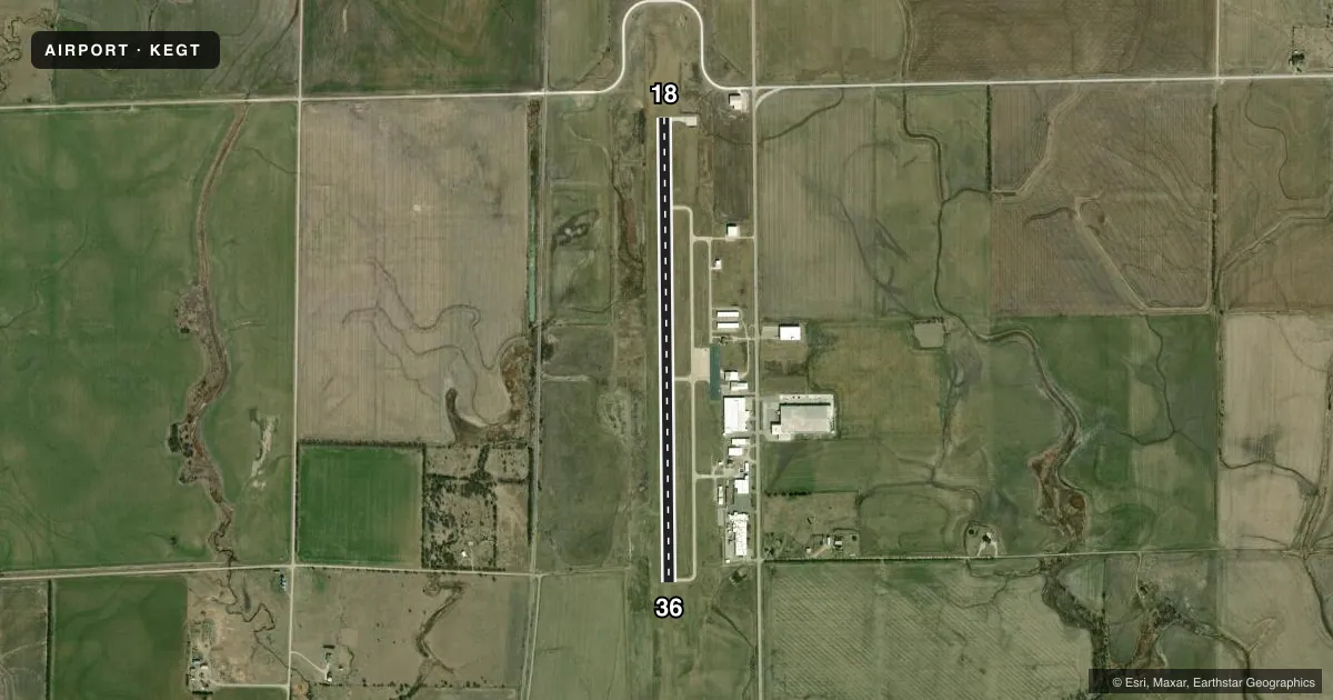
Runways & pattern
Full pagePattern entry · RWY 18
LEFT TRAFFICRunway end performance
| End | TORA | TODA | ASDA | LDA | VGSI | Approach lights | Obstruction |
|---|---|---|---|---|---|---|---|
| 18 | — | — | — | — | PAPI 4-box left(3°) | — | — |
| 36 | — | — | — | — | PAPI 4-box left(3°) | — | — |
Declared distances in feet. TORA = takeoff run available, TODA = takeoff distance, ASDA = accelerate-stop, LDA = landing distance.
Airport sketch
Runways drawn to scale from FAA survey coordinates, rendered over satellite imagery. Not for navigation.
Approaches & charts
Services on the field
Fuel grades, oxygen, maintenance, ramp storage and lighting — as declared to the FAA by the airport operator.
Fuel & services
- Fuel
- 100LLA
- Oxygen (bottled)
- Not available
- Oxygen (bulk)
- Not available
- Airframe repair
- Major
- Power plant repair
- Major
- Other services
- AGRI,CHTR,INSTR
Ramp & ground
- Transient storage
- Tie-down
- Landing fee
- No fee published
- Customs
- Not available
- Lighting schedule
- SEE RMK
- Beacon schedule
- SS-SR
- Beacon
- White / Green (civil land)(WG)
- Wind indicator
- Lighted
- Segmented circle
- No
Fuel & FBOs
Cheapest 100LL and Jet A on the field and nearby. Always confirm with the FBO before taxi.
Airport notes
Surface conditions, obstructions, local procedures, lighting outages and other notes published with each FAA cycle.
General notes
- SPECIAL REQS & AFT HRS CALL 620-440-2213.
- KEY CODE FOR PILOT LOUNGE 1228
- FOR CD CTC WICHITA APCH AT 316-350-1520.
Lighting notes
- ACTVT REIL RWY 18 & 36; PAPI RWY 18 & 36; HIRL RWY 18/36 - CTAF.
Fuel notes
- 100LL100 LL 24 HR SELF SVC.
- AAFT HRS CALL 620-440-2213.
VFR map & nearby airports
VFR sectional. Tap any ICAO chip to open that airport.
Key facts · KEGT
Answer card- ICAO
- KEGT
- Name
- WELLINGTON MUNI
- Location
- WELLINGTON, KANSAS
- Elevation
- 1,277 ft MSL
- Traffic pattern altitude
- 2,277 ft MSL (1,000 AGL)
- Control tower
- Non-towered (use CTAF)
- Total runways
- 1
- Longest runway
- 18/36 · 5,201 ft
- Published ILS approaches
- 0
- Published frequencies
- 3
- Magnetic variation
- 3°
- Current flight rules
- VFR
- Current wind
- 200° at 8 kt
- Favored runway now
- RWY 18
Wellington Muni sits in Wellington, Kansas. Field elevation is 1,277 ft MSL. The airport has one runway. Runway 18/36 is 5,201 ft long with a concrete surface. There is no control tower. CTAF and UNICOM are both 122.8. Wichita Approach handles APCH and P DEP on 134.85.
No ILS approaches are published here. Pattern altitude is not published, so use the standard 1,000 ft AGL for light piston traffic unless local procedures say otherwise. The runway lighting setup is useful after dark. Runway end identifier lights are installed on 18 and 36. PAPI is available on both ends. High intensity runway lights are controlled on CTAF.
Wellington Municipal Airport is the on-field FBO. It carries 100LL and Jet A. 100LL is available 24 hours by self-service. For after-hours fuel service or special requests, call the airport at 620-440-2213. The pilot lounge key code is 1228.
For a first-time arrival, the main things to plan around are the non-towered pattern. Wichita Approach frequency is also part of the arrival picture. The lighting setup matters if you are arriving at night. Check the current FAA Chart Supplement for any updated local procedures before you go.