METAR & TAF 71K
71K does not publish a METAR.
Showing the nearest reporting station: KICT (WICHITA DWIGHT D EISENHOWER NTL) · 2.3 NM away. Conditions at 71K may differ.
METAR · KICT
Observed 16:53Z
KICT 271653Z 19012KT 10SM FEW200 36/19 A2986 RMK AO2 SLP091 T03610189
- Wind
- 190° @ 12 kt
- Visibility
- 10 SM
- Temp / Dew
- 36°C / 19°C
- Altimeter
- 29.86 inHg
- Clouds
- FEW
- Density alt
- 4,194 ft
- Ceiling
- Unlimited
- Rules
- VFR
Airport info & contacts
Manager on record, flight service, ARTCC, attendance schedule and pattern altitude — published by the FAA and refreshed every 28 days.
Location
- From city
- 3 NM SW
- VFR sectional
- WICHITA
- ARTCC
- ZKC · KANSAS CITY
- NOTAM facility
- ICT (NOTAM-D)
Airport manager
- Name
- EARL V. LONG
- Phone
- 316-943-5510
- Address
- 2558 S KESSLER, WICHITA KS 67217
Flight service · Hours
- FSS ICT
- WICHITA1-800-WX-BRIEF
- Attendance
- DALGT
Frequencies
Tap any row to copy the frequency to your clipboard.
Runways & pattern
Full pagePattern entry · RWY 17
LEFT TRAFFICRunway end performance
| End | TORA | TODA | ASDA | LDA | VGSI | Approach lights | Obstruction |
|---|---|---|---|---|---|---|---|
| 17 | — | — | — | — | — | — | 20', pole, 201' from thr, 0' R of cntrln, slope 0 |
| 35 | — | — | — | — | — | — | 7', fence, 201' from thr, 69' R of cntrln, slope 0 |
Declared distances in feet. TORA = takeoff run available, TODA = takeoff distance, ASDA = accelerate-stop, LDA = landing distance.
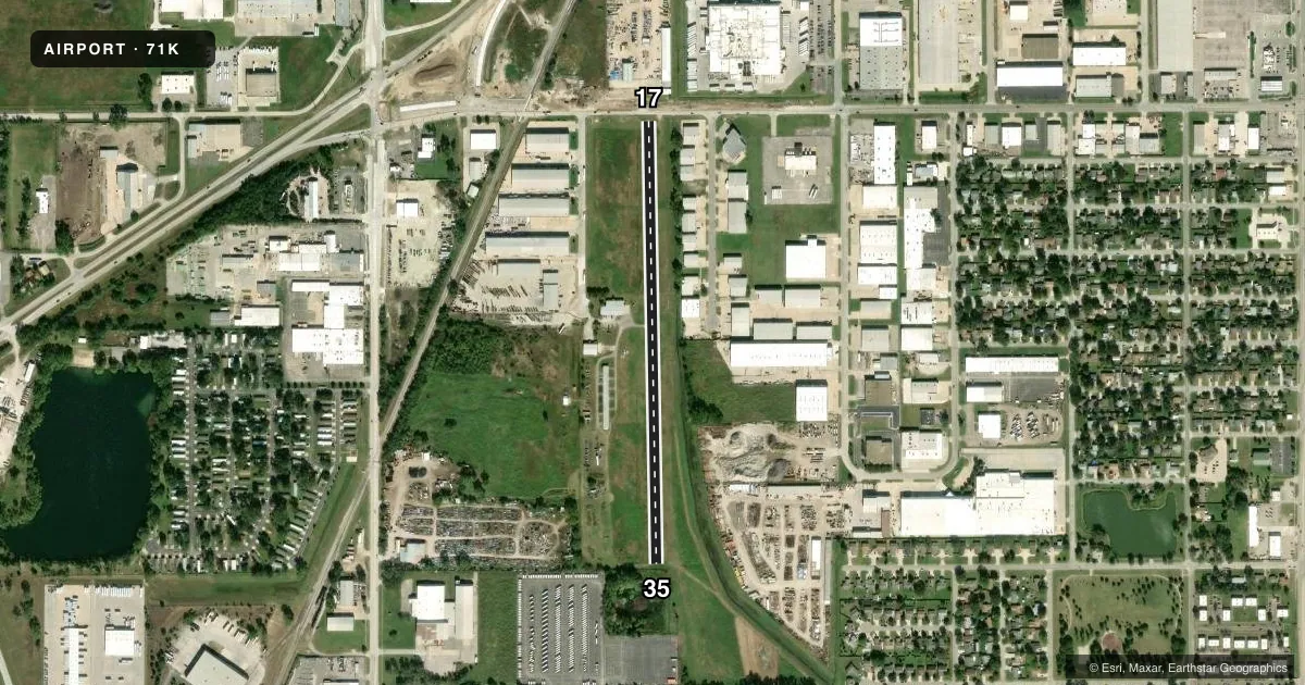
Airport sketch
Runways drawn to scale from FAA survey coordinates, rendered over satellite imagery. Not for navigation.
Approaches & charts
Services on the field
Fuel grades, oxygen, maintenance, ramp storage and lighting — as declared to the FAA by the airport operator.
Fuel & services
- Fuel
- 100LL
- Oxygen (bottled)
- Not available
- Oxygen (bulk)
- Not available
- Airframe repair
- Major
- Power plant repair
- Major
- Other services
- INSTR,RNTL
Ramp & ground
- Transient storage
- Tie-down
- Hangar
- Landing fee
- No fee published
- Customs
- Not available
- Wind indicator
- Yes
- Segmented circle
- No
Fuel & FBOs
Cheapest 100LL and Jet A on the field and nearby. Always confirm with the FBO before taxi.
Airport notes
Surface conditions, obstructions, local procedures, lighting outages and other notes published with each FAA cycle.
General notes
- DEPS CTC WICHITA ATCT ON THE GROUND ON FREQ 125.7 FOR DEP INSTRUCTIONS. IF UNABLE - CONTACT ATCT ON FREQ 118.2 UPON DEP & REMAIN EAST OF THE FIELD UNTIL COMMUNICATIONS ARE ESTABLISHED.
- FOR CD CTC WICHITA APCH AT 316-350-1520.
Approach & departure obstructions
- 1715 FT RD, 28 FT DSTC, 125 FT L/R/ 25 FT POLE LINE, 83 FT DSTC, 125 FT L/R.
- 357 FT FENCE 50 FT FROM THR; BOTH SIDES OF CNTRLN.
- 17ALSO 46 FT UNMKD POLE, 400 FT DSTC, 0 B 4:1.
Other notes
- PRVDD RT TFC PAT IS ESTABD FOR RWY & APCHS OF 20:1 & TRSNL SFC OF 7:1 ARE MAINT.
- 17/35RWY 17/35 GRASS ENCROACHING ON RWY SIDES NUMEROUS SURFACE CRACKS.
VFR map & nearby airports
VFR sectional. Tap any ICAO chip to open that airport.
Key facts · 71K
Answer card- ICAO
- 71K
- Name
- WESTPORT
- Location
- WICHITA, KANSAS
- Elevation
- 1,290 ft MSL
- Traffic pattern altitude
- 2,290 ft MSL (1,000 AGL)
- Control tower
- Non-towered (use CTAF)
- Total runways
- 1
- Longest runway
- 17/35 · 2,520 ft
- Published ILS approaches
- 0
- Published frequencies
- 1
- Magnetic variation
- 7°
- Current flight rules
- VFR
- Current wind
- 190° at 12 kt
- Favored runway now
- RWY 17
Westport Airport (71K) sits in Wichita, Kansas. Field elevation is 1,290 ft MSL. The airport has one asphalt runway, 17/35, at 2,520 ft. There is no control tower. CTAF is 122.9. No ILS approaches are published here. The pattern altitude is not published. Use the standard 1,000 ft AGL pattern only if that matches current local practice and the current Chart Supplement does not say otherwise.
Westport Ag Sales and Service is on the field. It carries 100LL. Call (316) 943-5510 for current service details before you go. Published remarks also call out runway condition issues on 17/35. Expect grass encroachment on the sides and numerous surface cracks. There are also obstruction notes near runway 17 and a fence near the threshold of runway 35. That makes a close look at the current Chart Supplement worth doing before departure.
This is a non-towered field in the Wichita area, so plan for local traffic and coordinate carefully. Published remarks say departures should contact Wichita ATC on the ground for departure instructions. If that does not work, contact the tower after takeoff and remain east of the field until communications are established. The remarks also mention clearance delivery through Wichita Approach. Check the current Chart Supplement for any additional local procedures before flying in.