METAR & TAF 55K
55K does not publish a METAR.
Showing the nearest reporting station: KWLD (STROTHER FLD) · 6.6 NM away. Conditions at 55K may differ.
METAR · KWLD
Observed 12:54Z
KWLD 271254Z AUTO 17009KT 10SM CLR 27/19 A2990 RMK AO2 SLP109 T02670194
- Wind
- 170° @ 9 kt
- Visibility
- 10 SM
- Temp / Dew
- 27°C / 19°C
- Altimeter
- 29.90 inHg
- Clouds
- CLR
- Density alt
- 2,945 ft
- Ceiling
- Unlimited
- Rules
- VFR
Airport info & contacts
Manager on record, flight service, ARTCC, attendance schedule and pattern altitude — published by the FAA and refreshed every 28 days.
Location
- From city
- 4 NM E
- VFR sectional
- WICHITA
- ARTCC
- ZKC · KANSAS CITY
- NOTAM facility
- ICT (NOTAM-D)
Airport manager
- Name
- PATRICK KOPFER
- Phone
- 620-455-2223
- Address
- 115 SO. SUMNER, P.O. BOX 337, OXFORD KS 67119
Flight service · Hours
- FSS ICT
- WICHITA1-800-WX-BRIEF
- Attendance
- Unattended
Frequencies
Tap any row to copy the frequency to your clipboard.
Runways & pattern
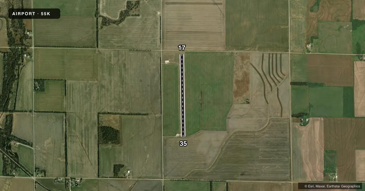
Full pagePattern entry · RWY 17
LEFT TRAFFICAirport sketch
Runways drawn to scale from FAA survey coordinates, rendered over satellite imagery. Not for navigation.
Approaches & charts
Services on the field
Fuel grades, oxygen, maintenance, ramp storage and lighting — as declared to the FAA by the airport operator.
Fuel & services
- Fuel
- Not available
- Oxygen (bottled)
- Not available
- Oxygen (bulk)
- Not available
- Airframe repair
- Not available
- Other services
- AGRI
Ramp & ground
- Transient storage
- Tie-down
- Landing fee
- No fee published
- Customs
- Not available
- Wind indicator
- Yes
- Segmented circle
- No
Fuel & FBOs
Cheapest 100LL and Jet A on the field and nearby. Always confirm with the FBO before taxi.
Airport notes
Surface conditions, obstructions, local procedures, lighting outages and other notes published with each FAA cycle.
General notes
- FOR CD CTC WICHITA APCH AT 316-350-1520.
Approach & departure obstructions
- 17+15 FT ROAD 140 FT FROM EOR.
Other notes
- EXISTED PRIOR TO 1959.
VFR map & nearby airports
VFR sectional. Tap any ICAO chip to open that airport.
Key facts · 55K
Answer card- ICAO
- 55K
- Name
- OXFORD MUNI
- Location
- OXFORD, KANSAS
- Elevation
- 1,194 ft MSL
- Traffic pattern altitude
- 2,194 ft MSL (1,000 AGL)
- Control tower
- Non-towered (use CTAF)
- Total runways
- 1
- Longest runway
- 17/35 · 3,380 ft
- Published ILS approaches
- 0
- Published frequencies
- 1
- Magnetic variation
- 7°
- Current flight rules
- VFR
- Current wind
- 170° at 9 kt
- Favored runway now
- RWY 17
Oxford Muni sits in Oxford, Kansas. The field elevation is 1,194 ft MSL. It has one runway, 17/35, which is 3,380 ft of asphalt. The airport is non-towered. CTAF is 122.9. No ILS approaches are published here.
The pattern altitude is not published in the facts. Use the standard 1,000 ft AGL for light piston planning unless the current FAA Chart Supplement says otherwise. That puts the working pattern reference at about 2,194 ft MSL based on the field elevation. Verify the current published pattern before you go.
There are no on-field FBOs listed in the facts. Contact the airport operator directly before arrival, or call the field on CTAF for current fuel and service availability. Published remarks note a 15 ft road about 140 ft from the departure end of runway 17. That matters on takeoff and landing planning. Clearance delivery is handled through Wichita Approach at 316-350-1520. This is a small, non-towered field with one short asphalt runway, so plan your arrival and departure carefully. Check the current Chart Supplement for any changes before flight.