METAR & TAF KEQA
Current METAR
Observed 18:15Z
KEQA 271815Z AUTO 21009KT 10SM CLR 37/21 A2986 RMK AO2
- Wind
- 210° @ 9 kt
- Visibility
- 10 SM
- Temp / Dew
- 37°C / 21°C
- Altimeter
- 29.86 inHg
- Clouds
- CLR
- Density alt
- 4,425 ft
- Ceiling
- Unlimited
- Rules
- VFR
Airport info & contacts
Manager on record, flight service, ARTCC, attendance schedule and pattern altitude — published by the FAA and refreshed every 28 days.
Location
- From city
- 3 NM SE
- VFR sectional
- KANSAS CITY
- ARTCC
- ZKC · KANSAS CITY
- NOTAM facility
- ICT (NOTAM-D)
Airport manager
- Name
- LARRY ARNOLD
- Phone
- 316-321-1327
- Address
- 220 E 1ST AVE, EL DORADO KS 67042
Flight service · Hours
- FSS ICT
- WICHITA1-800-WX-BRIEF
- Attendance
- MON-FRI · 0700-1500
Frequencies
Tap any row to copy the frequency to your clipboard.
Runways & pattern
Full pagePattern entry · RWY 22
LEFT TRAFFIC| Runway | Heading (°M) | Length | Surface | Traffic |
|---|---|---|---|---|
| 04/22Favored | 38° / 218° | 4,204 ft | ASPH | Standard L |
| 15/33 | 154° / 334° | 4,200 ft | CONC | Standard L |
Runway end performance
| End | TORA | TODA | ASDA | LDA | VGSI | Approach lights | Obstruction |
|---|---|---|---|---|---|---|---|
| 04 | — | — | — | — | PAPI 2-box left(3°) | — | 10', trees, 290' from thr, 175' R of cntrln, slope 9 |
| 22 | — | — | — | — | PAPI 2-box left(3°) | — | — |
| 15 | — | — | — | — | PAPI 2-box left(3°) | — | 40', trees, 1160' from thr, 0' R of cntrln, slope 24 |
| 33 | — | — | — | — | PAPI 2-box left(3°) | — | — |
Declared distances in feet. TORA = takeoff run available, TODA = takeoff distance, ASDA = accelerate-stop, LDA = landing distance.
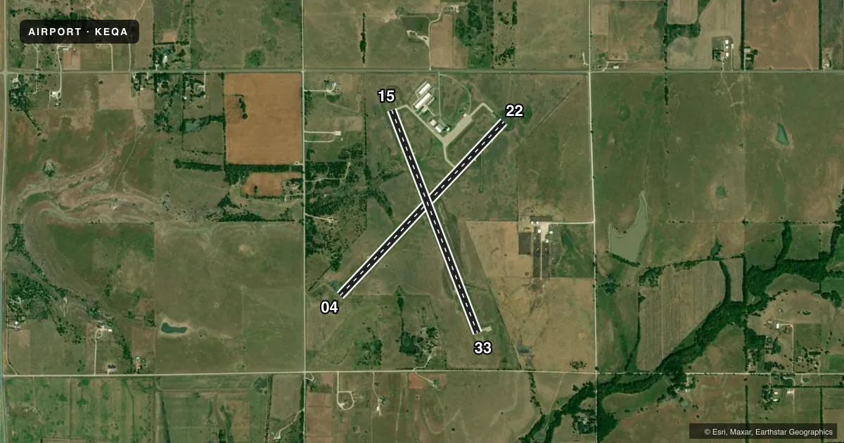
Airport sketch
Runways drawn to scale from FAA survey coordinates, rendered over satellite imagery. Not for navigation.
Approaches & charts
Services on the field
Fuel grades, oxygen, maintenance, ramp storage and lighting — as declared to the FAA by the airport operator.
Fuel & services
- Fuel
- 100LLAMOGAS
- Oxygen (bottled)
- Not available
- Oxygen (bulk)
- Not available
- Airframe repair
- Major
- Power plant repair
- Major
- Other services
- INSTR,RNTL
Ramp & ground
- Transient storage
- Tie-down
- Hangar
- Landing fee
- No fee published
- Customs
- Not available
- Lighting schedule
- SEE RMK
- Beacon schedule
- SS-SR
- Beacon
- White / Green (civil land)(WG)
- Wind indicator
- Lighted
- Segmented circle
- Yes
Fuel & FBOs
Cheapest 100LL and Jet A on the field and nearby. Always confirm with the FBO before taxi.
Airport notes
Surface conditions, obstructions, local procedures, lighting outages and other notes published with each FAA cycle.
General notes
- AVOID FLT OVR PRISON N OF ARPT.
- FOR CD CTC WICHITA APCH AT 316-350-1520.
- AFT HRS PHONE NMBR POSTED AT ARPT.
- COURTESY CAR.
- TERMINAL ACCESS AFT HRS CTAF.
- PHYS ADR 1485 S.E. 30TH.
Lighting notes
- ACTVT PAPI RWY 04 & 22, 15 & 33; HIRL 4/22 AND 15/33 - CTAF.
Fuel notes
- 100LL100 LL, JET A, MOGAS 24 HR SELF-SERVE.
Approach & departure obstructions
- 0415 FT TREES, 60-200 FT DSTC, 215 FT L.
Other notes
- PRVDD THE APCH TO EACH RWY IS MAINTD FOR A MIN 20:1 GLIDE SLOPE AND THE TRSNL SFC BE MAINTD FOR A 7:1 SLOPE.
VFR map & nearby airports
VFR sectional. Tap any ICAO chip to open that airport.
Key facts · KEQA
Answer card- ICAO
- KEQA
- Name
- EL DORADO/CAPT JACK THOMAS MEML
- Location
- EL DORADO, KANSAS
- Elevation
- 1,379.3 ft MSL
- Traffic pattern altitude
- 2,379.3 ft MSL (1,000 AGL)
- Control tower
- Non-towered (use CTAF)
- Total runways
- 2
- Longest runway
- 04/22 · 4,204 ft
- Published ILS approaches
- 0
- Published frequencies
- 4
- Magnetic variation
- 5°
- Current flight rules
- VFR
- Current wind
- 210° at 9 kt
- Favored runway now
- RWY 22
KEQA is in El Dorado, Kansas. Field elevation is 1,379.3 ft MSL. It has two runways. The longest is runway 04/22 at 4,204 ft. This is a non-towered field, so plan to use CTAF 122.8 for local traffic calls and for PAPI activation. No ILS approaches are published here. Pattern altitude is not published. For light piston operations, use 1,000 ft AGL unless the current Chart Supplement or local procedures say otherwise.
The on-field FBO is El Dorado Airport. It carries 100LL, Jet A and mogas. Self-serve fuel is available 24 hours. The airport remarks also note high intensity runway lighting on both runways. The PAPI can be activated on 04, 22, 15 and 33 using CTAF. There is a tree obstruction near the approach to runway 04. It sits left of the runway. Give that end a careful look on approach. The airport also advises pilots to avoid overflight of the prison north of the field.
Wichita Approach handles clearance delivery and approach control. That matters if you are filing IFR or need radar services. The field sits in Kansas terrain with no tower. Expect normal non-towered traffic discipline. Check the current Chart Supplement for any changes before you go.