METAR & TAF KIDP
Current METAR
Observed 19:10Z
KIDP 271910Z AUTO 19014KT 10SM CLR 38/21 A2984 RMK AO2
- Wind
- 190° @ 14 kt
- Visibility
- 10 SM
- Temp / Dew
- 38°C / 21°C
- Altimeter
- 29.84 inHg
- Clouds
- CLR
- Density alt
- 3,882 ft
- Ceiling
- Unlimited
- Rules
- VFR
Airport info & contacts
Manager on record, flight service, ARTCC, attendance schedule and pattern altitude — published by the FAA and refreshed every 28 days.
Location
- From city
- 5 NM SW
- VFR sectional
- KANSAS CITY
- ARTCC
- ZKC · KANSAS CITY
- NOTAM facility
- ICT (NOTAM-D)
Airport manager
- Name
- AARON SHRADER
- Phone
- 620-332-2531
- Address
- 498 FREEDOM DRIVE, INDEPENDENCE KS 67301
Flight service · Hours
- FSS ICT
- WICHITA1-800-WX-BRIEF
- Attendance
- MON-FRI · 0700-1800
Frequencies
Tap any row to copy the frequency to your clipboard.
Runways & pattern
Full pagePattern entry · RWY 17
LEFT TRAFFIC| Runway | Heading (°M) | Length | Surface | Traffic |
|---|---|---|---|---|
| 17/35Favored | 178° / 358° | 5,501 ft | ASPH | Standard L |
| 04/22 | 43° / 223° | 3,402 ft | ASPH | Standard L |
Runway end performance
| End | TORA | TODA | ASDA | LDA | VGSI | Approach lights | Obstruction |
|---|---|---|---|---|---|---|---|
| 17 | — | — | — | — | — | — | 50', trees, 2351' from thr, 0' R of cntrln, slope 43 |
| 35 | — | — | — | — | PAPI 4-box left(3°) | MALSR | — |
| 04 | — | — | — | — | PAPI 4-box left | — | — |
| 22 | — | — | — | — | PAPI 4-box left | — | — |
Declared distances in feet. TORA = takeoff run available, TODA = takeoff distance, ASDA = accelerate-stop, LDA = landing distance.
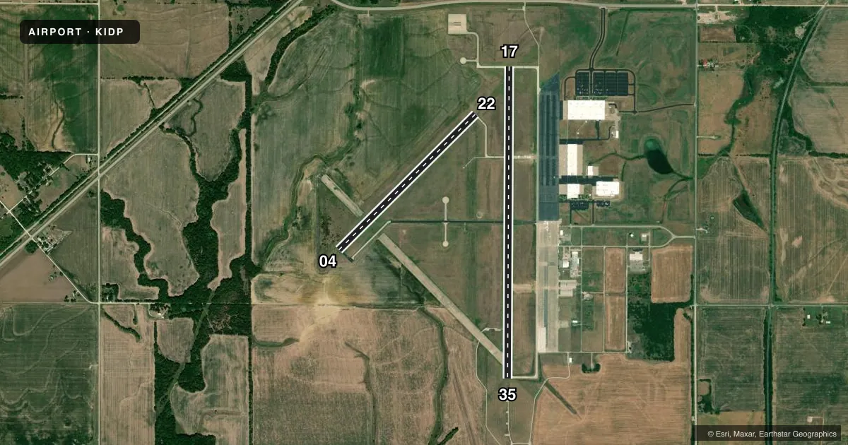
Airport sketch
Runways drawn to scale from FAA survey coordinates, rendered over satellite imagery. Not for navigation.
Approaches & charts
ILS · 1
Services on the field
Fuel grades, oxygen, maintenance, ramp storage and lighting — as declared to the FAA by the airport operator.
Fuel & services
- Fuel
- 100LLA
- Oxygen (bottled)
- Not available
- Oxygen (bulk)
- Not available
- Airframe repair
- Minor
- Power plant repair
- Major
- Other services
- AGRI,INSTR,RNTL
Ramp & ground
- Transient storage
- Tie-down
- Landing fee
- No fee published
- Customs
- Not available
- Lighting schedule
- SEE RMK
- Beacon schedule
- SS-SR
- Beacon
- White / Green (civil land)(WG)
- Wind indicator
- Yes
- Segmented circle
- Yes
Fuel & FBOs
Cheapest 100LL and Jet A on the field and nearby. Always confirm with the FBO before taxi.
Airport notes
Surface conditions, obstructions, local procedures, lighting outages and other notes published with each FAA cycle.
General notes
- MANUFACTURED ACFT TESTING ON & INVOF ARPT
- CROP DUSTING ACFT & AGRICULTURAL EQUIP ON & INVOF ARPT.
- MIGRATORY BIRDS & WATERFOWL ON & INVOF ARPT.
- WILDLIFE ON & INVOF RWYS.
- RWY 04/22 NO LINE ON SIGHT BETWEEN RWY ENDS.
- EXTSV FLT TESTING & FLT TRNG.
- FARM MACHINERY ON ARPT.
- CROP DUSTING ACTIVITY INVOF ARPT.
- RWY 35 DSGNDAS CALM WIND RWY.
- FOR CD CTC KANSAS CITY ARTCC AT 913-254-8508.
Lighting notes
- ACTVT MALSR RWY 35; PAPI RWY 04 & 22; MIRL RWY 04 & 22: HIRL RWY 17 & 35 - CTAF.
Fuel notes
- 100LL100LL ONLY SELF SVC AVBL 24 HRS.
Approach & departure obstructions
- 0415 FT TREES 72 FT DST, 186 FT L.
Other notes
- PRVDD A CLEAR APCH TO EACH RY MAINTAINED FOR A MINIMUM 20:1 GLIDE SLOPE & A CLEAR TRANSITIONAL SFC IS MAINTAINED FOR A 7:1 SLOPE.
VFR map & nearby airports
VFR sectional. Tap any ICAO chip to open that airport.
Key facts · KIDP
Answer card- ICAO
- KIDP
- Name
- INDEPENDENCE MUNI
- Location
- INDEPENDENCE, KANSAS
- Elevation
- 824.7 ft MSL
- Traffic pattern altitude
- 1,824.7 ft MSL (1,000 AGL)
- Control tower
- Non-towered (use CTAF)
- Total runways
- 2
- Longest runway
- 17/35 · 5,501 ft
- Published ILS approaches
- 1
- Published frequencies
- 2
- Magnetic variation
- 2°
- Current flight rules
- VFR
- Current wind
- 190° at 14 kt
- Favored runway now
- RWY 17
INDEPENDENCE MUNI sits in Independence, Kansas. The field elevation is 824.7 ft MSL. It has two asphalt runways. The longest is runway 17/35 at 5,501 ft. Runway 04/22 is 3,402 ft. There is no control tower. CTAF and UNICOM are both 123.05.
One ILS approach is published for runway 35. The pattern altitude is not published in the facts. Use the standard 1,000 ft AGL for light piston operations unless the current FAA Chart Supplement says otherwise. The airport is active with crop dusting traffic, farm machinery, wildlife and flight training. Runway 35 is the calm wind runway. Runway 04/22 has no line of sight between the ends. There are 15 ft trees 72 ft distant, 186 ft left of runway 04, so keep that in mind on short final.
Independence Municipal Airport is the on-field FBO. It carries 100LL and Jet A Prist. 100LL self-serve is available 24 hours. Lighting is mixed by runway. Runway 35 has MALSR. Runways 17 and 35 have high intensity runway lighting. Runways 04 and 22 have PAPI and medium intensity runway lighting. For clearance delivery, contact Kansas City ARTCC. A first-time pilot should expect a busy non-towered field with ag traffic. Use CTAF early and often.