METAR & TAF KBVO
Current METAR
Observed 17:53Z
KBVO 271753Z AUTO 21008KT 10SM CLR 38/20 A2987 RMK AO2 SLP100 T03780200 10378 20228 58012
- Wind
- 210° @ 8 kt
- Visibility
- 10 SM
- Temp / Dew
- 38°C / 20°C
- Altimeter
- 29.87 inHg
- Clouds
- CLR
- Density alt
- 3,711 ft
- Ceiling
- Unlimited
- Rules
- VFR
Airport info & contacts
Manager on record, flight service, ARTCC, attendance schedule and pattern altitude — published by the FAA and refreshed every 28 days.
Location
- From city
- 2 NM NW
- VFR sectional
- KANSAS CITY
- ARTCC
- ZKC · KANSAS CITY
- NOTAM facility
- BVO (NOTAM-D)
Airport manager
- Name
- MIKE RICHARDSON
- Phone
- (918) 661-3500
- Address
- 401 NW WILEY POST RD., BARTLESVILLE OK 74003
Flight service · Hours
- FSS MLC
- MC ALESTER1-800-WX-BRIEF
- Attendance
- MON-THU · 0700-1900
- FRI-SUN · 0700-1800
Frequencies
Tap any row to copy the frequency to your clipboard.
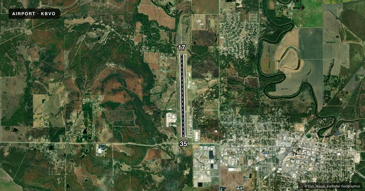
Runways & pattern
Full pagePattern entry · RWY 17
RIGHT TRAFFICRunway end performance
| End | TORA | TODA | ASDA | LDA | VGSI | Approach lights | Obstruction |
|---|---|---|---|---|---|---|---|
| 17 | 6,201' | 6,201' | 6,201' | 6,201' | PAPI 4-box left(3°) | MALSR | 31', trees, 572' from thr, 344' R of cntrln, slope 12 |
| 35 | 6,850' | 6,850' | 6,850' | 6,201' | PAPI 4-box left(3°) | — | — |
Declared distances in feet. TORA = takeoff run available, TODA = takeoff distance, ASDA = accelerate-stop, LDA = landing distance.
Airport sketch
Runways drawn to scale from FAA survey coordinates, rendered over satellite imagery. Not for navigation.
Approaches & charts
ILS · 1
Services on the field
Fuel grades, oxygen, maintenance, ramp storage and lighting — as declared to the FAA by the airport operator.
Fuel & services
- Fuel
- 100LLA+
- Oxygen (bottled)
- Low pressure
- Oxygen (bulk)
- Not available
- Airframe repair
- Major
- Power plant repair
- Major
- Other services
- AGRI,INSTR
Ramp & ground
- Transient storage
- Tie-down
- Hangar
- Landing fee
- No fee published
- Customs
- Not available
- Lighting schedule
- SEE RMK
- Beacon schedule
- SS-SR
- Beacon
- White / Green (civil land)(WG)
- Wind indicator
- Lighted
- Segmented circle
- Yes
Fuel & FBOs
Cheapest 100LL and Jet A on the field and nearby. Always confirm with the FBO before taxi.
Airport notes
Surface conditions, obstructions, local procedures, lighting outages and other notes published with each FAA cycle.
General notes
- FOR CD IF UNA TO CTC ON FSS FREQ, CTC KANSAS CITY ARTCC AT 913-254-8508.
Lighting notes
- ACTVT MALSR RWY 17; REIL RWY 35; PAPI RWY 17 & 35 - CTAF. MIRL RWY 17/35 OPER SS TO SR & PRESET LOW INTST, INCR INTST - CTAF.
Other notes
- ADZY FREQ 122.825 MNT M-F DURG BUS HRS.
- MANAGERFOR EMERG ONLY 918-350-0076.
VFR map & nearby airports
VFR sectional. Tap any ICAO chip to open that airport.
Key facts · KBVO
Answer card- ICAO
- KBVO
- Name
- BARTLESVILLE MUNI
- Location
- BARTLESVILLE, OKLAHOMA
- Elevation
- 716.9 ft MSL
- Traffic pattern altitude
- 1,716.9 ft MSL (1,000 AGL)
- Control tower
- Non-towered (use CTAF)
- Total runways
- 1
- Longest runway
- 17/35 · 6,850 ft
- Published ILS approaches
- 1
- Published frequencies
- 1
- Magnetic variation
- 3°
- Current flight rules
- VFR
- Current wind
- 210° at 8 kt
- Favored runway now
- RWY 17
Bartlesville Muni is in Bartlesville, Oklahoma. Field elevation is 716.9 ft MSL. The airport has one runway, 17/35 and it is 6,850 ft long. There is no control tower. CTAF is 122.825.
Runway 17 has the ILS approach. The published remarks also note medium intensity approach lighting with runway alignment indicator lights on 17. Runway 35 has runway end identifier lights. PAPI is available on both ends. The runway lights operate from sunset to sunrise and are preset to low intensity. You can increase intensity on CTAF.
Pattern altitude is not published. Use standard 1,000 ft AGL for light piston traffic unless the current Chart Supplement says otherwise. Bartlesville Aviation is on the field. It carries 100LL and Jet A. The airport is a good fit for pilots who want a long paved runway with instrument capability. Check the current Chart Supplement for any local procedures before arrival. The remarks also list ADZY monitoring on 122.825 Monday through Friday during business hours. For clearance delivery issues, the published remarks give a Kansas City Center phone number.