METAR & TAF KCFV
Current METAR
Observed 18:52Z
KCFV 271852Z AUTO 20013KT 10SM CLR 38/21 A2984 RMK AO2 SLP095 T03780206
- Wind
- 200° @ 13 kt
- Visibility
- 10 SM
- Temp / Dew
- 38°C / 21°C
- Altimeter
- 29.84 inHg
- Clouds
- CLR
- Density alt
- 3,795 ft
- Ceiling
- Unlimited
- Rules
- VFR
Airport info & contacts
Manager on record, flight service, ARTCC, attendance schedule and pattern altitude — published by the FAA and refreshed every 28 days.
Location
- From city
- 4 NM NE
- VFR sectional
- KANSAS CITY
- ARTCC
- ZKC · KANSAS CITY
- NOTAM facility
- CFV (NOTAM-D)
Airport manager
- Name
- JARROD POWERS
- Phone
- 620-252-8027
- Address
- 102 W 7TH ST, BOX 1629, COFFEYVILLE KS 67337
Flight service · Hours
- FSS ICT
- WICHITA1-800-WX-BRIEF
- Attendance
- MON-FRI · 0800-1700
Frequencies
Tap any row to copy the frequency to your clipboard.
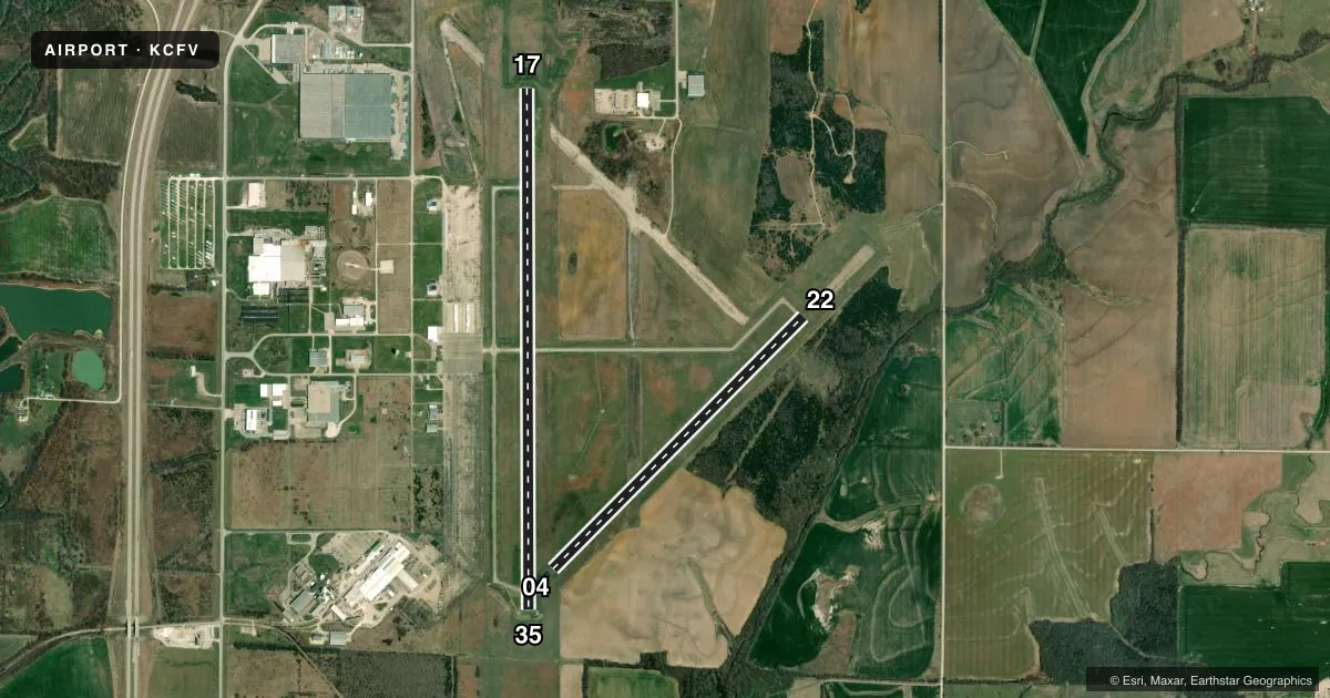
Runways & pattern
Full pagePattern entry · RWY 17
LEFT TRAFFIC| Runway | Heading (°M) | Length | Surface | Traffic |
|---|---|---|---|---|
| 17/35Favored | 175° / 355° | 5,868 ft | ASPH | Standard L |
| 04/22 | 40° / 220° | 4,005 ft | ASPH | Standard L |
Runway end performance
| End | TORA | TODA | ASDA | LDA | VGSI | Approach lights | Obstruction |
|---|---|---|---|---|---|---|---|
| 17 | — | — | — | — | PAPI 4-box left(3°) | — | 33', tree, 1405' from thr, 270' R of cntrln, slope 36 |
| 35 | — | — | — | — | PAPI 4-box left(3°) | — | tree, slope 50 |
| 04 | — | — | — | — | — | — | 39', tree, 1580' from thr, 65' R of cntrln, slope 35 |
| 22 | — | — | — | — | — | — | 22', trees, 1096' from thr, 60' R of cntrln, slope 40 |
Declared distances in feet. TORA = takeoff run available, TODA = takeoff distance, ASDA = accelerate-stop, LDA = landing distance.
Airport sketch
Runways drawn to scale from FAA survey coordinates, rendered over satellite imagery. Not for navigation.
Approaches & charts
Services on the field
Fuel grades, oxygen, maintenance, ramp storage and lighting — as declared to the FAA by the airport operator.
Fuel & services
- Fuel
- 100LLA+
- Oxygen (bottled)
- Not available
- Oxygen (bulk)
- Not available
- Airframe repair
- Not available
- Power plant repair
- Not available
Ramp & ground
- Transient storage
- Tie-down
- Hangar
- Landing fee
- No fee published
- Customs
- Not available
- Lighting schedule
- SEE RMK
- Beacon schedule
- SS-SR
- Beacon
- White / Green (civil land)(WG)
- Wind indicator
- Lighted
- Segmented circle
- No
Fuel & FBOs
Cheapest 100LL and Jet A on the field and nearby. Always confirm with the FBO before taxi.
Airport notes
Surface conditions, obstructions, local procedures, lighting outages and other notes published with each FAA cycle.
General notes
- DEER ON & INVOF ARPT.
- FOR CD CTC KANSAS CITY ARTCC AT 913-254-8508.
Lighting notes
- ACTVT REIL RWY 35; PAPI RWYS 17 & 35; MIRL 17/35 - CTAF.
VFR map & nearby airports
VFR sectional. Tap any ICAO chip to open that airport.
Key facts · KCFV
Answer card- ICAO
- KCFV
- Name
- COFFEYVILLE MUNI
- Location
- COFFEYVILLE, KANSAS
- Elevation
- 754.4 ft MSL
- Traffic pattern altitude
- 1,754.4 ft MSL (1,000 AGL)
- Control tower
- Non-towered (use CTAF)
- Total runways
- 2
- Longest runway
- 17/35 · 5,868 ft
- Published ILS approaches
- 0
- Published frequencies
- 2
- Magnetic variation
- 5°
- Current flight rules
- VFR
- Current wind
- 200° at 13 kt
- Favored runway now
- RWY 17
Coffeyville Muni sits in Coffeyville, Kansas. Field elevation is 754.4 ft MSL. The airport has two asphalt runways. The longest is runway 17/35 at 5,868 ft. There is no control tower. CTAF and UNICOM are both 123.0.
No ILS approaches are published here. Pattern altitude is not published, so use the standard 1,000 ft AGL for light piston operations unless the current FAA Chart Supplement says otherwise. The on-field FBO is Coffeyville Municipal Airport. It carries 100LL and Jet A. Call ahead at (620) 251-4310 for current service details.
A few runway details matter here. Runway 35 has runway end identifier lights. Runways 17 and 35 have PAPI. Medium intensity runway lights are installed on 17 and 35. They are controlled by CTAF. Deer are reported on and near the airport, so keep a sharp scan on taxi, takeoff and landing. For IFR clearance delivery, contact Kansas City ARTCC. If you need current noise or curfew details, check the current FAA Chart Supplement before you go.