METAR & TAF K67
K67 does not publish a METAR.
Showing the nearest reporting station: KMIO (MIAMI RGNL) · 16.7 NM away. Conditions at K67 may differ.
METAR · KMIO
Observed 20:35Z
KMIO 272035Z AUTO 21012KT 10SM CLR 37/22 A2983 RMK A01 TSNO
- Wind
- 210° @ 12 kt
- Visibility
- 10 SM
- Temp / Dew
- 37°C / 22°C
- Altimeter
- 29.83 inHg
- Clouds
- CLR
- Density alt
- 3,783 ft
- Ceiling
- Unlimited
- Rules
- VFR
Airport info & contacts
Manager on record, flight service, ARTCC, attendance schedule and pattern altitude — published by the FAA and refreshed every 28 days.
Location
- From city
- 3 NM E
- VFR sectional
- KANSAS CITY
- ARTCC
- ZKC · KANSAS CITY
- NOTAM facility
- ICT (NOTAM-D)
Airport manager
- Name
- CALVIN JURGENSEN
- Phone
- 620-429-0297
- Address
- 11570 SW WYANDOTTE RD, PO BOX 210, OSWEGO KS 67356-0210
Flight service · Hours
- FSS ICT
- WICHITA1-800-WX-BRIEF
- Attendance
- Unattended
Frequencies
Tap any row to copy the frequency to your clipboard.
Runways & pattern
Full pagePattern entry · RWY 17
LEFT TRAFFICRunway end performance
| End | TORA | TODA | ASDA | LDA | VGSI | Approach lights | Obstruction |
|---|---|---|---|---|---|---|---|
| 17 | — | — | — | — | — | — | 24', rr, 645' from thr, 175' R of cntrln, slope 18 |
Declared distances in feet. TORA = takeoff run available, TODA = takeoff distance, ASDA = accelerate-stop, LDA = landing distance.
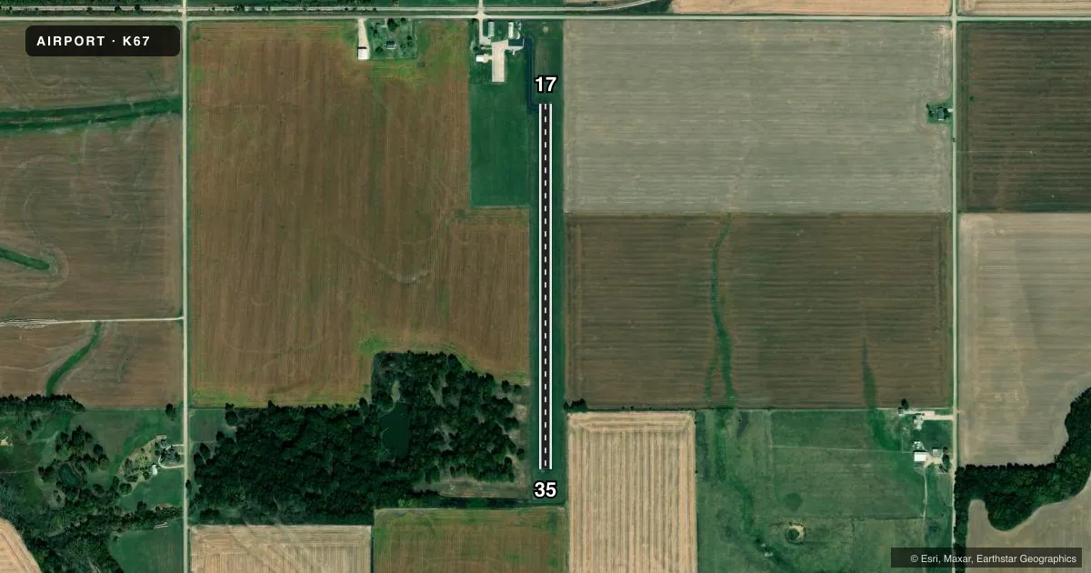
Airport sketch
Runways drawn to scale from FAA survey coordinates, rendered over satellite imagery. Not for navigation.
Approaches & charts
Services on the field
Fuel grades, oxygen, maintenance, ramp storage and lighting — as declared to the FAA by the airport operator.
Fuel & services
- Fuel
- 100LL
- Oxygen (bottled)
- Not available
- Oxygen (bulk)
- Not available
- Airframe repair
- Not available
- Power plant repair
- Not available
Ramp & ground
- Transient storage
- Tie-down
- Landing fee
- No fee published
- Customs
- Not available
- Lighting schedule
- SS-SR
- Beacon schedule
- SS-SR
- Beacon
- White / Green (civil land)(WG)
- Wind indicator
- Yes
- Segmented circle
- No
Fuel & FBOs
Cheapest 100LL and Jet A on the field and nearby. Always confirm with the FBO before taxi.
Airport notes
Surface conditions, obstructions, local procedures, lighting outages and other notes published with each FAA cycle.
General notes
- WILDLIFE ON & INVOF ARPT.
- FOR CD CTC KANSAS CITY ARTCC AT 913-254-8508.
Fuel notes
- 100LLFUEL 24HR SELF-SERVE.
Approach & departure obstructions
- 17RWY MKGS DISCOLORED.
Other notes
- MANAGERCITY SUPT/AMGR.
- 17/35RWY & TWY EXTENSIVE CRACKING.
VFR map & nearby airports
VFR sectional. Tap any ICAO chip to open that airport.
Key facts · K67
Answer card- ICAO
- K67
- Name
- OSWEGO MUNI
- Location
- OSWEGO, KANSAS
- Elevation
- 832 ft MSL
- Traffic pattern altitude
- 1,832 ft MSL (1,000 AGL)
- Control tower
- Non-towered (use CTAF)
- Total runways
- 1
- Longest runway
- 17/35 · 2,500 ft
- Published ILS approaches
- 0
- Published frequencies
- 1
- Magnetic variation
- 5°
- Current flight rules
- VFR
- Current wind
- 210° at 12 kt
- Favored runway now
- RWY 17
Oswego Muni sits in Oswego, Kansas. The field elevation is 832 ft MSL. It has one runway, 17/35, which is 2,500 ft long and asphalt. The airport is nontowered. CTAF is 122.9.
No ILS approaches are published here. The pattern altitude is not published in the facts, so plan to verify the current traffic pattern in the FAA Chart Supplement before you go. For clearance delivery, Kansas City ARTCC is listed at 913-254-8508. That matters if you are planning IFR or need current handling details.
Oswego Municipal Airport is the on-field FBO. It carries 100LL. Fuel is available as 24-hour self-serve. Call the airport at (620) 795-4433 if you need current ramp or fuel access details before arrival.
A few published remarks are worth a look before you fly in. Wildlife is reported on and near the airport. The runway markings are discolored. The runway and taxiway also have extensive cracking. For a first-time arrival, that means a careful look during rollout and taxi is smart. The airport manager is the city superintendent. Check current field conditions before you launch, especially if you are arriving at night or after weather has moved through the area.